 Grimshaw Entries in Parish Records of
Grimshaw Entries in Parish Records of
Churches in the Manchester Area
Roger Grimshaw performed an outstanding service for Grimshaw researchers by examining and recording "Grimshaw" entries in the parish registers of many of the churches in and around Manchester. Over 1300 records were found, including baptisms, marriages and burials for six churches as summarized below:
|
|
Baptisms |
Marriages |
Burials |
Total |
|
|
|
|
|
|
|
374 |
267 |
--- |
641 |
|
|
St
Michael and All Angels, Ashton |
129 |
49 |
--- |
178 |
Brookfield,
Gorton |
104 |
--- |
27 |
131 |
|
St
James, Gorton |
262 |
5 |
--- |
267 |
All
Saints, Newton Heath |
61 |
5 |
--- |
66 |
Other Churches near Manchester |
54 |
1 |
--- |
55 |
|
Total |
984 |
327 |
27 |
1338 |
Photos of the six churches are provided further down on this webpage along with brief descriptions of the communities in which they are located. Because of file size limitations, the Grimshaw records for each church are shown on separate webpages -- one for each church -- and may be viewed as follows:
Click here for Manchester Cathedral entries.
Click here for St Michael and All Angels Church, Ashton entries.
Click here for Brookfield Unitarian (Dissenting) Church, Gorton entries.
Click here for St James Church, Gorton entries.
Click here for All Saints Church, Newton Heath entries.
Click here for entries in other Manchester churches.
This webpage contains background information and photos of the six churches; the contents are as follows:
Roger Grimshaw's Email, December 2009
St Michael and All Angels Church, Ashton under Lyne
Brookfield Unitarian (Dissenting) Church, Gorton
All Saints Church, Newton Heath
Other Churches in the Manchester Area
| Webpage Credits |
Thanks go to Roger Grimshaw for collecting these records and making them available to other Grimshaw researchers on the "Grimshaw Origins" website.
| Roger Grimshaw's Email, December 2009 |
Roger initiated the recording of his work on this website with the email shown below.
Grimshaws in Manchester Parish Records
From: Roger Grimshaw (rogergrimshaw@yahoo.com)
Sent: Thu 12/24/09 2:31 PM
To: Thomas Grimshaw (thomas_grimshaw@hotmail.com)
Dear Thomas,
What a shock to the system to wake up to this on Christmas morning!!!
I have now tidied up some lists of parish records from selected churches in Manchester.
The selection is focused on East Manchester, particularly Gorton and Ashton under Lyne as this area is relevant to the Audenshaw Grimshaw line. However you will see that most of the christenings and marriages took place in Manchester Cathedral, including many from the Gorton/Openshaw area. For a discussion on this see:
- - - it is not a situation the church will be proud of!!
Some of the material has been extracted by scouring microfilms in Manchester Central Reference Library, while the rest have been derived from IGI microfilm. I must give credit to the excellent search tool developed by Hugh Wallis:
http://freepages.genealogy.rootsweb.ancestry.com/~hughwallis/IGIBatchNumbers.htm
which has been of enormous help. Some gaps have been filled by the searchable databases of www.lancashirebmd.org.uk and www.cheshirebmd.org.uk.
I also include details of Grimshaws trading in Manchester in 1788 and 1824, extracted from bound volumes in Manchester Central Ref.
Please find a total of seven files attached.
Note Jane Stanfield in Newton Heath 1824, and Robert and Lucretia at M/c Cath 1830, as well as her parents in 1781. Also Robert Grimshaw trading in Manchester in 1788.
Thomas, I hope this does not raise any copyright issues. I have referenced all my sources, and each line of entry required much further research and file manipulation. I propose that they should be made generally available to all the Grimshaw Forum, as they will be of general interest, but you must be the final arbiter.
More to follow on Samuel Grimshaw's birth in 1839/40 to Robert and Lucretia, and some corrections to the descendants' chart of Samuel and his offspring.
All the best for Christmas and the New Year from Roger and Maggie Grimshaw way over in little old England.
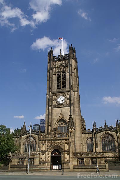
| Grimshaw Entries in Parish Records of Manchester Cathedral |
Grimshaw records at Manchester Cathedral include 374 baptisms and approximately 268 marriages. Click here for the Manchester Cathedral entries.
A photo of Manchester Cathedral appears below, followed by the Wikipedia description of the church. Click here to visit the cathedral website.
Source: http://www.freefoto.com/preview/807-08-9092?ffid=807-08-9092
The Wikipedia entry on Manchester cathedral is as follows:
Manchester Cathedral
From Wikipedia, the free encyclopedia
Manchester Cathedral is a Medieval church located on Victoria Street in central Manchester and is the seat of the Bishop of Manchester. The cathedral's official name is The Cathedral and Collegiate Church of St Mary, St Denys and St George in Manchester. It has also variously been known locally as St Mary's, Christ Church and, simply, t'owd church.[1]
Although extensively refaced, restored and extended in the Victorian period, and then again following severe bomb damage in the 20th century, the main body of the Cathedral largely derives from the wardenship of James Stanley (warden 1485 - 1506), and is in the Perpendicular Gothic style. Stanley was also primarily responsible for commissioning the spectacular late-medieval wooden furnishings, including the pulpitum, the choir stalls, and the nave roof supported by angels with gilded instruments. It is one of the Grade I listed buildings in Manchester. The Cathedral's current Dean is the Very Reverend Rogers Morgan Govender.[2] The previous Dean, the Very Reverend Kenneth Riley retired in 2005.
Services are currently held on Mondays to Fridays at 9:00am (Morning Prayer), 1:10pm (Holy Communion), and 5:30pm (Evensong); on Saturdays at 9:00am (Morning Prayer), 9:15am (Holy Communion), and 3:30pm (Evensong); and on Sundays at 8:45am (Morning Prayer), 9:00am (Holy Communion), 10:30am (Sung Eucharist) and 5:30pm (Evening Prayer (Anglican)|Evensong).
History and furniture
The Middle Ages
A church dedicated to St Mary is recorded in the Domesday Survey, although the only surviving evidence from this period is a small carving of an angel with a scroll, preserved in the Cathedral nave; the Old English inscription on the stone translates as "into thy hands, O Lord, I commend my spirit".[3][notes 1]. The Domesday Book entry for Manchester reads "the Church of St Mary and the Church of St Michael hold one carucate of land in Manchester exempt from all customary dues except tax".[5][notes 2]
Construction of the predecessor church to the current building started in 1215 within the confines of the Baron's Court beside the Manor House. The occupying Lords of the Manor were the Grelley family, and their coat of arms is still associated with the Cathedral to this day. The Grelley family acted as stewards of the church, building and endowing the first chancery, the St. Nicholas Chancery. In 1311 the succession of the Grelley family ended, and the estate passed by marriage to the de la Warre family. The 14th century west tower and eastern Lady Chapel of this building were to be incorporated into the current structure (although little or no fabric of that date is still visible). In 1349 the St. Nicholas Chancery was endowed by the de Trafford family. The involvement of the de la Warre family was furthered in 1382 when Thomas de la Warre, later to be appointed Baron of Manchester, became Rector of the parish church.
In 1421, Thomas de la Warre obtained a licence from King Henry V and from Pope Martin V to establish a collegiate foundation in Manchester, appropriating the parish church for the purpose. The college was established in 1422 by royal charter, with a warden, eight fellows, four singing clerks and eight choristers; an exceptionally large foundation charged with the duty of praying for the souls of those killed in the King's campaigns in France. The priests of the college were housed in collegiate buildings to the north of the church, built on the site of the former Manor House. The buildings survive as Chetham's Hospital, founded by Humphrey Chetham on his death in 1653. They retain the fifteenth century hall, cloister and spectacular library. The library is the oldest surviving public library in Britain and among its readers was Karl Marx. Chetham's school was refounded in 1969 Chetham's Hospital School of Music, which rapidly attained international prestige as Britain's leading music academy for pre-university students. The boys of the Cathedral Choir are now drawn from among its students.
John Huntingdon served as the first warden from 1422-1458, during which he rebuilt the eastern arm of the parish church to provide a collegiate choir. Traditionally the third warden, Ralph Langley (1465-1481), is credited with rebuilding the nave. However, both nave and choir were substantially reconstructed again by James Stanley a few years later, when he raised the present clerestory and provided the richly decorated timber roofs. James's stepmother was Lady Margaret Beaufort, mother of Henry VII and through their alliance with the new Tudor dynasty the Stanley's acquired fabulous wealth, as well as access to architects and craftsmen working on royal commissions. On stylistic grounds, the arcades and clerestory of Manchester Cathedral are attributed to John Wastell, who was also the architect for the completion of Kings College Chapel. The choir stalls were carved by the workshop of William Brownflet of Ripon, and are the finest of a series by those woodcarvers, that also includes the stalls at Ripon Cathedral, Beverly Minster, and Bridlington Priory. The carving of the misericord seats is exceptionaly fine.
The early 16th century also saw the construction of an almost complete sequence of chantry chapels for local guilds along both north and south sides of the church; in effect creating a double aisle around the parochial nave, which is consequently much wider than it is long. Indeed Manchester is commonly claimed to have the widest nave of any cathedral in England. James Stanley is also responsible for the embelishment of the nave roof with supporters in the form of fourteen life-size angel minstrels, each playing a different late medieval instrument; and for the endowment of his own chantry chapel at the north-east corner, in which he was buried in 1515.
The college was dissolved in 1547 in the reign of Edward VI by the Chantries Act, but then refounded by his sister Mary. Its future continued uncertain when Elizabeth I succeeded in 1559, but was eventually assured when Elizabeth granted a new charter in 1578, allowing a warden, four fellows, two chaplains, four singing men and four choristers. Consequently, along with Southwell Minster, Manchester was one of only two medieval collegiate foundations where daily choral worship was maintained after the Reformation; although these two were joined by Ripon when the collegiate foundation was restored in 1607. The most famous of the post-medieval wardens of Manchester was John Dee, magus and astrologer for Elizabeth I.
The Modern Period
Under the Cathedrals Act of 1840, the Warden and Fellows of the collegiate church of Manchester were translated into Dean and Canons, in preparation for becoming the cathedral of a new diocese of Manchester - which was effected in 1847. By then both external and internal stonework were in a very poor state, partly due to the poor weathering qualities of the original Binney sandstone, but also due ot an ill advised attempt to lighten the interior by coating all internal surfaces of the nave with Roman Cement. All external stonework was replaced between 1850 and 1870, in a restoration by JS Crowther, who also replaced the internal stonework of the nave walls and arcades. The west tower was heightened by J.P. Holden in 1868 who also replaced all its external stonework. Consequently the cathedral gives the overall impression of a 19th century structure.
During the Manchester Blitz, a German bomb severely damaged the cathedral, completely demollishing both the Lady Chapel and James Stanley's chantry chapel, and blowing out all the Victorian stained glass. It took nearly twenty years to repair all of the destruction.
The cathedral became a Grade I listed building on 25 January 1952;[1] Grade I structures are those considered to be "buildings of exceptional interest".[7]
The building was again damaged by an IRA bomb in 1996. The cathedral houses extensive parish and historical archives, dating back to 1421. In 2003, a project began to provide an exhaustive catalogue of the archive's contents to the public. It was the setting for a marriage at the start of the 2006 episode of Cracker.
Misericords
The Cathedral has thirty, 16th century misericords, which are considered to be amongst the finest misericords in Europe. It is worth noting that the misericords have a stylistic similarity to those at Ripon Cathedral and Beverley Minster - and although Manchester's post date-these, they were probably carved by the same school at Ripon. One of the most notable is N-08, which is the earliest known mention of backgammon in the UK.
Stained Glass
All the Victorian stained glass in the cathedral was destroyed during the second world war - and until the late 1960s, only two windows had been replaced, notably the Fire Window by Margaret Traherne (1966). The Dean and Chapter commissioned Anthony Hollaway to prepare a scheme for reglazing the cathedral, with particular priority to the five western windows; St George (1973), St Denys (1976), St Mary (1980), The Creation (1991) and The Apocalypse (1995). To commemorate the restoration of the Cathdral following an IRA bomb in 1996, the Healing Window by Linda Walton was installed in 2004.
The Cathedral Bells
There are 10 bells in the cathedral tower hung for change ringing, which were cast in 1925 by Gillett & Johnston. The tenor (largest) bell has a mass of 1.3 tonnes and is tuned to the key of D. The bells are rung for church service on a Sunday morning and for special occasions, the latest being for a visit by HM the Queen for The Royal Maundy. One of the recipients of the Maundy Money was the tower Captain, Roland Eccles, for 35 years of service to ringing and to the Cathedral community.
Manchester Grammar School Founders' Day
Every year, on the third Friday in October, the Manchester Grammar School's Founders' Day Service is held in the Cathedral. Before moving to Fallowfield in the 1930s, MGS was situated in the building that is now Chetham's School of Music, right next to the Cathedral. It is believed that this service is the oldest tradition in Manchester.
Today
The Manchester Museum Visitor Centre is next to the cathedral's south porch. It cost £3 million to build and was opened by Elizabeth II. It includes a shop and an exhibition room.[8] The main attraction of the visitor centre is Hanging Bridge,[9] a 15th-century bridge and Scheduled Monument,[10] which prior to being displayed in the visitor centre had not been seen by the public for over 100 years.[9]
Organ and Organists
Organ
Details of the organ from the National Pipe Organ Register
Organists
1635 John Leigh
1637 William Garter
1666 William Turner
1670 William Keys
1679 Richard Booth
1696 Edward Tetlow
1702 James Holland
1704 Edward Edge
1714 Edward Betts
1767 John Wainwright
1768 Robert Wainwright
1775 Richard Wainwright
1783 Grifiith James Cheese
1804 William Sudlow
1831 William Sudlow and Joseph John Harris
1848 Joseph John Harris
1869 Frederick Bridge
1875 James Kendrick Pyne
1908 Sydney Nicholson
1919 Archibald W. Wilson
1943 Norman Cocker
1954 Allan Wicks
1962 Derrick Edward Cantrell
1977 Robert Vincent
1980 - 1992 Stuart Beer (Choirmaster)
1981 - 1992 Gordon Brodie Stewart (Organist)
1992 - 1996 Stuart Beer (Director of Music)
1992 - 1996 Christopher Stokes (Organist)
1996 - Christopher Stokes (Organist and Master of the Choristers)
Assistant organists
Herbert C. Morris 1895 - 1896 (later organist of St. Davids' Cathedral)
Joseph Bridge (later organist of Chester Cathedral)
Henry Coleman 1908 - 1912 (later organist of Peterborough Cathedral)
Ernest Bullock 1912 - 1914
Norman Cocker 1920 - 1921
Thomas Armstrong 1922 - 1923 (afterwards organist of St. Peter's Church, Eaton Square, London)
Jonathan Bielby 1968 - 1970 (afterwards organist of Wakefield Cathedral)
Brian Hodge 1970 - 1974
Stephen Drew Pinnock 1975 - 1980 (afterwards organist of Newcastle Cathedral)
Jeffrey Makinson 1999 - (previously assistant organist of Lincoln Cathedral)
Notes
1. Despite the Old English inscription, according to historian Alan Kidd the stone is probably of a later date, however he does not explain how he reached this conclusion.[4]
1. It's thought that the St Michael's Church mentioned in the Domesday Survey was on the site of St Michael and All Angels' Church in Ashton-under-Lyne.[6]
References
1. a b "A-Z of Listed Buildings in Manchester", Manchester City Council web pages (Manchester City Council), 2007, retrieved 2008-04-25
2. The Dean, ManchesterCathedral.org, 12 January 2009, retrieved 2010-01-08
3. History of Manchester Cathedral, ManchesterCathedral.org, retrieved 2009-01-14
4. Kidd 2008, p. 2.
5. Hylton 2003, p. 9.
6. Hylton 2003, p. 10.
7. "What is a listed building?". Manchester City Council. Retrieved 2007-12-08.
8. Welcome to our Visitor Centre, mcvc.info, retrieved 2010-01-08
9. a b "Bridge to Manchester's past revealed". BBC. 18 December 2001. Retrieved 2010-01-08.
10. Hanging Bridge, Pastscape.org.uk, retrieved 2008-01-07
Bibliography
Hylton, Stuart (2003), A History of Manchester, Chichester: Phillimore and co. Ltd., ISBN 1-86077-240-4
Kidd, Alan (2008), Manchester: A History, Carnegie Publishing, ISBN 1-85936-128-5
External links
Wikimedia Commons has media related to: Manchester Cathedral
Manchester Cathedral website
A plan of the Cathedral
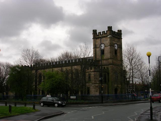
| Grimshaw Entries in Parish Records of St Michael and All Angels Church, Ashton-under-Lyne |
Grimshaw records at St Michael and All Angels Church include 129 baptisms and 49 marriages. Click here for St Michael and All Angels Church entries. A photo of St Michael and All Angels Church appears below, followed by the Wikipedia description of the Ashton under Lyne, where the church is located.
The Wikipedia entry on Ashton-under-Lyne is as follows:
Ashton-under-Lyne
From Wikipedia, the free encyclopedia
Ashton-under-Lyne (pop. 43,200) is a market town in the Metropolitan Borough of Tameside, Greater Manchester, England.[1] Historically a part of Lancashire, it lies on the north bank of the River Tame, on undulating land at the foothills of the Pennines. Ashton (as it is often shortened to) is 3.8 miles (6.1 km) south-southeast of Oldham, 6.1 miles (9.8 km) north-northeast of Stockport, and 6.2 miles (10.0 km) east of the city of Manchester.
Evidence of Stone Age, Bronze Age, and Viking activity has been discovered in Ashton-under-Lyne and its surrounding area. The "Ashton" part of the town's name probably dates from the Anglo-Saxon period, and derives from Old English meaning "settlement by ash trees". The origin of the "under-Lyne" suffix is less clear,[2] and it possibly derives from the British lemo meaning elm or from Ashton's proximity to the Pennines.[3] During the Middle Ages, Ashton-under-Lyne formed a parish and township centred on Ashton Old Hall which was held by the de Asshetons, the Lords of the Manor. Granted a Royal Charter in 1414, the manor spanned a broad rural area consisting of marshland, moorland, and a number of villages and hamlets.
Until the introduction of the cotton trade in 1769, Ashton was considered "bare, wet, and almost worthless".[3] The factory system, and textile manufacture during the Industrial Revolution triggered a process of unplanned urbanisation in the area, and by the mid-19th century Ashton had emerged as an important mill town at a convergence of newly constructed canals and railways. Ashton-under-Lyne's transport network allowed for an economic boom in cotton spinning, weaving, and coal mining, which led to the granting of honorific borough status in 1847.
During the mid-20th century, imports of cheaper foreign goods led to the decline of Ashton's heavy industries, but the town has continued to thrive as a centre of commerce, and is "considered the hub of Tameside, providing the perfect setting for the town hall, council offices and 19th-century market hall".[4] Ashton Market is one of the largest outdoor markets in the United Kingdom. The 140,000-square-foot (13,000 m2), two-floored Ashton Arcades shopping centre opened in 1995, and in 2006 IKEA opened what was then the tallest store in the country.
History
Evidence of prehistoric activity in the area comes from Ashton Moss
– a 107-hectare (260-acre) peat bog – and is the only one of Tameside's 22 Mesolithic sites not located in the hilly uplands in the north east of the borough. A single Mesolithic flint tool has been discovered in the bog,[5][6] along with a collection of nine Neolithic flints.[7] There was further activity in or around the bog in the Bronze Age. In about 1911, an adult male skull was found in the moss; it was thought to have belonged to the Romano-British period – similar to the Lindow Man bog body – until radiocarbon dating revealed that it dated from 1,320–970 BC.[8][9]The eastern terminus of the early medieval linear earthwork Nico Ditch is in Ashton Moss (grid reference SJ909980); it was probably used as an administrative boundary and dates from the 8th or 9th century. Legend claims it was built in a single night in 869–870 as a defence against Viking invaders.[10][11] Further evidence of Dark Age activity in the area comes from the town's name. The "Ashton" part probably derives from the Anglo-Saxon meaning "settlement by ash trees",[12][13] the origin of the "under-Lyne" element is less clear: it could derive from the British lemo meaning elm, or may refer to Ashton being "under the line" of the Pennines.[2][3] This means that Ashton probably became a settlement some time after the Romans left Britain in the 5th century.[14] An early form of the town's name, which included a burh element, indicates that in the 11th century Ashton-under-Lyne and Bury were two of the most important towns in Lancashire.[15] The "under-Lyne" suffix was not widely used until the mid-19th century when it became useful for distinguishing the town from other places called Ashton.[16]
The Domesday Survey of 1086 does not directly mention Ashton, perhaps because only a partial survey of the area had been taken.[17][18] However, it is thought that St Michael's Church, mentioned in the entry for the ancient parish of Manchester in the Domesday Survey, was in Ashton. The town itself was first mentioned in the 12th century when the manor was part of the barony of Manchester.[17] By the late 12th century, a family who adopted the name Assheton held the manor on behalf of the Barons of Manchester.[19] Ashton Old Hall was a manor house, the administrative centre of the manor, and the seat of the Assheton family.[20] With three wings, the hall was "one of the finest great houses in the North West" of the 14th century and antiquarian John Aikin described it as "a building of great antiquity".[20] It has been recognised as important for being one of the few great houses in south-east Lancashire and possibly one of the few halls influenced by French design in the country.[20] The town was granted a Royal Charter in 1414, which allowed it to hold a fair twice a year, and a market on every Monday,[21][22] making the settlement a market town.[23]
According to popular tradition, Sir Ralph de Assheton, who was Lord of the Manor in the mid-14th century and known as the Black Knight, was an unpopular and cruel lord. After his death, his unpopularity led the locals to parade an effigy of him around the town each Easter Monday and collect money.[24] Afterwards the effigy would be hung up, shot, and set on fire, before being torn apart and thrown into the crowd.[25] The first recorded occurrence of the event was in 1795, although the tradition may be older;[26] it continued into the 1830s.[27]
The manor remained in the hands of the Assheton family until 1514 when the line ended; Sir George Booth later acquired the manor and it descended with the Booth family until 1758 when the Earls of Stamford inherited it through marriage. The earls held the manor until the 19th century.[28] The lords' consistent absence was probably the stimulus for Ashton's growth of a large-scale domestic-based textile industry in the 17th century.[29] Pre-industrial Ashton-under-Lyne was centred around four roads: Town Street, Crickets Lane, Old Street, and Cowhill Lane. In the late-18th and early-19th centuries, the town was re-planned, with a grid pattern of roads. As a result, very little remains of the previous town.[23] In 1730 a workhouse was established which consisted of a house and two cottages; it later came to be used as a hospital.[30] The Ashton Canal was constructed in the 1790s to transport coal from the area to Manchester, with a branch to the coal pits at Fairbottom.[31]
Following the Industrial Revolution, Ashton became a mill town at the centre of a network of canals and railways.
Ashton's town library was built in the second half of the 19th century.
Domestic fustian and woollen weaving have a long history in the town, dating back to at least the Early Modern period. Accounts dated 1626 highlight that Humphrey Chetham had dealings with cloth-makers in Ashton-under-Lyne.[32] However, the introduction of the factory system in the 19th century, during the Industrial Revolution, changed Ashton from a market town to a mill town. Having previously been one of the two main towns in the Tame Valley, Ashton-under-Lyne became one of the "most famous mill towns in the North West".[33] From 1773 to 1905, 75 cotton mills were established in the town. On his tour of northern England in 1849, Scottish publisher Angus Reach said:
In Ashton, too, there lingers on a handful of miserable old men, the remnants of the cotton hand-loom weavers. No young persons think of pursuing such an occupation. The few who practice it were too old and confirmed in old habits, when the power-loom was introduced, to be able to learn a new way of making their bread.[34]
—Angus Reach , Morning Chronicle, 1849
The cotton industry in the area grew rapidly from the start of the 19th century until the Lancashire Cotton Famine of 1861–1865.[35] The growth of the town's textile industry led to the construction of estates specifically for workers. Workers' housing in Park Bridge, on the border between Ashton and Oldham, was created in the 1820s.[36] The iron works were founded in 1786 and were some of the earliest in the north west.[37] The Oxford Mills settlement was founded in 1845 by local industrialist and mill-owner Hugh Mason[38] who saw it as a model industrial community.[16] The community was provided with a recreational ground, a gymnasium, and an institute containing public baths, a library, and a reading room.[39] Mason estimated that establishing the settlement cost him around £10,000 and would require a further £1,000 a year to maintain (about £600,000 and £60,000 respectively as of 2010), and that its annual mortality rate was significantly lower than in the rest of the town.[40][41]
A poor supply of fresh water and dwellings without adequate drainage led to a cholera outbreak in the town in 1832.[42] The Ashton Poor Law Union was established in 1837 and covered most of what is now Tameside. A new workhouse was built in 1850 which provided housing for 500 people. It later became part of Tameside General Hospital.[30] Construction on the Sheffield, Ashton-under-Lyne and Manchester Railway (SA&MR) began in 1837 to provide passenger transport between Manchester and Sheffield. Although a nine-arch viaduct in Ashton collapsed in April 1845, the line was fully opened on 22 December 1845. The SA&MR was amalgamated with the Sheffield and Lincolnshire Junction Railway, the Great Grimsby & Sheffield Railway, and the Grimsby Docks Company in 1847 to form the Manchester, Sheffield and Lincolnshire Railway (MS&LR).[43] In 1890, the MS&LR bought the Old Hall and demolished it to make way for the construction of new sidings.[20]
In the late 19th century, public buildings such as the market hall, the town hall, the public library, and public baths were built.[38] A donation from Hugh Mason funded the construction of the baths constructed in 1870–1871.[44] The Ashton-under-Lyne Improvement Act was passed in 1886 which gave the borough influence over housing and allowed the imposition of minimum standards such as drainage.[45] Coal mining not as important to the town as the textile industry, but in 1882 the Ashton Moss Colliery had the deepest mine shaft in the world at 870 metres (2,900 ft).[46] Ashton's textile industry remained constant between 1865 and the 1920s. Although some mills closed or merged, the number of spindles in use increased.[35][47] With the collapse of the overseas market in the 1920s, the town's cotton industry went into decline, and by the 1930s most of the firms and mills in the area had closed.[35]
Ashton became a part of the newly formed Metropolitan Borough of Tameside in 1974.[48] In May 2004, a massive fire ravaged the Victorian market hall, and a temporary building called "The Phoenix Market Hall" was built on Old Cross Street on the opposite side of the old market hall.[49] Described as the "heart of Ashton", the market was rebuilt and officially opened on 1 December 2008.[50]
Governance
Lying within the historic county boundaries of Lancashire since the early 12th century, Ashton-under-Lyne anciently constituted a "single parish-township", but was divided into four divisions (sometimes each styled townships): Ashton Town, Audenshaw, Hartshead, and Knott Lanes.[1][51][52] Ashton Town was granted a Royal Charter in 1414, making it a market town. All four divisions lay within the hundred of Salford, an ancient division of the county of Lancashire.[1]
In 1827, police commissioners were established for Ashton Town, tasked with bringing about social and economic improvement.[1] In 1847, this area was incorporated under the Municipal Corporations Act 1835, as a municipal borough with the name "Ashton-under-Lyne", giving it borough status.[1][53] When the administrative county of Lancashire was created by the Local Government Act 1888, the borough fell under the newly created Lancashire County Council.[1] The borough's boundaries changed during the late 19th century through small exchanges of land with the neighbouring districts of Oldham, Mossley, Dukinfield, and Stalybridge.[1] In the early 20th century, the Borough of Ashton-under-Lyne grew; Hurst Urban District was added in 1927, parts of Hartshead and Alt civil parishes in 1935, and parts of Limehurst Rural District in 1954. Since 1956, Ashton has been twinned with Chaumont, France.[54]
Under the Local Government Act 1972, the town's borough status was abolished, and Ashton has, since 1 April 1974, formed part of the Metropolitan Borough of Tameside, within the metropolitan county of Greater Manchester.[1] Ashton-under-Lyne is divided into four wards: Ashton Hurst, Ashton St. Michaels, Ashton St Peters and Ashton Waterloo. As of the 2008 local elections, Ashton has ten Labour and two Conservative councillors.[55]
Since the Reform Act 1832 the town has been represented in Parliament as part of the Ashton-under-Lyne parliamentary constituency. During its early years the constituency was represented in the House of Commons by members of the Liberal Party until the late 19th century, when it was broadly held by the Conservative Party. It has been held by the Labour Party since 1935; the member of parliament as of 2009 is David Heyes.[56]
Geography
Further information: Geography of Greater Manchester
At 53°29′38″N 2°6′11″W (53.4941°, −2.1032°), and 160 miles (257 km) north-northwest of London, Ashton-under-Lyne stands on the north bank of the River Tame, about 35 feet (11 m) above the river.[2] Described in Samuel Lewis's A Topographical Dictionary of England (1848) as situated on "on a gentle declivity",[2] Ashton-under-Lyne lies on undulating ground by the Pennines, reaching a maximum elevation of about 1,000 feet (305 m) above sea level. It is 6.2 miles (10.0 km) east of Manchester city centre, and is bound on all sides by other towns: Audenshaw, Droylsden, Dukinfield, Mossley, Oldham and Stalybridge, with little or no green space between them. Ashton experiences a temperate maritime climate, like much of the British Isles, with relatively cool summers and mild winters.
Generally the bedrock of the west of the town consists of coal measures, which were exploited by the coal mining industry, while the east is mainly millstone grit. Overlying the bedrock are deposits of glacial sand and gravel, clay, and some alluvial deposits. Ashton Moss, a peat bog, lies to the west of the town and was originally much larger.[57] The River Tame forms part of the southern boundary, dividing the town from Stalybridge and Dukinfield, and the River Medlock runs to the west. The Peak Forest Canal terminates at Dukinfield Junction on the Ashton Canal, which passes through the town.
Ashton's built environment is similar to the urban structure of most towns in England, consisting of residential dwellings centred around a market square and high street in the town centre, which is the local centre of commerce. There is a mixture of low-density urban areas, suburbs, semi-rural and rural locations in Ashton-under-Lyne, but overwhelmingly the land use in the town is residential; industrial areas and terraced houses give way to suburbs and rural greenery as the land rises out of the town in the east. The older streets are narrow and irregular, but those built more recently are spacious, lined by "substantial and handsome houses".[2] Areas and suburbs of Ashton-under-Lyne include Ashton Moss, Cockbrook, Hartshead, Hazelhurst, Heys, Hurst, Limehurst, Luzley, Park Bridge, Ryecroft, Taunton, and Waterloo.
Demography
As of the 2001 UK census, Ashton-under-Lyne had a population of 43,236.[60] The 2001 population density was 12,374 per mi² (4,777 per km²), with a 100 to 96.1 female-to-male ratio.[61] Of those over 16 years old, 30.9% were single (never married) and 50.0% married.[62] Ashton-under-Lyne's 18,347 households included 33.2% one-person, 33.0% married couples living together, 8.9% were co-habiting couples, and 12.4% single parents with their children; these figures were similar to those of Tameside, however both Tameside and Ashton have higher rates of single parents than England (9.5%).[63] Of those aged 16–74, 37.0% had no academic qualifications, similar to that of 35.2% in all of Tameside but significantly higher than the 28.9% in all of England,[59][64] and 11.9% had an educational qualification such as first degree, higher degree, qualified teacher status, qualified medical doctor, qualified dentist, qualified nurse, midwife, health visitor, etc. compared to 20% nationwide.[59][65]
In 1931, 10.2% of Ashton's population was middle class compared with 14% in England and Wales, and by 1971, this had increased steadily to 17.3% compared with 24% nationally. In the same time frame, there was the decline of the working class population. In 1931, 33.8% were working class compared with 36% in England and Wales; by 1971, this had decreased to 29.2% in Ashton and 26% nationwide. The rest of the population was made up of clerical workers and skilled manual workers.[66]
Population change
In 1700, the population of Ashton-under-Lyne, the Tame Valley's main urban area, was an estimated 550. The town's 18th-century growth was fuelled by an influx of people from the countryside attracted by the prospect of work in its new industries, mirroring the rest of the region.[67] In the early 19th century, Irish immigrants escaping from the Great Irish Famine were also drawn to the area by the new jobs created,[68][69] The availability of jobs created by the growth of the textile industry in the town led to Ashton's population increasing by more than 400% between 1801 and 1861, from 6,500 to 34,886. The population dropped by 9% during the 1860s as a consequence of the cotton famine caused by the American Civil War.[70] The table below details the population change since 1851, including the percentage change since the last census.
Religion
St Michael and All Angels' Church is a Grade I listed building.
St Michael and All Angels' Church is a Grade I listed building that dates back to at least 1262, although it was rebuilt in the 15th, 16th and 19th centuries.[73] In 1795 it was the only church in the town, and one of only two in Tameside. There was a great increase in the number of chapels and religious buildings in the area during the 19th century, and by the end of the century there were 44 Anglican churches and 138 chapels belonging to other denominations. The most common denomination amongst the chapels were Catholic, Congregationalist, and Methodist.[74]
The 19th-century evangelist John Wroe attempted to turn Ashton-under-Lyne into a "new Jerusalem". He founded the Christian Israelite Church, and from 1822 to 1831 Ashton-under-Lyne was the religion's headquarters. Wroe intended to build a wall around the town with four gateways, and although the wall was never constructed, the four gatehouses were. Popular opinion in the town turned against Wroe when he was accused of indecent behaviour in 1831, but the charges were dismissed. The Church spread to Australia, where it is still active.[75][76]
As of the 2001 UK census, 68.5% of Ashton residents reported themselves as being Christian, 6.1% Muslim, 5.0% Hindu, and 0.2% Buddhist. The census recorded that 11.4% had no religion, 0.2% had an alternative religion, and 8.7% did not state their religion.[77] The proportion of Hindus in the town was much higher than the average for the borough and the whole of England 1.4% and 1.1% respectively. The percentage of Muslims in Ashton-under-Lyne was nearly double the national average of 3.1%, and was higher than the average of 2.5% for Tameside.[78] The Markazi Jamia Mosque is based in the town.[79]
Economy
IKEA's store in Ashton-under-Lyne, which opened in 2006, was their first in a town centre.
In the medieval period, farming was important in Ashton, particularly arable farming.[82] By the 18th century, textiles had also become more to the town's economy; in the 1700s, 33.2% of those with jobs worked in textiles and 36% in agriculture.[83] With the advent of the Industrial Revolution in the second half of the 18th century, the textile industry in the town boomed. It continued to expand until the cotton famine of 1861–1865, after which the industry was steady until it collapsed after the overseas markets shut down in the 1920s.[84]
Coal has been mined in Ashton since at least the 17th century.[85] In the late 18th and early 19th centuries demand for coal increased, which led to an expansion of the town's coal industry. The produce of the collieries was transported by canal to Manchester.[46] The industry began to decline during the late 19th century, and by 1904 only the Ashton Moss Colliery was still operational, the last colliery to be opened in the area.[46]
Ashton town centre, which is the largest in Tameside, developed in the Victorian period. Many of the original buildings have survived, and as a result, the town centre is protected by Tameside Council as a conservation area.[22][86] As well as being populated by leading high-street names, Ashton has an outdoor market which was established in the medieval period. It is made up of about 180 stalls, and is open six days a week.[22] The farmers' market, with over 70 stalls, is the largest in the region, as is the weekday flea market.[87] Ashton Market Hall underwent a £15M restoration after it was damaged by fire. The Ashton Renewal Area project has attracted investment in the town centre, encouraging conservation and economic development.[22]
The 140,000-square-foot (13,000 m2), two-floored Ashton Arcades shopping centre opened in 1995. Permission has been granted for a £40 million extension and is expected to open in autumn 2009.[88] In 2006, after failing twice to gain permission, IKEA announced plans to build its first town centre-store in Ashton-under-Lyne. The store is expected to create 500 new jobs as well as attract other businesses to the area.[89] The store opened on 19 October 2006 and covers 296,000 square feet (27,500 m2). At the time of its creation, the store was the tallest in Britain.[90]
Amongst the facilities provided by Ashton Leisure Park are a 14-screen cinema, a bowling alley, and several restaurants.[91] The St Petersfield area of Ashton underwent a £42M redevelopment and provided 2,000 jobs. The aim of the investment was to create a business district in the town and bring life to a neglected area of Ashton. The development provided 280,000 square feet (26,000 m2) of office space and 400,000 square feet (37,000 m2) of retail and leisure space.[92] Pennine Care NHS Trust relocated its headquarters to the St Petersfield area in 2006.[93] Until then a popular nightspot, in 2002 several night clubs were brought to the brink of closure after a downturn in trade caused by four murders in three months.[94]
According to the 2001 UK census, the industry of employment of residents aged 16–74 was 22.7% manufacturing, 18.6% retail and wholesale, 11.3% health and social work, 9.8% property and business services, 6.7% construction, 6.5% transport and communications, 5.8% education, 5.6% public administration, 4.3% hotels and restaurants, 3.8% finance, 0.4% agriculture, 0.7% energy and water supply, and 3.9% other. Compared with national figures, the town had a relatively low percentage working in agriculture, public administration, and property which was also below the national average, and high rates of employment in construction at more than triple the national rate (6.8%).[95] The census recorded the economic activity of residents aged 16–74, 2.0% students were with jobs, 3.8% students without jobs, 6.4% looking after home or family, 9.5% permanently sick or disabled, and 3.9% economically inactive for other reasons.[80] Ashton's 4.1% unemployment rate was above the national rate of 3.3%.[81]
Culture
Sports
The most prominent football teams are Ashton United F.C. and Curzon Ashton F.C. Of the teams who formed the Manchester Football Association Ashton United, under the name Hurst, were the first to win an FA Cup tie, when they beat Turton 3–0 in 1883. In 1885 they were the first winners of the Manchester Cup, beating Newton Heath (who later became Manchester United) in the final.[96] Ashton United play at Hurst Cross stadium and Curzon Ashton at the Tameside stadium on Richmond Street. The Richmond Park Athletics Stadium, also on Richmond Street, has an all-weather running track with facilities for all field events[97] and is home to the East Cheshire Harriers & Tameside Athletics Club and the Ashton Cricket Club. This team has won the Central Lancashire Cricket League's first and second division twice each, and the Wood Cup, four times.[98]
Landmarks
After the Ashton Canal closed in the 1960s, it was decided to turn the Portland Basin warehouse into a museum. In 1985, the first part of the Heritage Centre and Museum opened on the first floor of the warehouse.[99] The restoration of building was complete in 1999; the museum details Tameside's social, industrial, and political history.[100] The basin next to the warehouse is the point at which the Ashton Canal, the Huddersfield Narrow Canal and the Peak Forest Canal meet. It has been used several times as a filming location for Coronation Street, including a scene where the character Richard Hillman drove into the canal.[101]
The earliest parts of Ashton Town Hall, which was the first purpose-built town hall in what is now Tameside, date to 1840 when it was opened. It has classical features such as the Corinthian columns on the entrance facade. Enlarged in 1878, the hall provides areas for administrative purposes and public functions.[102] It is a Grade II listed building.[103] After the Ashton-under-Lyne municipal borough was abolished in 1974, the town hall was no longer required and became the home of the Museum of the Manchester Regiment. The museum exhibits relics related to the Manchester Regiment including five Victoria Crosses awarded to its members.[104]
Over 60,000 people turned out to the opening of Stamford Park in 1873; it had taken 17 years of campaigning and fundraising by local cotton workers
There are five parks in the town, three of which have Green Flag Awards.[105] The first park opened in Ashton-under-Lyne was Stamford Park on the border with Stalybridge. The park opened in 1873, following a 17 year campaign by local cotton workers;[106] the land was bought from a local mill-owner for £15,000 (£1 million as of 2010)[107] and further land was donated by George Grey, 7th Earl of Stamford.[108] A crowd of between 60,000 and 80,000 turned out to see the Earl of Stamford formally open the new facility on 12 July 1873. It now includes a boating lake, and a memorial to Joseph Rayner Stephens, commissioned by local factory workers to commemorate his work promoting fair wages and improved working conditions. A conservatory was opened in 1907, and Coronation gates installed at both the Ashton-under-Lyne and Stalybridge entrances in 1953.[106]
Hartshead Pike is a stone tower on top of Hartshead Hill overlooking Ashton and Oldham.[109] The current building was constructed in 1863 although there has been a building on the site since at least the mid-18th century, although the original purpose is obscure. The pike may have been the site of a beacon in the late 16th century.[110] It has a visitor centre and from the top of the hill it is possible to see the Jodrell Bank Observatory in Cheshire, the Welsh hills, and the Holme Moss transmitter in West Yorkshire.[111]
The Witchwood public house, in the St Petersfield area of the town, has been a music venue since the 1960s, hosting acts such as Muse, The Coral, and Lost Prophets.[112] In 2004 The Witchwood came under threat when the area was being redeveloped, but was saved from demolition after a campaign by locals and led by Tom Hingley, drawing support from musicians such as Bert Jansch, The Fall, and The Chameleons.[113]
The main Ashton-under-Lyne War Memorial, in Memorial Gardens, consists of a central cenotaph on plinth, surmounted by sculpted wounded soldier and the figure of "Peace who is taking the sword of honour" from his hand.[114] It commemorates the 1,512 people from the town who died in the First World War and the 301 who died in the Second World War.[115] The cenotaph is flanked on both sides by two bronze lions. The plinth is decorated with military equipment representing the services, as well as bronze tablets listing the Roll of Honour from World War I. Commissioned by the Ashton War Memorial Committee, the statue was sculpted between 1919 and 1922 by John Ashton Floyd, and unveiled on 16 September 1922 by General Sir Ian Hamilton.[114]
The tablet on the front of the memorial reads:
Erected in honour of the men of Ashton-under-Lyne and district who fought for King and Empire in The Great War, especially those who sacrificed their lives, and whose names are recorded hereon
1914–1919[114]
Transport
In 1732, an Act of Parliament was passed which permitted the construction of a turnpike from Manchester, then in Lancashire, to Salters Brook in Cheshire. The road passed through Ashton-under-Lyne as well as Audenshaw, Mottram-in-Longdendale, and Stalybridge. A Turnpike Trust was responsible for collecting tolls from traffic; the proceeds were used for road maintenance. The Trust for Manchester to Salters Brook was one of over 400 established between 1706 and 1750, a period in which turnpikes became popular.[116] It was the first turnpike to be opened in Tameside, and driven by economic growth, more turnpikes were opened in the area in the late 18th and early 19th centuries. Acts of Parliaments were passed in 1765, 1793, and 1799 permitting the construction turnpikes from Ashton-under-Lyne to Doctor Lane Head in Saddleworth, Standedge in Saddleworth, and Oldham respectively. Towards the end of the 19th century, many Turnpike Trusts were wound up as they were superseded by local government; the last in Tameside to close was the Ashton-under-Lyne to Salters Brook road in 1884.[117]
The town of Ashton-under-Lyne became the focus of three canals which were constructed in Tameside in the 1790s because it was an important centre of coal mining in the Lancashire coalfield. The 1790s has been characterised as a period of mania for canal building in England. The first of the three to be built was the Ashton Canal, which was constructed between 1792 and 1797. Connecting Manchester to Ashton-under-Lyne, with a branch to Oldham, it cost about £170,000 (£13 million as of 2010).[107][118] The Peak Forest Canal was constructed from 1794 to 1805, and was originally planned as a branch of the Ashton Canal. It connected the Portland Basin with the Peak District and cost £177,000 (£11 million as of 2010).[107][119] The Huddersfield Narrow Canal was built between 1794 and 1811, to enable cross-Pennine trade between Manchester and Kingston upon Hull; the cost of construction was £400,000.[107][119]
The advent of the railways in the 19th century signalled the decline of the canal system. The Sheffield, Ashton-under-Lyne and Manchester Railway Company was founded in 1836 with the purpose of building a line linking Manchester and Sheffield. The line was opened in stages and by 1845 was complete. It included a branch to the nearby town of Stalybridge.[43] The new railways were quicker and more economical than the canals, and the waterways declined. The Huddersfield Canal was bought by the Huddersfield and Manchester Railway in 1844. Along with the Ashton and Peak Forest canals, the Huddersfield canal was later bought by the Sheffield, Ashton-under-Lyne and Manchester Railway Company.[120] The company was amalgamated with the Sheffield and Lincolnshire Junction Railway and the Great Grimsby and Sheffield Junction Railway in 1847 to become the Manchester, Sheffield and Lincolnshire Railway Company.[43] The canals remained in use throughout the 19th century on a smaller scale than in their heyday, but by the mid-20th century all commercial traffic had ceased. They were used for leisure craft and are still maintained and in good condition.[121]
In 1881, a tramway with horse-drawn tramcars was opened between Stalybridge and Audenshaw, through Ashton-under-Lyne. The first tramway of its kind in Tameside, it was later extended to Manchester. The Oldham, Ashton and Hyde Electric Tramway Company, founded in 1899, operated 13 km (8 mi) of tram lines with electric tramcars. It was the first line around Manchester to use electricity. A line from Stalybridge to Ashton-under-Lyne was opened in 1903 and operated by the Stalybridge, Hyde, Mossley and Dukinfield Tramways and Electricity Board.[122] The first bus service from Ashton-under-Lyne ran in 1923 and the 1920s saw a period of decline for the tramways as they suffered from the competition from buses. The last electric tram service in the town ran in 1938.[123]
The M60 motorway cuts through the west end of Ashton (Junction 23). Regular rail services on the Huddersfield Line between Manchester (Victoria) and Huddersfield stop at Ashton-under-Lyne railway station in the town centre. An extension of the Manchester Metrolink to Ashton will now go ahead, paid for through the Greater Manchester Transport Fund, after previous funding difficulties.[124] Ashton also has one of the busiest bus stations in Greater Manchester. It is planned to be developed and extended in the coming years. Many buses from Ashton go to the surrounding areas of Tameside, including Mossley, Stalybridge, Droylsden, Hyde and Dukinfield. There are also services to many parts of Manchester city centre, and also to many parts of Oldham including Saddleworth, Oldham itself, Royton, Shaw and Rochdale.
Education
There are eight nursery schools,[125] fifteen primary schools,[126] and two secondary schools in Ashton-under-Lyne.[127] In 2006, the council began a scheme to develop education in the borough by opening six new secondary schools. Among the changes proposed as part of the £160M scheme was the closure of Hartshead Sports College and Stamford Community High School, to be replaced by a 1,350-pupil academy with 300 members of sixth form. The new academy was named New Charter after its sponsor, the New Charter Housing Trust. In 2007, Hartshead Sports College was placed on "special measures" after it failed to achieve its targets for General Certificate of Secondary Education results and was criticised by Ofsted for its teaching standard.[128] Originally expected to open in September 2009,[129] the academy opened in September 2008.[130] It is the only academy in Tameside, and one of seven in Greater Manchester.[131]
The other secondary school in the town is St Damian's Science College, which provides education for 800 pupils aged 11–16.[132] Dale Grove School has 60 students and offers education for pupils aged 5–16 with special needs.[133] Ashton-under-Lyne Sixth Form College is a centre for further education with 1,650 pupils aged 16–18.[134] Tameside College also provides opportunities for further education and operates in Ashton-under-Lyne, Droylsden, and Hyde.[135] Founded in 1954 and expanded in 1957 and 1964, it was originally called Ashton College.[136]
Public services
In the early 19th century, Ashton-under-Lyne's growth made it necessary to find a new water supply. Before the introduction of piped water the town's inhabitants drew water from wells and the nearby River Tame. Industrial processes had polluted the river however, and the wells could not sustain a rapidly expanding population. From 1825, a private company was responsible for piping water from reservoirs, but there were still many homes without proper drainage or water supply.[42] Today, waste management is co-ordinated by the local authority via the Greater Manchester Waste Disposal Authority.[137] The first power station in Tameside was built in 1899, providing power for the area.[138] Ashton's Distribution Network Operator for electricity is United Utilities;[139] there are no power stations in the town. United Utilities also manages the drinking and waste water.[139]
Home Office policing in Ashton-under-Lyne is provided by the Greater Manchester Police. The force's Tameside Division have their divisional headquarters for policing Tameside in the town.[140][141] Public transport is co-ordinated by the Greater Manchester Passenger Transport Executive. Statutory emergency fire and rescue service is provided by the Greater Manchester Fire and Rescue Service, which has one station on Slate Lane.[142] The Tameside General Hospital is a large NHS hospital on the outskirts of the town,[143] administrated by Tameside Hospital NHS Foundation Trust.[144] The North West Ambulance Service provides emergency patient transport. Other forms of health care are provided for locally by several small clinics and surgeries.
Notes
1. ^ a b c d e f g h A select gazetteer of local government areas, Greater Manchester County, Greater Manchester County Record Office, 2003-07-31, retrieved 2008-09-20
^ a b c d e Lewis (1848) pp. 90–96.
^ a b c Wilson (1870–1872).
^ Greater Manchester Police (2006-01-25), Ashton, gmp.police.uk, retrieved 2008-09-19
^ Nevell (1992), p. 25.
^ Nevell (1992), p. 11.
^ Nevell (1992), p. 30.
^ Nevell (1992), p. 71.
^ Hodgson & Brennand (2004), p. 44.
^ Nevell and Walker (1998), pp. 40–41.
^ Nevell (1992), pp. 77–83.
^ Nevell (1997), p. 32.
^ University of Nottingham's Institute for Name-Studies, Ashton-under-Lyne, nottingham.ac.uk, retrieved 2008-09-18
^ Nevell (1992), pp. 84–85.
^ Nevell (1992), p. 88.
^ a b Township Information — Ashton, Tameside.gov.uk, retrieved 2008-09-12
^ a b Nevell (1991), p. 17.
^ Redhead, Norman, in: Hartwell, Hyde and Pevsner (2004), p. 18.
^ Nevell and Walker (1998), p. 47.
^ a b c d Nevell and Walker (1998), p. 54.
^ Nevell (1991), p. 60.
^ a b c d Ashton-under-Lyne town centre, Tameside.gov.uk, retrieved 2008-09-13
^ a b Nevell (1993), p. 146.
^ Griffith (1898), p. 380.
^ Griffith (1898), p. 381.
^ The Black Knight Pageant, Ashton-under-Lyne.com, retrieved 2008-09-20
^ Griffith (1898), pp. 379, 382.
^ Nevell and Walker (1998), p. 48.
^ McNeil & Nevell (2000), p. 54.
^ a b Burke and Nevell (1996), p. 123.
^ Nevell (1993), p. 99.
^ Frangopulo (1977), p. 25.
^ McNiel and Nevell (2005), p. 54.
^ Powell (1986), p. 35.
^ a b c Nevell (1993), p. 35.
^ Nevell and Walker (1999), p. 49.
^ Nevell and Roberts (2003), pp. 19, 22, 31–32.
^ a b Nevell (1993), p. 151.
^ Nevell (1993), p. 152.
^ Nevell (1994), pp. 44–45.
^ Currency converter, NationalArchives.gov.uk, retrieved 2008-09-12
^ a b Nevell (1993), p. 132.
^ a b c Nevell (1993), p. 127.
^ Nevell (1993), p 23.
^ Nevell (1993), pp. 149–151.
^ a b c Nevell (1993), p. 102.
^ Nevell (1993), p. 37.
^ Nevell (1993), p. iii.
^ Sue Carr (2004-10-21), "Ashton celebrates as new market opens its doors", Tameside Advertiser, retrieved 2008-09-18
^ Sue Carr (2008-12-01), "Joy as market hall opens", Tameside Advertiser, retrieved 2009-07-10
^ Farrer & Brownbill (1911), pp. 338–347.
^ A vision of Ashton under Lyne AP/CP, visionofbritain.org.uk, retrieved 2008-09-19
^ A vision of Britain through time, A vision of Ashton under Lyne MB, retrieved 2007-06-03
^ Tameside Metropolitan Borough Council (2006-09-27), Town twinning, Tameside.gov.uk, retrieved 2008-09-04
^ Tameside Metropolitan Borough Council, Know you councillor, Tameside.gov.uk, retrieved 2008-09-15
^ Ashton under Lyne, The Guardian, retrieved 2009-09-03
^ Nevell (1992), pp.10–11.
^ KS06 Ethnic group: Census 2001, Key Statistics for urban areas, Statistics.gov.uk, 2005-01-25, retrieved 2008-08-05
^ a b c Tameside Metropolitan Borough key statistics, Statistics.gov.uk, retrieved 2008-09-12
^ (PDF) Tameside Census Snapshot, Tameside MBC, 2004, retrieved 2008-01-17
^ KS01 Usual resident population: Census 2001, Key Statistics for urban areas, Statistics.gov.uk, 2005-02-07, retrieved 2008-09-12
^ KS04 Marital status: Census 2001, Key Statistics for urban areas, Statistics.gov.uk, 2005-02-02, retrieved 2008-09-12
^ KS20 Household composition: Census 2001, Key Statistics for urban areas, Statistics.gov.uk, 2005-02-02, retrieved 2008-09-12
• Tameside Metropolitan Borough household data, Statistics.gov.uk, retrieved 2008-09-12
^ KS13 Qualifications and students: Census 2001, Key Statistics for urban areas, Statistics.gov.uk, 2005-02-02, retrieved 2008-09-12
^ KS13 Qualifications and students: Census 2001, Key Statistics for urban areas, 2005-02-07, retrieved 2008-09-12
^ Ashton under Lyne social class, Vision of Britain, retrieved 2008-09-15
• Percentage of Working-Age Males in Class 1 and 2, Vision of Britain, retrieved 2008-09-15
• Percentage of Working-Age Males in Class 4 and 5, Vision of Britain, retrieved 2008-09-15
^ Nevell (1993), p. 168.
^ Nevell (1993), p. 27.
^ The Murphy Riots in Ashton under Lyne, Ashton-under-Lyne.com, retrieved 2007-12-09
^ Nevell (1993), p. 36.
^ Facts about Ashton, Tameside.gov.uk, retrieved 2008-09-16
^ Nevell (1993), p. 12.
^ Nevell (1991), pp. 121, 135.
^ Nevell (1993), p. 142.
^ Nevell (1994), p. 95.
^ A Tribute to Prophet Wroe 1782–1863, Tameside.gov.uk, retrieved 2009-07-10
^ KS07 Religion: Census 2001, Key Statistics for urban areas, Statistics.gov.uk, 2005-02-02, retrieved 2008-08-05
^ Tameside Metropolitan Borough key statistics, Statistics.gov.uk, retrieved 2009-07-10
^ Markazi Jamia Mosque, Yell.com, retrieved 2009-07-10
^ a b KS09a Economic activity – all people: Census 2001, Key Statistics for urban areas, Statistics.gov.uk, 2005-02-03, retrieved 2008-09-15
^ a b Tameside Local Authority economic activity, Statistics.gov.uk, retrieved 2008-09-15
^ Nevell (1991), p. 52.
^ Nevell (1993), pp. 35, 83.
^ Nevell (1993), pp. 35–39
^ Nevell (1993), p. 101.
^ Tameside Metropolitan Borough Council (November 1992), Appendix 6: Conservation Areas and Scheduled Ancient Monuments (Policies C11 and C30), Tameside.gov.uk, retrieved 2008-09-04
^ Ashton market, Tameside.gov.uk, 2007-11-03, retrieved 2008-09-20
^ David Thame (2006-06-13), "Ashton's mall on the up", Manchester Evening News, retrieved 2008-09-03
^ Ikea's superstore plans approved, BBC Online, 2006-01-11, retrieved 2008-09-03
^ Emma Unsworth (2006-10-16), "IKEA's finally here", Manchester Evening News, retrieved 2008-09-03
^ Completed development, Ashton-Moss.com, retrieved 2009-07-06
^ David Thame (2005-05-23), "The big spenders are in town!", Manchester Evening News, retrieved 2008-09-15
^ David Thame (2005-07-05), "Ashton's eastern promise", Manchester Evening News, retrieved 2008-09-15
^ Street killings hit town's night spots, Tameside Advertiser, 2002-05-23, retrieved 2008-08-20
^ KS11a Industry of employment - all people: Census 2001, Key Statistics for urban areas, Statistics.gov.uk, 2005-02-03, retrieved 2008-09-15
^ James (2008), pp. 33–34.
^ History of East Cheshire Harriers, East Cheshire Harriers, retrieved 2009-07-19
^ Oldham Cricket Club: Wood Cup, OldhamCC.co.uk, retrieved 2008-09-01
^ Nevell and Walker (2001), pp. 59, 61.
^ Nevell and Walker (2001), pp. 63–64.
^ From far-flung Canada to Corrie, Manchester Evening News, 2008-09-17, retrieved 2008-09-19
^ Burke and Nevell (1996), pp. 118–119.
^ Ashton-under-Lyne Town Hall, Images of England, retrieved 2008-09-18
^ Museum of the Manchester Regiment, culture24.org.uk, retrieved 2008-09-04
^ Parks in Tameside: Tameside Parks Moving Forward, Tameside.gov.uk, retrieved 2009-07-07
^ a b Tameside Metropolitan Borough council : Stamford Park : History Retrieved 2009-09-12
^ a b c d UK CPI inflation numbers based on data available from Measuring Worth: UK CPI.
^ Nevell (1993), p. 145.
^ Wyke (2005), p. 357.
^ Burke and Nevell (1996), pp. 144–145.
^ Hartshead Pike, Tameside.gov.uk, 2006-10-13, retrieved 2008-09-20
^ Sue Carr (2006-11-15), Save The Witchwood, TamesideAdvertiser.co.uk, retrieved 2008-04-26
^ Don Frame (2005-01-24), "Party as stars' pub is saved", Manchester Evening News, retrieved 2008-01-29
^ a b c Public Monuments and Sculpture Association (2003-06-16), Ashton-under-Lyne War Memorial, pmsa.cch.kcl.ac.uk, retrieved 2008-09-19
^ Ashton War Memorial, Tameside.gov.uk, retrieved 2009-07-10
^ Nevell (1993), pp. 118–120.
^ Nevell (1993), p. 121.
^ Nevell (1993), pp. 121–122.
^ a b Nevell (1993), p. 122.
^ Nevell (1993), pp. 123–124.
^ Nevell (1993), pp. 124–125.
^ Nevell (1993), p. 130.
^ Nevell (1993), pp. 130–131.
^ "AGMA News Release: Transport for Greater Manchester on Track", Greater Manchester Passenger Transport Executive, 2009-05-13, retrieved 2009-11-08
^ Nursery Schools List by Area, Tameside.gov.uk, retrieved 2009-06-29
^ Primary Schools List by Area, Tameside.gov.uk, retrieved 2009-06-29
^ High Schools List by Area, Tameside.gov.uk, retrieved 2009-06-29
^ Eve Dugdale (2007-02-07), School is labelled as 'inadequate', Tameside Advertiser, retrieved 2009-06-25
^ Adam Derbyshire (2006-11-22), Six super schools in vision of future, Tameside Advertiser, retrieved 2009-06-25
^ New Charter Academy admission arrangements 2010/2011, Tameside.gov.uk, retrieved 2009-06-25
^ (PDF) Academies in England – September 2008, SpecialistSchools.org.uk, retrieved 2009-06-25
^ St Damian's RC Science College, Department for Children, Schools and Families, retrieved 2009-06-29
^ Dale Grove School, Department for Children, Schools and Families, retrieved 2009-06-29
^ Ashton-under-Lyne Sixth Form College, Department for Children, Schools and Families, retrieved 2009-06-29
^ Find us – Tameside College, Tameside.ac.uk, retrieved 2009-06-29
^ Nostalgia: the 1950s, The Tameside Advertiser, 2003-10-09, retrieved 2009-06-29
^ Greater Manchester Waste Disposal Authority (2008), Greater Manchester Waste Disposal Authority (GMWDA), gmwda.gov.uk, retrieved 2008-02-08
^ Nevell (1993), pp. 134–135.
^ a b United Utilities (2007-04-17), Tameside, unitedutilities.com, retrieved 2008-09-19
^ Greater Manchester Police (2006-01-25), Your Area — Tameside, gmp.police.uk, retrieved 2008-09-19
^ Greater Manchester Police, Tameside, gmp.police.uk, retrieved 2009-07-06
^ Greater Manchester Fire and Rescue Service, Ashton-Under-Lyne Fire Station, manchesterfire.gov.uk, retrieved 2007-10-31
^ Profile, tamesidehospital.nhs.uk, retrieved 2008-09-19
^ About the Trust, tamesidehospital.nhs.uk, retrieved 2008-09-19
Bibliography
Burke, Tom; Nevell, Mike (1996), Buildings of Tameside, Tameside Metropolitan Borough and University of Manchester Archaeological Unit, ISBN 1-871324-14-9
Farrer, William; Brownbill, J (1911), The parish of Ashton-under-Lyne – Introduction, manor & boroughs, British-history.ac.uk
Frangopulo, N. J. (1977), Tradition in Action: The Historical Evolution of the Greater Manchester County, Wakefield: EP, ISBN 0-7158-1203-3
Griffith, Kate (1898), "The Black Lad of Ashton-under-Lyne", Folklore (Taylor & Francis, Ltd) 8 (4)
Hartwell, Clare; Matthew Hyde and Nikolaus Pevsner (2004), Lancashire : Manchester and the South-East, The buildings of England, New Haven, Conn.; London: Yale University Press, ISBN 0-300-10583-5
Hodgeson, John; Brennand, Mark (2004), Mark Brennand, ed., The Prehistoric Period Resource Assessment, pp. 23–58, ISSN 0962-4201
James, Gary (2008), Manchester – A Football History, Halifax: James Ward, ISBN 978-0-9558127-0-5
Lewis, Samuel (1848), A Topographical Dictionary of England, Institute of Historical Research, ISBN 978-0-8063-1508-9
McNeil, R & Nevell, M (2000), A Guide to the Industrial Archaeology of Greater Manchester, Association for Industrial Archaeology, ISBN 0-9528930-3-7
Nevell, Mike (1991), Tameside 1066–1700, Tameside Metropolitan Borough and University of Manchester Archaeological Unit, ISBN 1-871324-02-5
Nevell, Mike (1992), Tameside Before 1066, Tameside Metropolitan Borough and Greater Manchester Archaeological Unit, ISBN 1-871324-07-6
Nevell, Mike (1993), Tameside 1700–1930, Tameside Metropolitan Borough and University of Manchester Archaeological Unit, ISBN 1-871324-08-4
Nevell, Mike (1994), The People Who Made Tameside, Tameside Metropolitan Borough Council, ISBN 1-871324-12-2
Nevell, Mike (1997), The Archaeology of Trafford, Trafford Metropolitan Borough Council with the University of Manchester Archaeological Unit, ISBN 1-870695-25-9
Nevell, Mike; John Roberts (2003), The Park Bridge Ironworks and the archaeology of the Wrought Iron Industry in North West England, 1600 to 1900, Tameside Metropolitan Borough with University of Manchester Archaeological Unit, ISBN 1-871324-27-0
Nevell, Mike; Walker, John (1998), Lands and Lordships in Tameside, Tameside Metropolitan Borough Council with the University of Manchester Archaeological Unit, ISBN 1-871324-18-1
Nevell, Mike; Walker, John (2001), Portland Basin and the archaeology of the Canal Warehouse, Tameside Metropolitan Borough with University of Manchester Archaeological Unit, ISBN 1-871324-25-4
Powell, Rob (1986), In the Wake of King Cotton, Rochdale Art Gallery
Wilson, John Marius (1870–1872), Imperial Gazetteer of England and Wales, A. Fullarton & Co
Wyke, Terry (2005), Public Sculpture of Greater Manchester, Liverpool University Press, ISBN 0-85323-567-8
External links
Wikimedia Commons has media related to: Ashton-under-Lyne
Ashton-under-Lyne.com
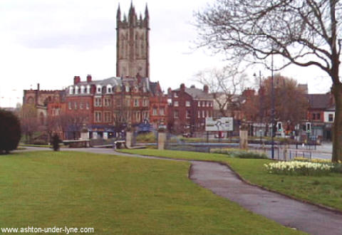
| Grimshaw Entries in Parish Records of Brookfield Unitarian (Dissenting) Church, Gorton |
Grimshaw records at Brookfield Unitarian Church include 104 baptisms and approximately 27 burials. Click here for Brookfield Unitarian (Dissenting) Church entries. A photo of Brookfield Unitarian Church appears below, followed by the Wikipedia description of the church.
Source: http://www.genuki.org.uk/big/eng/LAN/Gorton/BrookfieldChurch.shtml
The Wikipedia entry on Gorton is as follows:
Gorton
From Wikipedia, the free encyclopedia
Gorton is an area of the city of Manchester, in North West England. It is located to the southeast of Manchester city centre. Neighbouring areas include Longsight and Levenshulme.
A major landmark in Gorton is Gorton Monastery, a Franciscan 19th century High Victorian Gothic monastery.
History
Further information: History of Manchester
According to local folklore, Goreton derives its name "Gore Town" due to a battle between the Saxons and Danes nearby.[1][2] This has been dismissed by historians as "popular fancy".[3] The name Gorton means "dirty farmstead",[4] perhaps taking its name from the Gore Brook, or dirty brook, which still runs through the township to-day. The brook may have acquired that name because of the dirty appearance of its water, perhaps caused by discolouration due to peat or iron deposits.[5]
In medieval times the district was a township of the ancient parish of Manchester in the Salford Hundred of Lancashire.
Manchester City F.C. was founded as St. Mark's (West Gorton) in 1880. The Club was formed with the aim of binding the local community and to combat a form of gang warfare called Scuttling that existed during the 1870s.[6][7] The Rector's daughter Anna Connell is widely credited as the founder, however churchwarden William Beastow is believed to be the person who played the main part in creating sporting activities for the parish. In 1875 St.Mark's Cricket Club are known to have played and this evolved into the football club later in the decade.[8] The first recorded football game was played in November 1880.[9]
Railways
Gorton railway station opened in 1842. In 1849 a locomotive works was built for the Manchester, Sheffield and Lincolnshire Railway, later the Great Central Railway. It was known locally as the "Gorton Tank". It carried out repairs and major overhauls, producing new boilers and all LNER castings. There was also a carriage and wagon works which had been built in 1881 which carried out light repairs. Both were closed in 1962.[10] Gorton was also the home of the Beyer-Peacock locomotive Company at Gorton Foundry, from 1854, until it closed in 1966. One of the company's partners, Richard Peacock subsequently became Liberal M.P for Gorton in the 1885 general election.
20th century
Most of the 19th-century Victorian houses around Gorton were demolished during the 1960s, and many people were moved to new overspill housing estates in other parts of the city. However, some people remained in Gorton and were placed in new council houses and flats.
Myra Hindley grew up in Gorton.[11] She and Ian Brady lived there at the time of the first three Moors murders, before moving to Hattersley in 1964 where they committed two further murders and were arrested in October 1965. Their first victim, Pauline Reade (who died in July 1963 aged 16, but whose body was not found for 24 years), was also a Gorton resident, and was living in the same street as Myra Hindley when last seen alive.
Social problems in Gorton
In 2006 the Motor Insurers' Bureau named West Gorton as the worst place in the UK for uninsured cars, with over six times the national average of drivers living there having no cover.[12]
More recently some parts of Gorton have suffered from serious deprivation, which has resulted in high crime levels and burglary. The popular television series Shameless (UK TV series), which is shown on Channel 4 is mainly filmed in West Gorton. The parade of shops used for filming in the initial series was built on the site of St. Mark's Church, Clowes Street - the birthplace of Manchester City F.C.[13]
Governance
The municipal borough of Manchester was created in 1838 and elevated to a city in 1853. Part of Gorton township was included in the city in 1890. The remaining part of the township became an Urban District of the administrative county of Lancashire in 1894. A small part of the urban district was transferred to the city of Manchester in 1901 and the remaining area was fully incorporated into Manchester in 1909.
Gorton forms part of the Manchester Gorton parliamentary constituency. The current MP is the Rt Hon Sir Gerald Kaufman. Gorton is split into two electoral wards - Gorton North and Gorton South.
Geography
Belle Vue is a locality within Gorton. West Gorton was included in the City of Manchester in 1890, whereas the remainder of Gorton was included only in 1909, thanks largely to the work of councillor Joseph Henry Williamson, then Chairman of Gorton Urban District Council.
Landmarks
Gorton is home to Gorton Monastery, a Franciscan, 19th-century High Victorian Gothic Monastery. In recent years this has been renovated and has been secularised: it was previously derelict after the friars moved out. Also in Gorton is the Brookfield Unitarian Church on Hyde Road, built by Richard Peacock: see "Brookfield Church Memorabilia".
In 2006, Manchester City Council started a multi-million-pound redevelopment of the Gorton District Shopping Centre. The small market and retail area was demolished and work started in late 2007 to construct a brand new market hall and a new Tesco Extra hypermarket on this site. In July 2008, the new Manchester Gorton Market Hall was opened to the public. The construction of the new hypermarket and neighbouring petrol station continued, and in late October 2008 the new Tesco Extra store opened its doors for trading on 27 October 2008. Further retail outlets are to be developed near this site along Hyde Road.[citation needed]
Gorton is also home to the Greater Manchester Police, Tactical Firearms Unit based at Openshaw Police Station.
Performing arts and sport
The Gorton Philharmonic Orchestra was founded in 1854 and is an amateur orchestra.[14] The folk comedy group Gorton Tank were based in Gorton and were popular in the Manchester area. The actor John Thaw, who is perhaps best known for his role as Inspector Morse, was born in West Gorton.[15] The painter Michael Gutteridge was also born in Gorton. The Gorton Morris Men were responsible for reviving the rushcart ceremony in Gorton.[16]
Manchester City F.C. were founded as St. Mark's (West Gorton) in 1880 and many of their footballers, such as Billy Meredith and Tommy Johnson lived in the area.[17] Meredith was married at St. Mark's Church and lived on Clowes Street itself for a while. The much less notable Abbey Hey F.C. club is in Gorton; Gorton is the birthplace of former Manchester United footballer, Nicky Butt. 'Jumping Billy Barker' was a local man who specialised in jumping feats, and also invented the cinema safety-door.[18]
Notes
1. Booker (1857), p. 197.
2. ^ Harland & Wilkinson (1993), pp. 26
–29.3. ^ Farrer & Brownbill (1911), pp. 275
–279.4. ^ A ditch in time, BBC Online, 1 August 2008, retrieved 5 January 2009
5. ^ Cooper (2007), p. 80.
6. ^ James (1997), p. 9-12.
7. ^ James (2008), p. 55-64.
8. ^ James (2008), p. 55-58.
9. ^ James (1997), p. 12.
10. ^ The Gorton railway works subsequently became an engineering and test centre for the computer division of Ferranti, later ICL
11. "Murder on the Moors: The Ian Brady and Myra Hindley Story
– Crime Library".12. ^ Motor Insurers Bureau. "Manchester declared UK's Number One Uninsured Driving Hotspot - MIB press release, 18 September 2006".
13. ^ James (2008), p. 373.
14. ^ "Gorton Philharmonic Orchestra". Retrieved 2009-04-10.
15. ^ "John Thaw accessdate=2009-07-21".
16. ^ "Gorton Rushcart revival". Retrieved 2009-04-10.
17. ^ James (1997), p. 112.
18. ^ "Billy Barker". Retrieved 2009-04-10.
Bibliography
Booker, John (1857). A History of the Ancient Chapels of Didsbury and Chorlton. Manchester: Chetham Society.
Cooper, Glynis (2007). The Illustrated History of Manchester's Suburbs; updated edition. Derby: The Breedon Books Publishing Company. ISBN 9781859835920. (first published in 2002)
Farrer, W.; Brownbill, J. (editors) (1911). A History of the County of Lancaster [Victoria County History]. 4; chapter:Townships: Gorton. pp. 275
–279. http://www.british-history.ac.uk/report.aspx?compid=41420. Retrieved 2009-01-31.Harland, John; Wilkinson, Thomas Turner (1993). Lancashire Legends, Traditions. Llanerch Press. ISBN 1-897853-06-8.
"Cooper -- Manchester Suburbs". Retrieved 2009-04-10.
James, Gary (2008). Manchester - A Football History. James Ward. ISBN 978-0-0558127-0-5.
James, Gary (1997). Manchester The Greatest City. Polar Publishing. ISBN 1-899538-09-7.
External links
"GENUKI information for Gorton".
| Grimshaw Entries in Parish Records of St James Church, Gorton |
Grimshaw records at St James Church include 262 baptisms and approximately 5 marriages. Click here for St James Church entries. A photo of St James Church appears below, followed by the Wikipedia description of the church.
Source: http://www.genuki.org.uk/big/eng/LAN/Gorton/StJames.shtml
The Wikipedia entry on Gorton is shown on the previous entry (above).
| Grimshaw Entries in Parish Records of All Saints Church, Newton Heath |
Grimshaw records at All Saints Church include 61 baptisms and 5 marriages. Click here for the All Saints Church entries. A photo of All Saints Church appears below, followed by the Wikipedia description of the church.
The Wikipedia entry on Newton Heath is as follows:
Newton Heath
From Wikipedia, the free encyclopedia
Newton Heath is an urban area of the city of Manchester, in Greater Manchester, England. It is 2.8 miles (4.5 km) east-northeast of Manchester city centre and has a population of 9,883 people.[1]
Historically a part of Lancashire, Newton Heath was formerly a farming community, the area adopted the factory system following the Industrial Revolution. The principle industry in the area was engineering although many were employed in the thriving areas of Clayton Vale and Bradford within the mining and textiles industry.
Newton Heath takes its name from the Old English language and means the 'new town on the heath'. The heath in question stretched originally from Miles Platting to Failsworth, and is bordered by brooks and rivers on all four sides - the River Medlock, Moston Brook, Newton Brook and Shooters Brook.
Manchester United F.C. have strong links with the area and was created out of the Newton Heath Lancashire and Yorkshire Railway Football Club.
History
French Huguenots had settled in the area in the 16th century to avoid continental persecution, and had brought cotton and linen weaving and bleaching skills with them. The arrival of textile mills saw Newton Heath's cottage industry change forever into a fully mechanised mass production system - in 1825 Newton Silk Mill (which exists to this day) was built and the Monsall Silk Dye Works followed soon afterwards.
The Rochdale Canal made movement of raw materials and finished products a practical reality. Later came other industries, including a soap works, a match manufacturing factory and rope works as well as engineering and glass making works. A multitude of small back-to-back low cost houses had to be constructed to house the new migrant work force. Thus was Newton changed irrevocably from a farming community into an industrialised one.
The 18th century saw Oldham Road turnpiked and a toll bar installed at Lambs Lane - this road still forms the main artery through the district. By the beginning of the 19th century, the Rochdale Canal had been constructed and this brought industrialisation to the district, and the former farming settlement was thus hastened into the Industrial Revolution and creeping urbanisation. The 19th century saw the local population increase nearly 20 fold.
Industrial history
different companies which included the likes of Mather & Platt, Avro (manufactured the World War II bomber, the Avro Lancaster) and Heenan & Froude (manufactured the internationally renowned Blackpool Tower). Wilson's and Co brewery was situated in Monsall Road and was operating in the area from 1834 up until 1987 when production was moved to Halifax.
Manchester United
The parish was the birthplace of the Newton Heath Lancashire and Yorkshire Railway Football Club which was established in 1878 and went to later become the world famous Manchester United. They began life as a football team formed by Frederick Attock, a Liverpudlian who was a superintendent engineer of the Lancashire and Yorkshire Railway (L&YR). The team initially played on a local pitch near Monsall Road, known by the name of The LOCO Club after the railway workers pub where they first trained later becoming Newton Heath Football Club, where they turned out for matches in yellow and green halved jerseys. By 1892, they had been admitted to the Football League. The club remained in the area until 1902, when they moved to new premises in Bank Street and changed the club name to Manchester United Football Club. An old nickname for the team was 'The Heathens' - clearly derived from their original name and this is often cited as the origin of "The Red Devils". However, Salford rugby league club acquired the nickname in the 1930s whilst on tour in France by locals as "Les Diables Rouges" and this was copied by Matt Busby in the wake of the Munich air disaster of 6 February 1958.
Newton Heath FC's biggest success was being elected to the First Division on its expansion in 1892 and winning the Lancashire Cup in 1898 - a far cry from the success achieved by Manchester United. In 1891, a Newton Heath player, Alfred Farman, scored the first penalty in football history during the match between Newton Heath and Blackpool in the 4th qualifying round of the FA Cup.
Governance
There was also a "detached" area known as Kirkmanshulme which formed part of the district - Belle Vue stands on that land, which is now only remembered in Kirkmanshulme Lane which borders it. The district was incorporated into the city of Manchester in 1890.
Newton Heath falls into the parliament constituency of Manchester Central alongside Manchester city centre, Hulme, Beswick, Clayton, Openshaw and Moss Side. The seat is currently held by the Labour Party Member of Parliament, Tony Lloyd. The local Councillors are June Hitchen and John Flanagan, who are Labour Party members and Damien O'Connor from the Liberal Democrats.[2]
Geography
Newton Heath is an urban area and is surroundedby Monsall, Moston, New Moston Failsworth, Miles Platting Bradford and Ancoats. It lies along the south as the A62 (Oldham Road) which is the main passage of transit between the Oldham town and Manchester's city centre.
The district of Clayton also neighbours Newton Heath. The area between the two districts is called Clayton Vale and although was a former centre of industry, the land has since become a rural wilderness.
Economy
The there are a number of internationally renowned businesses located in the town although a number of companies have since relocated to other areas or disbanded. Princes Food & Drink Group have a factory which produces soft drinks on Grimshaw Lane. Manchester Abattoir, on Riverpark Road, was the primary source of meat produce in the city but has gradually downsized over the past number of years.The 50,000sq/ft central bakery for the Martins Bakery is on Holyoak street.[3]
The towns main shopping area is located on Church street where alongside small family run stores you can find Iceland, Netto and a Lidl store. The local market is a local attraction and is open on Mondays, Wednesdays and Saturdays.
Landmarks
Two prominent landmarks are Philips Park and cemetery and Brookdale Park. Brookdale Park was formed in 1904 and spans over 44 acres. The park has two bowling lawns, tennis courts, children's play centre. Philips Park was opened on 22 August 1846 at a cost of £6,200 and was the first public park opened in Manchester. The park, covering 31 acres, was named after Mark Philips MP who was committed to creating parks for the use of the working people of the city.
All Saints church is the oldest remaining structure in the area and can trace its history back to 1556.[4]
Culcheth Hall, which stood alongside the River Medlock within Newton, was owned by the Byron family (of whom the poet Lord Byron was a member). Other great houses once lay within the district, including Clayton Hall (owned by the Greaves family), Whitworth Hall and Hulme Hall.
Transport
Railways arrived in Newton Heath during the 1840s and the Lancashire & Yorkshire Railway (L&YR) laid two main lines across the district which made a significant change to the look of the district. Steam locomotive repair sheds were opened in 1877 at the Newton Heath Motive Power Depot (now Traction Maintenance Depot), which grew to become a major local employer which, by the 1860s, had been expanded to a 40 acre site with over 2000 workers.
Both Newton Heath (closed on the 3 January 1966) and Park stations (closed on the 27 May 1995) were deemed by British Rail to be surplus to requirements especially with the decline of the local engineering industry.
Today, Newton Heath is served by Dean Lane railway station, on the Manchester to Rochdale via Oldham line and trains are frequent. The station is adjacent to the Newton Heath railway depot, which maintains diesel unit trains for Northern Rail. There are (confirmed) plans for this line to be converted to light rail operation as part of the Metrolink expansion project. It is estimated that Metrolink trams will serve the area from 2011 or 2012. A £35.6 million Metrolink station was built in 2005 at Central Park in anticipation of the network extension, but the project was cancelled by the Government due to funding problems. The station now stands empty and unused.[5]
Education
There are four primary schools, catering for children aged between 3 and 11. There are no secondary schools or facilities for further education in the area.
School Type: Status
All Saints School: Primary School
Briscoe Lane School: Primary School
Christ The King RC School: Primary School
St Wilfrid's CofE School: Primary & Infant School
Religious sites
Church, Religion/Denomination, Reference
Christ the King, Roman Catholic Fr., [10] [11]
All Saints, Church of England,[12]
Heathfield, Evangelical, [13]
Culcheth Lane, Evangelical, [14]
Culcheth, Methodist, [15]
Ebenezer, Old Baptist Union
Strongtower, Redeemed Christian Church of God, [16]
Sport
Newton Heath Cricket club, which was established in 1859, is located on Mabel Street and affiliated with Manchester & District and the Lancashire Cricket Associations.
Ten Acres Astro Centre is a council run sport centre and is made up of a full-size outdoor AstroTurf pitch (marked for Football and Hockey) and the indoor sports hall (marked out for Netball, Basket Ball, Volley Ball, Five-a-side football and Badminton).[17]
A speedway training track operated in Newton Heath in the early 1950s.
Public services
Policing in Newton Heath is provided by Greater Manchester Police, who have a part time station which is located on Silk Street and comes under the command of North Manchester (A) Division. The opening times are 9:00am – 5:00pm (Monday to Saturday) and closed on Sunday.[18]
Newton Heath Library is located on Old Church Street. It comprises a lending library of books and DVDs, as well as public computing facilities. Aside from these services, the building is used as the location of a regular Councillors' Surgery and children's group.[19]
Waste management is co-ordinated by the local authority via the North Manchester Household Waste and Recycling Centre and is the primary refuse depot for north Manchester.[20]
Notable people
There are a number of people of note who were either born and raised in the town especially in the worlds of sport and media. Former England and Lancashire cricket captain, Michael Atherton OBE was born in the town and attended Briscoe Lane school before moving to Failsworth and going on to Manchester Grammar School.[21][22]
Television talkshow host and journalist Judy Finnigan was born in the parish and raised in the family home on Amos Avenue and also attended Briscoe Lane. Journalist, writer and former editor of The Sunday Times, Sir Harold Matthew Evans and Alfred Morris, Baron Morris of Manchester were pupils of pupils of the now closed Brookdale Park High school although Morris was originally from Ancoats.
Ron Staniforth, who was played in the 1954 World Cup in Switzerland, was born in the town and went on to play 107 games for Sheffield Wednesday.[23]
Buried in Philips Park cemetery is George Stringer VC. Stringer was a recipient a number of awards for valour including the Victoria Cross, the Serbian Milosh Obilich Gold Medal for Bravery and was Mentioned in Despatches. The Newton Heath born soldier earned his awards at the Battle of Es Sinn during the Mesopotamian campaign of World War I.[24]
Cultural references
In 1942, L. S. Lowry, painted a picture of the old Mather & Platt's stainless steel foundry titled Going to Work. The picture is now in the ownership of the Imperial War Museum in London.[25]
References
1. "Newton Heath". Sustainable Regeneration in East Manchester. New East Manchester. Retrieved 2008-11-01.
2. "Your councillors (Newton Heath & Miles Platting)". Manchester Information. Manchester City Council. Retrieved 2008-11-01.
3. "Our Story". Martins Bakery. Retrieved 2008-11-01.
4. "All Saints, Newton Heath - Church of England". GENUKI. Retrieved 2008-11-01.
5. "The next tram will be the 2011". Manchester Evening News. 2009-07-08. Retrieved 2009-07-11.
6. "All Saints CofE Primary School". School Finder. Manchester City Council. Retrieved 2008-11-01.
6. "Briscoe Lane Primary School". School Finder. Manchester City Council. Retrieved 2008-11-01.
7. "Christ the King RC Primary School". School Finder. Manchester City Council. Retrieved 2008-11-01.
8. "St Wilfrid's CofE Primary School". School Finder. Manchester City Council. Retrieved 2008-11-01.
9. Cooke, Fr. Michael; Fr. Francis Parkinson (2008). Salford Diocesan Almanac 2009. Salford: Gemini Print (Wigan). pp. 232.
10. http://www.holysouls.freeserve.co.uk/frames.html
11. http://www.manchester.anglican.org/churches/manchester-archdeaconry/north-manchester.asp?Page=2
12. http://www.heathfieldchurch.co.uk
13. http://www.genuki.org.uk/big/eng/LAN/NewtonHeath/CulchethLaneEvangelicalChurch.shtml
14. http://www.genuki.org.uk/big/eng/LAN/NewtonHeath/Culcheth.shtml
15. http://www.strongtoweruk.com/index.html
16. "Ten Acres Astro Centre". Manchester City Information. Manchester City Council. Retrieved 2008-11-01.
17. "Newton Heath Police station". Neighbourhood Communities and Police Stations. Greater Manchester Police. Retrieved 2008-11-01.
18. "Newton Heath Library". Manchester City Information. Manchester City Council. Retrieved 2008-11-01.
19. "North Manchester". Recycling for Manchester. GMWDA. Retrieved 2008-11-01.
20. Bull, Andrew (Sunday August 7), "Heroes and villains: Mike Atherton", The Guardian: website, www.guardian.co.uk
21. "HTAFC Website Ronnie Wallwork". Player Report. Huddersfield Town FC website. Retrieved 2008-11-01.
22. "Ron Staniforth". Player Report. England Stats. Retrieved 2008-11-01.
23. "Manchester Section". THE VICTORIA CROSS. Retrieved 2008-11-01.
24. "Laurence Stephen Lowry RA (1887-1976)". Imperial War Museum, London. Retrieved 2008-11-01.
| Grimshaw Entries in Parish Records of Other Churches in the Manchester Area |
Other churches in the Manchester area investigated by Roger Grimshaw include records of 54 Grimshaw baptisms and one marriage. Click here for Grimshaw entries in other Manchester churches.
| Wikipedia List of Churches in Manchester |
Wikipedia has an excellent list of the churches in the Manchester area. The list is shown below.
List of churches in Greater Manchester
From Wikipedia, the free encyclopedia
Manchester Cathedral is the seat of the Bishop of Manchester, and Mother Church of the Diocese of Manchester.
This is a partial list of churches in Greater Manchester, North West England, split according to metropolitan district. There is a mixture of Christian denominations in Greater Manchester, including churches aligned to Protestantism and Catholicism. Similarly, there is a range of ecclesiastical architecture.
Contents:
1 Bolton
2 Bury
3 Manchester
4 Oldham
5 Rochdale
6 Salford
7 Stockport
8 Tameside
9 Trafford
10 Wigan
11 See also
12 References
3 Manchester
|
Church |
Locality |
Denomination |
Completed |
|
St Chrysostom's Church |
Victoria Park |
Church of England |
1872 |
|
Emmanuel Church |
Didsbury |
Church of England |
|
|
St James Church |
Didsbury |
Church of England |
|
|
St Margaret's |
Burnage |
Church of England |
|
|
Brookfield Unitarian Church |
Gorton |
Unitarian |
1871 |
|
Church and Friary of St Francis |
Gorton |
Roman Catholic (Franciscan) |
1872 |
|
St Aiden's Church |
Levenshulme |
English Language Orthodox |
|
|
St Andrew's Church |
Levenshulme |
Church of England |
|
|
Levenshulme Baptist Church |
Levenshulme |
Baptist |
|
|
Levenshulme Methodist Church |
Levenshulme |
Methodist |
1864 |
|
Levenshulme United Reform Church |
Levenshulme |
United Reformed Church |
|
|
St Mark's Church |
Levenshulme |
Church of England |
1908 |
|
St Mary of the Angels & St. Clare RC Church |
Levenshulme |
Roman Catholic |
|
|
St Peter's Church |
Levenshulme |
Church of England |
1860 |
|
Manchester Cathedral |
Manchester City Centre |
Church of England |
1520/1940 |
|
St. Mary's Roman Catholic Church ("The Hidden Gem") |
Manchester City Centre |
Roman Catholic |
1794 |
|
St. Ann's Church |
Manchester City Centre |
Church of England |
1712 |
|
Trinity Methodist Church |
Miles Platting |
Methodist |
|
|
Church of Apostles and Saint Cuthbert's |
Miles Platting |
Church of England |
|
|
Church of the Holy Name of Jesus, Manchester |
Manchester |
Roman Catholic |
1871 |
|
Church of the Ascension, Hulme |
Hulme |
Church of England |
|
|
Manchester Central |
Manchester |
Salvation Army |
1879 |
|
Corpus Christi Priory |
Miles Platting |
Roman Catholic |
1907 |
|
Cross Street Chapel |
Manchester City Centre |
Unitarianism |
1997 |
|
All Saints |
Newton Heath |
Church of England |
1556 |
|
Philip's Park |
Miles Platting |
Church of England |
1866 |
| References |
1Author
2Author
Webpage initiated December 2009. Completed January 2010.