 Charles Henry and Rebecca (Richmond) Bice
Charles Henry and Rebecca (Richmond) Bice
Immigrants to South Dakota from Ohio
Charles Henry and Anna (Somers) Bice, Son and Daughter-in-Law of Charles and Rebecca Bice
Charles Henry Bice and Rebecca Richmond were married in Ohio in 1853 and migrated to Iowa and then South Dakota. Their youngest child was born in Iowa in 1872, so their move to South Dakota took place after that. Land records indicate that they purchased 160 acres in 1885 in Brule County, south of Chamberlain. They had eleven children, of whom at least the seven youngest lived in South Dakota. Charles and Rebecca lived out their lives in South Dakota and are buried in Riverview Cemetery in Chamberlain. Their two youngest sons, Frank and Stanley Bice, apparently lived on or near the Bice "home place", operating under the name "Bice Brothers" and raising polled herefords and swine. They apparently did not marry, and it is not known what became of the homestead after their deaths in 1941 and 1946, respectively.
The ninth child of Charles and Rebecca, also named Charles Henry Bice, married Anna Mary Somers in Chamberlain. This couple had six children - Robert, Rex, Charles, Joseph, Whitney, and Anna Mary. According to a brief biography by son Joseph, Charles and Anna and their family, along with several of Anna's brothers, left Bijou Hills about 1900 for the Black Hills, crossing the Missouri River at Oacoma and migrating west in two covered wagons. The family arrived at their destination in the Hills, apparently at Whitewood, SD, where relatives of Anna Somers were living. However, the family did did not remain there, but instead returned to Oacoma.
Charles and Anna Anna lived out their lives in the Oacoma area. This family had a good bit of misfortune. The oldest son, Robert, apparently had undiagnosed Aspberger Syndrome (the condition was not recognized by the medical profession until 1944). Sons Rex and Charles died within nine days of each other during the flu epidemic in 1918. Charles' wife, Harriett died in the epidemic, just a few days after her husband, leaving four orphaned children, including a newborn boy and three daughters under the age of seven. Charles and Harriet Bice, Rex Bice, and Anna Somers Bice are buried in a family plot in the Oacoma cemetery. Charles, husband of Anna, died while visiting his daughter, Anna Mary, in Red Lodge, Montana, and is buried there. Anna Mary is also buried in Red Lodge. Joseph and Robert Bice are buried in Riverview Cemetery in Chamberlain, not far from the graves of their parents. It is believed (according to Charles Benson) that Whitney Bice is buried in Chadron, NE.
Joseph Ornan Bice, fourth child of Charles and Anna Bice, married Freda (Sehnert) Grimshaw, who had two children (George Richard and Walter Claude Grimshaw) by a previous marriage (see companion webpage on Freda Sehnert). Joe and Freda had one child, Stanley Ellsworth Bice. They lived their lives almost entirely in Oacoma, where Joe operated a garage and gas station at two locations before the couple moved to a farm west of the town. Joe's older brother, Robert, also lived on the farm. Joe married Mary Alice Meager? after Freda died in 1964, but Joe and Freda are buried together in Riverview Cemetery in Chamberlain at the same location as Joe's brother, Robert, who died in 1969. Joe died in 1978. Joe's second wife, Mary, is buried in Yankton. Stanley Bice, Joe and Freda Bice's son, is buried in Rapid City.
Contents:
Ancestor and Descendant Chart of Charles Bice
Bice Homestead near Bijou Hills in Eagle Township
Bice Land Ownership Records in Grandview Township
Bice Brothers Farm in Grandview Township
Charles Henry and Anna Mary (Somers) Bice
Charles Henry and Anna Bice Family Photo Near Home in Oacoma
Important Bice Locations in and around Oacoma and Chamberlain, South Dakota
Children of Charles and Anna (Somers) Bice
Charles S Bice and Harriett Cross
Joseph Ornan Bice and Freda (Sehnert) Grimshaw
Photo Album of Trip by Joe and Freda Bice to Mexico in about 1951
Whitney Webster Bice. Married twice - Norma Washburn and Florence (unknown)
Anna Mary Bice. Married twice - Burton Edward Connery and Jerry Perkins Marvin
Family Bible Records of Charles H and Anna (Somers) Bice
Obituaries of Charles and Harriet Bice and Rex Bice
Final Resting Places of Charles and Rebecca Bice and Their Descendants
Bice Family History from Todd Houghton
Somers Family Information from Shirley Lillo
Origin of the Bice Surname (and Coat of Arms & Family Crest)
| Webpage Credits |
Thanks go to Todd Houghton and Shirley Lillo for providing information that made this webpage possible. Fay Bice, Sam Bice and Charles Benson also contributed information and photos.
| Ancestor and Descendant Chart of Charles Bice |
The following ancestor and descendant chart for Charles Henry Bice has been prepared based on information from the Bice family Bible and from Todd Houghton. Additional family history information supplied by Todd appears further down on this webpage.
1 William Boyce? & Jane Haines?
|---2 William Bice (28 Apr 1791 - 5 May 1871) & Mary Ingling ( - 10 May 1877)
|---|---3 Charles Henry Bice (12 or 18 Jun 1826, Salem, OH - 26 Jun 1908, Chamberlain, SD) & Rebecca Adella Richmond (17 Aug 1836 - 28 Mar 1907). Married 10 Aug 1853, Mercer Co., OH.
|---|---|---4 Adelia Bice
|---|---|---4 Alice Bice & George Dingman
|---|---|---4 Cynthia Samantha Bice & Rex Berner
|---|---|---4 Annie Bice
|---|---|---4 Ella or Mary Ellen? Bice & George Tupper
|---|---|---4 Hattie Bice & Fred Goff
|---|---|---4 Kathy Bice
|---|---|---4 Mary Elenor Bice
|---|---|---4 Charles Henry Bice (4 Apr 1859 - 23 Sep 1946, Red Lodge, MT) & Sara Anna Somers (16 May 1866 - 15 Nov 1942, Oacoma, SD)
|---|---|---|---5 Robert S Bice (13 Mar 1885 - 31 Mar 1969)
|---|---|---|---5 Charles S Bice (23 Aug 1888 - 5 Nov 1918) & Harriet R Cross (? - 10 Nov 1918). Married 26 Oct 1910.
|---|---|---|---|---6 Baby Bice (24 Feb 1912, Oacoma - 5 Mar 1912)
|---|---|---|---|---6 Mary Laverne Bice [Williamson, adopted name] (24 Feb 1913, Oacoma - 25 Jul 1982). Married 1935.
|---|---|---|---|---6 Cleola Bice [Williamson, adopted name] (15 Dec 1914, Oacoma - 1 Dec 1999, Rapid City). Married 3 Jan 1942.
|---|---|---|---|---6 Gertrude Lucile Bice [Williamson, adopted name] (24 Dec 1916 - ?). Married 1939.
|---|---|---|---|---6 Charles Harold Bice [Benson, adopted name] (9 Nov 1918 - ) & Nila Morgan. Married 1 Sep 1939.
|---|---|---|---5 Rex Leon Bice (12 Feb 1892 - 14 Nov 1918)
|---|---|---|---5 Joseph Ornan Bice* (30 Oct 1894 - 1 Jan 1978) & Freda Elaine Sehnert Grimshaw (16 May 1892 - 4 or 5 Jun 1964). Married 29 Oct 1921.
|---|---|---|---|---6 Stanley Ellsworth Bice (10 Oct 1922 - 14 Oct 1993) & Fay Ellen Sloat (19 Aug 1926 - ). Married 15 Jul 1946.
|---|---|---|---|---|---7 David Stanley Bice (5 Nov 1950 - )
|---|---|---|---|---|---7 Samuel Joe Bice (25 Mar 1955 - ) & Faye Elizabeth McKie
|---|---|---|---|---|---|---8 Joel Charles Bice (11 May 1986 - )
|---|---|---|---|---|---|---8 Kyle Terrance Bice (4 Jul 1989 - )
|---|---|---|---5 Joseph Ornan Bice* (30 Oct 1894 - 1 Jan 1978) & Mary Alice Meager? (21 Oct 1924 - ?)
|---|---|---|---5 Whitney Webster Bice* (22 Apr 1902 or 11 Apr 1900 - ?, Chadron, NE) & Dorothy Voorhis. Married 12 May 1923.
|---|---|---|---|---6 Duane or DeWayne Bice (29 May 1923 - ?)
|---|---|---|---5 Whitney Webster Bice* (22 Apr 1902 or 11 Apr 1901 - ?, Chadron, NE) & Norma Washburn. Married 25 Apr 1925.
|---|---|---|---|---6 Ronald Bice (1 May 1928 - 24 Dec 1928). Buried Oacoma, SD.
|---|---|---|---|---6 Charles Bice
|---|---|---|---|---6 Joyce Bice
|---|---|---|---|---6 Donald Bice
|---|---|---|---5 Anna Mary Bice* (3 Sep 1906 - ) & Burton Edward Connery
|---|---|---|---5 Anna Mary Bice* (3 Sep 1906 - ) & Jerry Perkins Marvin
|---|---|---4 Frank E Bice (1865 - 1941)
|---|---|---4 Stanley D Bice (1872 - 1946)
| Bice Homestead near Bijou Hills in Eagle Township |
Charles and Rebecca Bice took out a homestead in Eagle Township in southern Brule County. A portion of the homestead map for Eagle Township -- from the Centennial Atlas of Brule County1, 1884-1984 -- is shown below with the 160-acre homestead of Charles H Bice (erroneously shown as Charles A).
Map of a portion of Eagle Township, showing the locations of Charles Bice's homestead claim in the northwest corner of Section 28.
An image of the entry in the homestead record for Charles H Bice for Section 28 is shown below.
Entry in homestead log book for Jeremiah Rogers homestead. Entry is shown in three parts, from left to right, with overlap. A portion of an adjacent entry (below) the Charles Bice entry is captured to ensure completeness.
The entry appears to read as follows (column title followed by entry):
Parcel: Pre, N¼ NW¼, NW¼ NE¼ & SW¼ NW¼
Section: 28
Township: 101
Range: 69
Acres: 160
Purchase Money: 200--
Name: Charles H. Bice
Date of Sale: Sept 23, 1883
Number of Receipt and Certificate of Purchase: 14109
By Whom Patented: Mitchell
| Bice Land Ownership Records in Grandview Township |
Charles Bice and his sons apparently had land at another location a few miles away in Brule County. The following table is from U.S. GenWeb archives, indicating land obtained in Township 102N, Range 71W (Grandview Township).
|
NAME |
TWP | RANGE | SECTION | ACREAGE | TYPE | CASETYPE |
DOCID |
DATE |
|
| BICE CHARLES H | 5 | 102 N | 071 W | 24 | 160 | 272002 | PA | 9246 | 3/31/1885 |
| BICE CHARLES SR | 5 | 102 N | 071 W | 14 | 160 | 251101 | PA | 7451 | 3/2/1890 |
| BICE CHARLES A | 5 | 101 N | 069 W | 28 | 160 | 272002 | PA | 14109 | 4/3/1890 |
| BICE FRANK E | 5 | 102 N | 071 W | 22 | 160 | 251101 | PA | 389 | 9/26/1902 |
| BICE FRANK E | 5 | 102 N | 071 W | 22 | 40 | 272002 | PA | 228447 | 10/5/1911 |
| BICE FRANK E | 5 | 102 N | 071 W | 22 | 20 | 272002 | PA | 228447 | 10/5/1911 |
| BICE FRANK E | 5 | 102 N | 071 W | 22 | 20 | 272002 | PA | 228447 | 10/5/1911 |
| BICE FRANK E | 5 | 102 N | 071 W | 27 | 20 | 272002 | PA | 228447 | 10/5/1911 |
| BICE FRANK E | 5 | 102 N | 071 W | 27 | 20 | 272002 | PA | 228447 | 10/5/1911 |
| BICE CHARLES H | 5 | 102 N | 071 W | 22 | 120 | 251101 | PA | 568270 | 2/20/1917 |
| BICE CHARLES H | 5 | 102 N | 071 W | 27 | 40 | 251101 | PA | 568270 | 2/20/1917 |
| BICE CHARLES H | 5 | 102 N | 071 W | 22 | 40 | 251101 | PA | 674878 | 4/21/1919 |
| BICE CHARLES H | 5 | 102 N | 071 W | 27 | 40 | 251101 | PA | 674878 | 4/21/1919 |
These records indicate that Charles and Rebecca Bice purchased 160 acres in Section 14 of T102N, R71W in March 1885. Then in 1890 they received a 160-acre homestead in Section 14 of the same township in March of that year. They also purchased another 160 acres in Section 28 of a different township in April, 1890. Frank E Bice, the 10th child of Charles and Rebecca, got a 160-acre homestead in Section 22 in 1902, and subsequently purchased 80 acres in Section 22 and 40 acres in Section 27 of the same township in 1911. Charles H Bice, 9th son, got a two parcels as homesteads -- 160 acres in Section 22 in 1917 -- and 80 acres in 1919. The total acreage acquired by the family was an impressive 1000 acres, all but 160 acres in Grandview township.
Additional information on the above table is shown below.
[Source of above table and information below: http://files.usgwarchives.org/sd/brule/land/brule-ab.txt]
SDGENWEB File -- Brule Co. SD -- Federal Land Records -- Names "A" - "B"
This file is a part of the Bureau of Land Management Database for the states of Montana, North Dakota, and South Dakota. Data edited and prepared by Joy Fisher, sdgenweb@yahoo.com. This file may be freely copied by individuals and non-profit organizations for their private use. All other rights reserved. Any other use, including publication, storage in a retrieval system, or transmission by electronic, mechanical, or other means requires the written approval of the file's author. This file is part of the SDGENWEB Archives. If you arrived here inside a frame or from a link from somewhere else, our front door is at http://usgwarchives.org/sd/sdfiles.htm South Dakota Land Patents Database The Bureau of Land Management (BLM) inherited the functions of the General Land Office when it was established by Congress in 1946. The South Dakota Land Patents Database, derived from General Land Office and BLM information, contains deeds (primarily patents) issued by the United States in the region now known as the State of South Dakota between 1859 and 1995. While BLM has been referred to as "the Nations record keeper", it is the National Archives that actually keeps the files. The BLM, maintains diagrammatic plats known as Master Title Plats, which depict lands which are owned by the United States and lands which are patented. However, these plats do not have any information about who the lands were patented to. That information which has only been available after tedious research, it is available now in this database. The South Dakota Land Patents Database contains the following information for each land transaction: date, location (township, range, section, meridian), name of person the land was patented to, case type, conveyance type, county, and the patent document identification number. Using this information you can obtain copies of the patent file for $10 from the National Archives at the following address:
Reference Branch (Lands)
National Archives
Washington, DC 20408
(202) 501-5428
You need to submit your request on a copy of Form 84. To get the form, send an e-mail message to inquire@nara.gov In the body of the message, be sure to ask for Form 84 "Order for Copies of Land Entry Files", tell them how many copies you want (get at least 2, in case you make a mistake) and give your name and snail address so they can send you the forms. (Or you can send a snail mail letter to above address). Sending by e-mail takes less than a week; by snail mail both ways takes about 2 weeks.
Key to Case Types
181000- Public Lands Litigation
186001- Quit claim deed by US
210000- Acquisition by US
220000- Land exchange
230000- Withdrawal of Land by US
240000- Classification of Lands by US
250000 Disposition: Use and Occupancy
251000- Homestead
252000- Desert Land Act
253000- Indian Patents
254000- Color of Title Act
255000- Mining Claim Occupancy Act
260000 Grants
261000- Military Scrip Warrant Patents
262000- Lands to the State of South Dakota
262500- Swamp Land
263000- Rail Road Grants
264000- Airport conveyance act
270000 Sales
271000- Public Land Sale
272000- Cash
273000- Small Tract
274000- Recreation & Public Purposes
275000- Cemeteries and Parks
276000- Townsites
278000- Unintentional Trespass
371000 Multiple Use Act
386000 Mining Laws
386200- Lode Mining Claims
386300- Placer Mining Claims
386400- Millsite Claims
Land Conveyance types in this database:
PA - Patent
GD - Grant Deed
WD - Warranty Deed
Land Conveyances to the State of South Dakota
IL - State Lieu Selection (Lands the State selected in-lieu of sections 16 and 36, which they were entitled to but did not receive)
LS - Forest Lieu Selection
SG - State Grant
SS - State Selection
Meridians
05 - 5th Principal Meridian -- located in the eastern part of Iowa
06 - 6th Principal Meridian -- located south of Yankton - not used by east River counties
07 - Black Hills Meridian -- located on the SD - WY border
Shown below is a topographic map showing Section 24, which is located east of Smith Creek, and north of Elm Creek
| Bice Brothers Farm in Grandview Township |
Apparently the two youngest sons of Charles and Rebecca Bice, Frank and Donald, operated a large farm in adjoining in Grandview Township for a number of years as "Bice Brothers" farm. They were bachelors and are buried with their parents in Chamberlain. They died in 1941 and 1946, respectively. It is not known what happened to the family farm after their deaths.
| Frank E Bice Photo |
Frank Bice was the second-youngest son of Charles and Rebecca Bice (10th of 11 children). Apparently Frank and his younger brother Donald were bachelors who lived on a farm in Brule County.
Gentleman in upper right is Frank L Bice. From Brule County History, page 43. [Add caption to photo on "Ten Nights"]
| Charles Henry and Anna Mary (Somers) Bice |
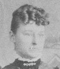
Charles Henry Bice, son of Charles and Rebecca Bice, was born in Iowa and met and married Anna Somers after the family migrated to South Dakota. Photos of Charles and Anna Bice are provided below.
Wedding photo of Charles and Anna (Somers) Bice. Photo from Charles Benson.
Charles and Anna (Somers) Bice - early photo. Photo from Charles Benson.
Charles and Anna Bice with three of their children. Photo from Charles Benson.
Anna Somers at age sixteen. Label almost certainly written by Joseph Bice. Photo from Bice album.
Apparent photo of Charles and Anna (Somers) Bice later in life. Photo from Sam Bice; identities confirmed by Charles Benson.
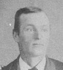
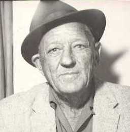
Portrait of Charles Henry Bice in his later years. Photo from Charles Benson. Photo may be reversed from negative, since the hair is combed in the other direction.
Charles Bice in His Later Years.
| Charles Henry and Anna (Somers) Bice Family Photo Near Home in Oacoma |
After their marriage, Charles and Anna Bice left Bijou Hills, where Charles' parents had settled, and lived in Oacoma, South Dakota after a brief stay in or near the Black Hills. They raised their family at their home in southwest Oacoma. Photos of the family at this home are shown below.
Back Row Right (parents): Anna and Charles Bice. Front Row (children): Robert S, Charles S, Rex L, Joseph Ornan, Whitney H, Anna Mary Bice.
Anna and Charles Bice with two of their children, probably taken earlier than the above photo. Note the badge; Charles was a law enforcement officer in Oacoma.
| Important Bice Locations in and around Oacoma and Chamberlain, South Dakota |
The map shown below2 includes Riverview Cemetery, south of Chamberlain, where Charles and Rebecca (Richmond) Bice are buried (as are their sons Frank and Donald and grandsons Robert Bice and Joe Bice, with his wife Freda). Anna (Somers) Bice and two of her two children, Charles and Rex, are buried in the Oacoma Cemetery. The family homesite of their son Charles and wife Anna (Somers) Bice (see family photos above) in southwest Oacoma is shown as are the locations of Oacoma cemetery and Riverview Cemetery near Chamberlain. Joe and Freda Bice lived for many years on a farm indicated by location "F". And the home of Charles Bice in his later years, Bice Island, is depicted on the Missouri River (see picture below the map).
Map showing several locations important to the Bice family. (U.S. Geological Survey, 1935, Chamberlain, S. Dak. Quadrangle, scale 1:62,500).
Cabin on Bice Island in the Missouri River, occupied by Charles Bice in his later years. Photo from Mary Bice, Red Lodge, Montana
Main Street of Oacoma in 1911, West View.
Main Street of Oacoma in 1911, East View.
| Children of Charles and Anna (Somers) Bice |
Charles and Anna Bice had six children; photos and a brief summary of each one is provided below
Robert ("Bob") Bice apparently had undiagnosed Aspberger Syndrome, a condition that was not recognized in the medical profession until 1944. Bob lived relatively independently, but in the care of his parents and siblings (particularly Joseph) throughout his life. Bob was a skilled fisherman in the Missouri River; he lived out his life on the Joe and Freda Bice farm west of Oacoma and is buried with them at Riverview Cemetery in Chamberlain.
Robert S Bice portrait. Date of photo unknown. Photo from Charles Benson.
Bob Bice near hand-cranked water pump on a cistern at the Joe and Freda Bice farm. Photo from Charles Benson.
Robert Bice (left) with his younger brother, Joseph, taken with horse-drawn buggy obtained by Joseph and kept on the Bice farm west of Oacoma. Photo from Charles Benson.
Charles S Bice and Harriett Cross
Charles Bice apparently lived in the Oacoma and Chamberlain area. He married Harriett Croft, and the couple had three daughters and one younger son. Unfortunately, they died within a few days of each other in the 1918 flu epidemic, leaving the children as orphans. The three girls Gertrude, Laverne, and Cleda - were adopted by William Williamson, and son Charles was adopted by John and May Benson. Charles and Harriet Bice are buried in Oacoma cemetery in the same grave plot as his mother, Anna (Somers) Bice and Charles' brother, Rex Bice. An obituary of Charles, with information on the death of Harriet appears further down on this webpage. Photos of Charles Bice and his wife and children are shown below.
Charles S Bice, Age 16. Photo from Charles Benson.
Charles S and Harriett (Cross) Bice (probable wedding picture). Photo from Charles Benson.
Daughters of Charles and Harriett Bice -- Gertrude (Trudy), Laverne and Cleda -- adopted by ___ Williams after death of Charles and Harriett in 1918. Photo from Charles Benson.
Laverne Williams, Miss Dakota, 1934. Photo from Charles Benson.
Charles Bice, 1920. Adopted by John and May (Knight) Benson after his parents' deaths in 1918. Photo from Charles Benson. Charlie Benson provided much of the information and most of the photos on this webpage.
Charles and Nila (Morgan) Benson, 1934 or 1939. Photo from Charles Benson.
Nila and Charles Benson, Valentine's Day, 1996. Photo from Charles Benson.
The will and certification of Harriet Bice, made the day she gave birth Charles and the day before she died, are shown below.
Little is known of the life of Rex Bice. He was apparently unmarried at the time of his untimely death, within nine days of his brother Charles, during the flu epidemic of 1918. Rex is buried in Oacoma cemetery in the same grave plot as his mother, Anna, and brother, Charles. His obituary appears further down on this webpage with those of his brother Charles and his wife, Harriet.
Rex Bice portrait, date unknown. Photo from Charles Benson.
Rex Bice, age 21, and Joe Bice, age 18. Photo from Charles Benson.
Joseph Ornan Bice and Freda (Sehnert) Grimshaw
Joe Bice was born in South Dakota and lived his entire life in the area around Oacoma. He served in France while in the U.S. Army during World War I. He married Freda (Sehnert) Grimshaw, who was a widow with two sons (George and Claude), and the couple had one additional son, Stanley Ellsworth Bice. Joe and Freda Bice are described in more detail in a companion webpage. Joseph's middle name was after his grandfather, Ornan Somers. Photos of Joseph and his family are shown below.
Joe and Anna Mary Bice as Children.
Joe Bice as a Young Man.
Joe Bice in World War I Army Uniform. Joe apparently served his country in France. Date of portrait photo is unknown.
Joe and Freda lived on the northwest corner of the main intersection in Oacoma, next door to an automotive garage and gas station owned and operated by Joe. Probably at the time that U.S. Highway 16 was completed on the south end of Oacoma, Joe opened a replacement gas station about two blocks west and one block south of the first garage. The couple also operated a restaurant and tourist cabins for travelers on Highway 16, the main artery across South Dakota from Sioux Falls to Rapid City. Joe and Freda moved to this new location and then moved to a former dairy farm west of Oacoma, across the Highway 16 bridge across American Crow Creek. Joe operated the gas station and garage until it was taken over by his son, Stanley Bice. Joe went into semi-retirement and operated the farm, which was severely curtailed when Fort Randall dam was built on the Missouri River and much of the farm (including Bice Island) was inundated by the reservoir.
Photos of Joe and Freda and their friends and family are shown below.
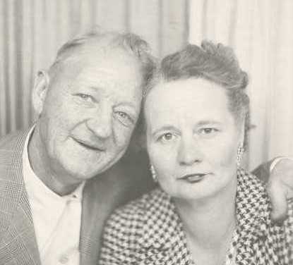
Freda and Joe at Time of Lorna Sharpe Wedding.
Freda and Joe Bice in later life. From Freda Bice album, currently owned by Fay Bice.
Joe Bice and Albert Mueller at Joe's First Garage on Main Street in Oacoma.
Second Standard Station and Garage of Joe Bice, on Highway 16 in Oacoma.
Joe and Freda and friends at Christmas dinner. Freda liked to have large holiday dinners at Thanksgiving and Christmas. As noted by husband, Joe (see biography below), "Freda was a damn good cook." From left to right: Gert Wagner, Phyllis Grimshaw, Judy Grimshaw, Fay Bice, Joe Wagner, Claude Grimshaw, Bob Bice, Freda, Joe, and George Grimshaw. Photo almost certainly taken by Stan Bice, the only family member not in the picture.
Aerial Views of Joe and Freda Bice Farm. They lived on this former dairy farm for many years after their move to that location.
Joe and Freda Bice Farm, aerial view to northeast
Same photo as above, with labels of the principal features of the farm.
Earlier view of Bice Farm; photo taken is same general direction, to the northeast. Note the less well developed trees near the house and ditch and in the shelterbelt north of the farm. American Crow Creek above the farm flows from left to right to the Missouri River. The hills above the creek form part of the Missouri River trench (along the creek) and are characterized by extensive slumping of the underlying Pierre shale in this area around Oacoma.
Joe Bice and Second Wife, Mary
Joe is on the right, and Mary is next to him. Also included in the picture are Bob Bice and Phyllis Grimshaw.
Joe Bice Jeep Rescue Operation
In the winter of 1963, Joe Bice drove is Jeep vehicle on the Missouri River ice to take a short cut to a pasture located downriver from the home place. The Jeep broke through the ice in approximately 30 feet of water, and Joe crawled through a window, barely escaping with his life. Subsequently a successful "Jeep rescue" effort was undertaken, when his son Stanley constructed a grapple hook, which was used to snag (fortuitously) the rear bumper of the submerged Jeep. Al Mueller used a video camera to record the events of the second day of the rescue operation, after the Jeep had been snagged.
Click here to see a video (using Microsoft Video Player) of the second day of the rescue.
Those identified so far in the video are Joe Bice, Stan Bice, Dee Mueller, and Paul Mueller. An interesting sidelight of the video is the view of the Missouri River Breaks in the background. Also, Fort Randall Dam had not been in existence very long, so the erosion of the banks can clearly be seen.
Thanks go to Fay Bice for relating the details of the incident to the website author, March 2010.
Descendants of Joe and Freda Bice
Stanley Ellsworth Bice, son of Joe and Freda Bice
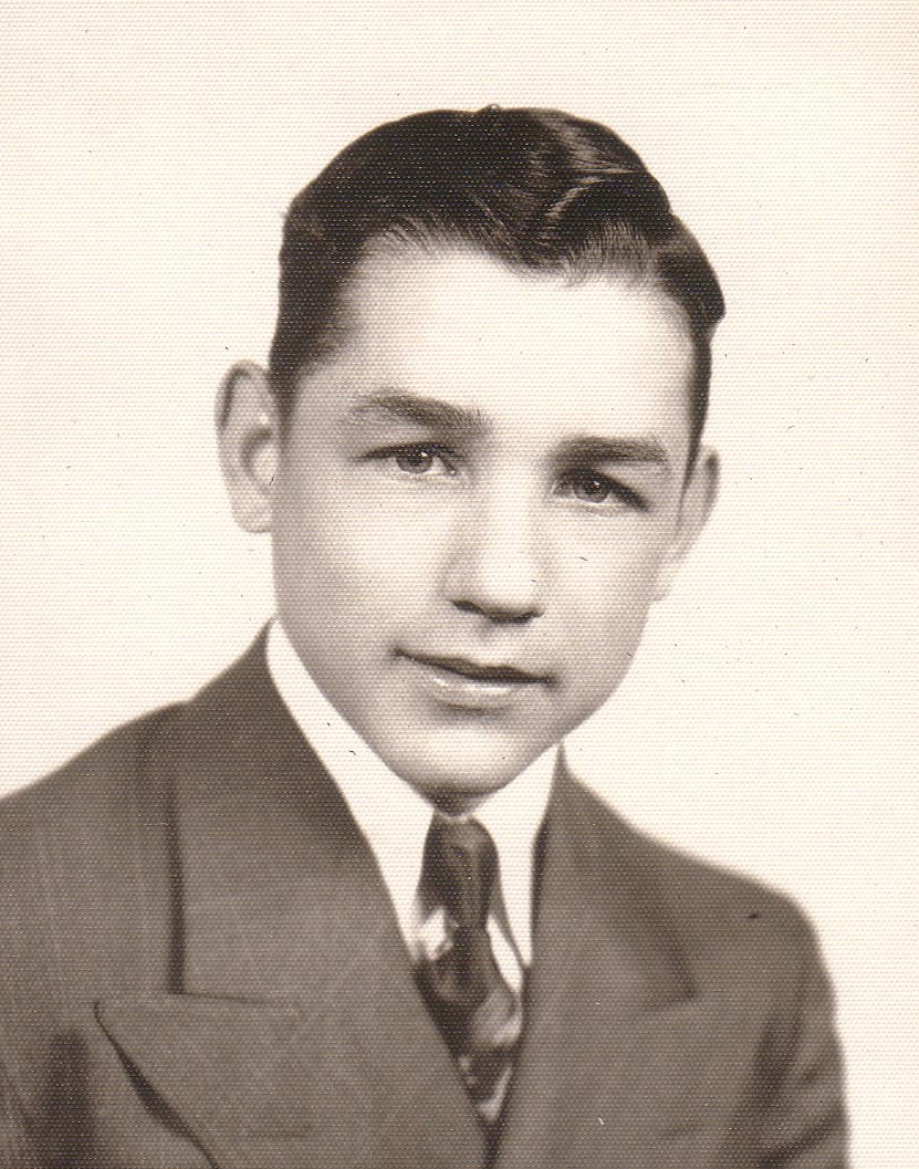
Stanley Bice in World War II U.S. Army uniform
Source: http://www.rootsweb.ancestry.com/~sdlbgs/BCWWIIpix/bcww2pix2.htm
Stanley and Fay (Sloat) Bice shortly after their marriage in 1946. From Bice Album. Thanks to Fay Bice for permission to post this photo.
Stanley Ellsworth and Fay (Sloat) Bice with children David Stanley (left) and Samuel Joseph. Photo dated December 1959. From Bice Album 1. Labeled by Freda or Joe Bice. Thanks to Fay Bice for permission to post this photo.
[Need a photo of Joe with second wife, Mary.]
Stan Bice at the graves of his parents, Freda (left) and Joe (right) at Riverview Cemetery, Chamberlain, South Dakota. Photo from Charles Benson. Date of photo unknown.
Photo Album of Trip by Joe and Freda Bice to Mexico in about 1951
(Click here to go to webpage with photo album description.)
Whitney Webster Bice. Married twice - Norma Washburn and Florence (unknown).
Whitney went by the nickname "Stub" for reasons no longer known. Photos of Stub Bice are shown below.
Stub Bice and wife (probably second wife, Norma)
Stub Bice.
Anna Mary Bice. Married twice - Burton Edward Connery and Jerry Perkins Marvin
Anna Mary apparently went by her middle name Bice. Photos of her are shown below.
Anna Mary Bice as a Girl.
Anna Mary Bice as a Young Woman.
| Family Biography by Joe Bice |
Joseph Ornan Bice apparently dictated a brief family biography which was subsequently transcribed. It is shown below. The circumstances of his preparing this biography have not yet been determined.
Yea, we used to freight between Bijou Hills and Chamberlain, carrying the mail, groceries and supplies from Chamberlain with a team and wagon. The railroad depoted at Chamberlain; father made the haul in two days. He’d go up to Chamberlain one day and usually returned on the next. I was very young at that time, so I really don’t recall the details too well; however, I remember that he used to haul to a place called “Brule City”. When I was very small, probably just after I was born, father wintered at Brule City; Mother was left in Bijou Hills.
With his hauling business, father crossed the river every now and then. He would cross at Chamberlain. There weren’t any bridges back then, not even the pontoon bridge; people used the river ferry. Now, I can’t tell you exactly when this was, but I can recall several river ferries; it was big business. John Wáit had a ferry; he was Harry Wait’s grandfather. Anyway I think they called Wait’s boat the “Captain Wait.” I believe there were two others: the “Pearl”, and the “Chamberlain”. These boats supplied the west bank of the river. They carried all types of freight, including groceries, general supplies, sacks of sugar, lumber and building materials.
These boats supplied the merchants in Oacoma. There were three grocery stores down there. Martin Brothers and Kenobbie was one store; Shepherd’s store was another. Lyman County homesteaders and ranchers supplied at Oacoma. At that time there wasn’t any other big town in Lyman County. Kennebec, Reliance, and Presho weren’t started at that time; they started when the railroad went through. That was after 1905. Besides the residents of Lyman County, many people going west to the Black Hills supplied at Oacoma.
When my parents decided to leave Bijou Hills, we supplied our wagons on the west side of the river. My Mother’s family was going out to the Hills, too. Joe Sommers, my Mother’s brother, and Sanford Sommers and his wife were going to the Hills. They decided they’d go in a covered wagon; they’d drive the cattle and the horses. I guess the whole family decided to move, I think we took two covered wagons. I was very young at that time; I can’t remember too much about the trip, but there are a few things. I’ll tell you what I remember.
We started out on the trip pretty well supplied. There was plenty of food, except meat. When we’d run out of meat, Joe Sommers would go out and rope a good, big fat calf; he called it venison. Bob, my brother, is older than me; he’d say, “that ain’t venison; I know it.” He’d say, “I know what it is; it’s a calf.”
At night we camped. There wasn’t any dams then, only creeks and rivers. We’d camp near the water when we could along the rivers and the creeks we’d fill our 16-gallon keg. I remember coming back; how hot it was in that covered wagon.
During the day we followed the wagon trail. It was just the trail from here to the Black Hills; weren’t any roads. Kind of made out as we went along; bought the things we had to have along the way.
I suppose my Dad shot quite a bit of meat. Shot chickens and grouse. There used to be a lot of them in those days. Dad used to shoot those grouse.
We didn’t stay in the Hills too long. The trip back was pretty much the same. Joe Sommers, Hav Sommers, my Dad, my brothers, Rex, Bob, Charly and I came back. It took thirty-two or thirty-three days, I think, to make the trip.
When we got back to Oacoma, my Dad went into the gravel hauling and dray business. He freighted between Oacoma and Chamberlain; made two trips a day: one in the forenoon and one in the afternoon. He crossed on the ferryboat, except in the wintertime. When the river froze up, he crossed on the ice. There wasn’t any special skis for the wagon, except when it snowed he’d use a sleigh,
Then, in 1905, the railroad crossed the river. The town knew it was coming and had been planning for it. They had a big celebration. I was there when the first train stopped; I was eleven years old. It was a passenger train, and it was just loaded, with people. There were people on there from Sioux City and Omaha. It stopped right where the cement blockhouse was.
Most of the prominent citizens of the town were there to meet that first train: Frank A. Smith, the banker; Albert and William Williamson, John Bartine, the lawyer. Well, there were a lot of other people there too, but I can’t remember them all. But, Oacoma was a busy place in those days
Besides three grocery stores, there was three livery barns, three hotels and Miss Artz’s Millinery Shop. She had ice cream and stuff in there. I’d watch the place for her when Judge Bartine took her out grouse hunting. Used to be a lot of grouse in this country. There was a tombstone outfit, a post office and quite a few law offices. It was the county seat of Lyman County. At first there wasn’t a real fancy courthouse just an old wood building. Finally, they tore that wood courthouse down; built the hall that they now got down there. That’s where the County seat was til 1922.
In ‘22 there was a big fight over the county seat. Oh, yea; a pretty stiff fight, too. Beat us by eleven votes; they came down here … a bunch from Kennebec … to move the court records. The Judge wouldn’t let them move them until they recounted the ballots. They kept the courthouse here for quite a while afterwards; the citizens of the western part of the country were rattling at the courthouse doors. Finally the people of Oacoma gave in. They moved the county seat to Kennebec. A lot of people believed they padded the votes; voted schoolteachers and Indians and everything else … never could prove it, though.
You ask me what kind of people they were, same as anybody else.
Well, Mr. Mueller really fought the removal of the county seat, took it all the way to the South Dakota Supreme Court… lost anyway.
Myself and Mr. Mueller were very good friends. The Mueller store had been owned by Charlie Bice; had it for two or three years. That was a strange deal. Charlie had been running it about a year or so when I went into the service. When I left, he told me that he had it under control. He didn’t have it all paid for, but he had paid quite a lot on it. In the back part of the store, he had canned goods. He had a bar right back of the store where that garage is now. But, Williamson and Harry Smith claimed he hadn’t paid anything on it. Beman Strong put 'em up to it. Strong built the building somewhere’s around 1903, Dad dug the basement, used a team and scraper. Anyways, when Charly died of the flu, Beman Strong took the store over again. Albert bought the store from Strong, I think around 1919.
Well, Oacoma was a cowboy town, even in 1919. In the real early days when I was just a kid, cowboys came to town, to gamble and drink. There were three saloons. Two I remember particularly: “The First Chance” and “The Last Chance”. John Havvey ran “The Last Chance”. It was on the west end of town. Bill Place ran “The First Chance”. It was just on south side of main street across from the Post Office … about where the old store was. Place had a gamblin’ joint on one side. I was too small to go into “The First Chance”; but my uncle,’ Hav Sommers, used to take me in there. Place would say, “Get that kid out of here!” “Leave him alone; he’s with me”, Hav would say.
Uncle Hav left here for Canada under strange circumstances. He’d bought some horses from a guy in jail. The horses were stolen. We tried to reach Uncle Hav; even tried to put the Canadian Mounted Police to tracking him down. Must have taken assumed name. Never heard from him again.
In those days there were a lot of shady deals. All the cowboys carried revolvers. They carried guns for protection; personal protection. I recall one time when they rode their horses into Frank Martin’s store. I think Olaf Nelson did damage … rode in and shot the place up. Olaf moved to Sioux City; he married a woman that owned a bank down there. Left town in good shape. Bank finally went broke. Frank Martin had $15,000 in that bank. Nelson showed up one night at Martins with $15,000 in his pocket. Paid Martin his money.
One of the worst thieves was a fella by the name of Jack Sully, a foreman on the Phillips ranch. He had a medium build, fairly heavy set. Nobody tangled with him. I remember when they shot shot old Jack Sully. Sully stole a bunch of cattle from Ham and ran them across to Nebraska. They sent a posse after him; claim Harry Ham shot him. Way I heard it, they’d caught up. with Sully; had him caught. But, they told him to try to get away. He started down the draw; Ham drew and shot him in the back. Sully knew too much.
Later, there was a worse kind of crook. That was in the ‘30’s. Was really tough in those days There was grasshoppers, no rain, no crops. Attorneys like Sharpe and Miller picked up a lot of land. That’s how they made their money. Took people unscrupulously. I rented the old garage from Sharpe for eleven years, paid him every month. One day J.W. Jackson, the county judge, called me. He said, “Joe, the county’s going to sell that garage; it don’t belong to Sharpe.” He said, “Come in and see me tomorrow before the tax sale.” Judge Jackson was a damn good friend. We scrapped together $1,100 00, and I bought the place. Sharpe never did own it.
Another deal was that twenty-eight acre piece down by the Oacoma school. That land belonged to A.B. and Kate. Dugan put up the money to have it sold, before the sale the county sold it to M.Q. Then about 1952, Ore Forell, the county auditor, sent me notice of mistake. He said that Sharpe owned that land. He done that all over, stole half of what he owned. Think he slipped Forrell something under the table … Crooked!
Just before I left for the service, Dad and I bought Hicky’s Island. It was a large island … about 220 acres. We bought it from Hanson. It was an island built up from the sandbar; just a matter of the channel switching. After I came home from W.W. I, I was on the island with Dad for quite a while; then it was called Bice Island. Then, I started that garage.
That was about 1919. I was the Oacoma Standard dealer. Regular gas sold for about l8¢ per gallon; ethal sold for a little more. My profit margin was about 2¢ per gallon on the regular and about 3¢ per gallon on the ethal. They used to deliver gas in tank wagons brought across on the ferry. Think it cost $1.00 to ferry across; later they brought the wagons across the pontoon bridge.
About that time, I married Freida Sehnert. She’d been married before to Claude Grimshaw who died during the flu epidemic. Freida ran a cafe across from the old store. After I married her, it became the “Bice Cafe.” Pie and Coffee was 10¢. A whole pie 35¢, a meal ticket – $l.00 a day. We operated the cafe until they moved the courthouse to Kennebec. That was around 1926. Freida was a damn good cook.
Now, you ask me if I’ve seen a lot, I’ve seen a team and buggy get stuck right in the middle of main street, Christ, I’ll say I’ve seen a lot…
| Family Bible Records of Charles H and Anna (Somers) Bice |
The image and transcription of the family Bible of Charles and Anna Bice are provided below. The dates have been modified to conform to conventional format. Anna apparently made the initial entries. Many of the subsequent additions were probably by Joe Bice.
Main Entries: Name, Place of Birth, Date of Birth, Date of Marriage, Date of Death (Handwriting appears to be Sara Bice, based on diary entry elsewhere)
Charles H. Bice, Hancock Co, Iowa, 4 Apr 1859, 3 Nov 1883, 23 Sep 1946
Sara A. Bice, New Brunswick, Canada, 16 May 1866, 3 Nov 1883, 15 Nov 1942
Robert S. Bice, Chamberlain, Brule Co, SD (Bijou Hills), 18 Mar 1885, never married
Charlie S. Bice, Chamberlain, Brule Co, SD (Ola), 23 Aug 1898, 26 Oct 1910, 5 Nov 1918
Rex L. Bice, Chamberlain, Brule Co, SD (Brule City), 12 Feb 1892?, never married, 14 Nov 1918
Joseph O. Bice, Chamberlain, Brule Co, SD (Dry Island), 30 Oct 1894?, 24 Oct 1921, (blank)
Whitney H. Bice, Oacoma, SD, 11 Apr 1902?, 12 May 1923, (blank)
Anna M. Bice, Oacoma, Lyman Co, SD, 3 Sep 1906, (blank), (blank)
Stanley E. Bice, Oacoma, SD, 10 Oct 1922, 15 Jul 1946, (blank), (blank)
Freda E (Sehnert) Bice, Saxton, Germany, 26? Jun 1892, 29 Oct 1921, 5 Jun 1964
Joseph O Bice, Chamberlain, SD, 1894, 29 Oct 1921, (blank) [double entry]
C. L. S. Bice Jr., Chanberlain, Brule Co, SD, 23 Aug 1888, 26 Oct 1910, 5 Nov 1918 [double entry]
Harriet Cross Bice, Kimball, SD, 8 Sep 1880?, 26 Oct 1910, 10 Nov 1918
Baby Bice, Oacoma, 24 Feb 1912, (blank), 5 Mar 1912
Mary L. Bice, Oacoma, 25 Feb 1913, 1935, 27 Jul 1982
Cleola C? Bice, Oacoma, 16 Dec 1914, 3 Jan 1942, 1 Dec 1990, Rapid City
Gertrude Lucile B., Oacoma, 24 Dec 1916, 1939, (blank)
Charles Herald S? Bice, Oacoma, Lyman Co, 9 Nov 1918, 1 Sep 1939, (blank)
Above Main Entries
Florence Elizabeth Whitney, Baker, Bice (Sixth), Born 8 Nov 1910, 23 May 1969 [upper right corner]
Chas H. Bice and Anna Somers, Married at Chamberlain Nov 3 1883, witness John K Somers, Seslie Skurg?, OP? Morrow, Justice of Peace
Below Main Entries
Robert Bice Born at Bkjou Hills
Charley at Ola
Rex at Brule City
Joe at Dry Islan
Whit at Oacoma
Left Margin
Whitney Bice Second, Married 25 Apr 1925
Whitney W. Bice born 11 Apr 1901
Anna Mary Bice born 23 Sep 1906
DeWayne Bice born 29 May 1923
Charls Llewelen born 9 Jan 1926
Mary Alice Meager Bice born 21 Oct 1924, 119(24)?
Joseph Ornan Bice, Born 30 Oct 1894
Stanley Ellsworth Bice, born 10 Oct 1922
Right Margin
Harriet 28 yrs 2 mo 2 days
Charley 30 yrs 2 mo 12 days
Geo Grimshaw born Presho 27 Mar 1918 - 1939 married 11 Feb 1939 - died 28 Mar 1971
Stanley Bice born Oacoma 10 Oct 1922 - 1946 married 15 July 1946
Chas H. .. Benson married Nila Morgan 1 Sep ?
Stan married 15? - in 76
| Obituaries of Charles and Harriet Bice and Rex Bice |
Charles died November 5th, his wife Harriet on November 9th, and Rex on November 14, 1918 during the flu epidemic. Their obituaries, and that of Rex Bice, are shown below.
LYMAN COUNTY ARGUS-LEADER Oacoma. Nov 7, 1918 issue:
BUSINESS MAN CALLED
Monday night Charles S. Bice, one of Oacoma’s leading business men died of influenza. Mr. Bice will be greatly missed in our town as he was a hustler and a very congenial, obliging, always ready with a courteous word to attend the public’s wants. The burial will be made Friday morning at 10:00 o’clock. Short service at the grave but no other services. A further obituary will appear next week. At this writing Mrs. Bice is very ill of the disease.
LYMAN COUNTY ARGUS-LEADER Oacoma Nov 14, 1918 issue:
SADNESS OVER ALL OACOMA
Oacoma has been called upon to pass through one of the saddest events come to a small place. On Tuesday morning November 5th, Charles S. Bice, one of our leading business men, passed from this life. On Saturday morning, November 9th, a son was born and on Sunday morning, the 10th, the wife followed the husband to that long home, and four sweet little children were thus bereft of the care of loving parents. The children’s ages range from nearly six years to the baby born last Saturday morning. All that kind neighbors and friends could do has been and is still being done for the stricken ones. The little ones are to be taken into homes here by adoption and tenderly cared for.
Charles S. Bice was thirty one years of’ age and has spent the larger part of his life in Oacoma, receiving his education in the public school of this town.
Eight years ago in October, he was united in marriage to Harriet R Cross of White Lake and they established their home here. Seven years ago he entered the employ of T. B. Strong in his general merchandise store and became a proficient business man. A year ago in July he purchased from Mr. Strong the stock and building, which is one of the best in Oacoma. Charley was making a great success of his undertaking. He was a hustler, always courteous to his trade. His untiring energy was perhaps his undoing for after being stricken with influenza, he remained too long at his labor and pneumonia developed. His wife, Harriet R. Cross was a native of’ White Lake. She entered the employ of the Argus-Leader nine years ago and it was thus that the friendship which developed into riper relationship was formed it was- a true love match and these two lives entwined about each other and the children born to them was truly ideal. The esteem in which they were held by our people was shown by our people by the beautiful floral offering sent in the hour of’ bereavement.
Funeral services were held for Charles Bice Friday morning in Graceland cemetery at ten o’clock. Appropriate music was sung by a mixed choir and a few remarks were made by Judge Williamson. Services at the grave of Mrs. Bice were held at ten o’clock Monday morning and the same choir rendered appropriate selections Rev. Hoyer of the Methodist church of Chamberlain spoke from the text “When thee father and mother forsake thee the Lord will take thee up”. He used this text in connection with the little ones left orphaned. He said that he felt assured that the way would open for the care of the parentless children. Death is always sad when it takes those of younger years but this instance seems doubly so. Besides the children Mrs. Bice is survived by a father and mother and two brothers both of whom are in the U.S. Navy. Mrs. W. H. Gross, the mother of Hot Springs; was present during the sickness and burial of her daughter and son-in-law. Mr. Bice is survived by his children, parents, Mr. and Mrs. Charles H Bice of Oacoma and four brothers and a sister. One brother, Joseph, is in France with our troops.
LYMAN COUNTY ARGUS—LEADER Oacoma, Nov 21, 1918:
OBITUARY
Rex Leon Bice was born in Brule County, S. D. Feb 12, 1891 and died at the Chamberlain Sanitarium Thursday Nov. 14th at 7:20 A.M. of influenza,
Rex was the third son of Mr. and Mrs. Charles H Bice and moved to Oacoma with his parents about twenty years ago. He received his education in the Oacoma schools and was a good scholar and a favorite with his associates. Rex was not of very strong physique and when called for examination for army service, was placed in the limited service class. He was called for limited service in August and went gladly to be of service to his country but on further examination at camp was unable to pace the test and was honorably discharged. It is a sad community that united in sympathy for Mr. and Mrs. C. Ii. Bice and family in the triple bereavement that has come to them in the past week. To bury three is indeed hard to bear. Funeral services were held at the grave in Graceland cemetery Friday morning at ten o’clock. Rev. Young of Chamberlain preached a short sermon to the friends assembled there to pay their last tribute of friendship to the deceased Two beautiful selections were sung by the choir. Loving hands assited in lowering all that was mortal of Rex Bice to their last resting place.
| Final Resting Places of Charles and Rebecca Bice and Their Descendants |
Charles and Rebecca Bice lived in Bijou Hills, where they settled after arriving in South Dakota. They are buried in Riverview Cemetery near Chamberlain, South Dakota.
Bice Family Plot in Northwest corner of Riverview cemetery. Graves of four individuals - Charles, Rebecca, Stanley D, and Frank L Bice. Eastward view.
Fay Bice reported in October 2008 that her husband, Stanley, used to visit two bachelor Bice brothers on a farm in Brule County. It is likely that they were Frank and Stanley Bice.
Anna (Somers) Bice and members of her family are buried in Oacoma Cemetery. Charles died while visiting his daughter, Anna Mary, in Red Lodge, MT and is buried there. No photo is currently available. The Oacoma cemetery apparently has the name "Graceland Cemetery". Photos are shown below.
Northeastward view of family plot in Oacoma (Graceland) cemetery. Charles and Harriet Bice in the foreground. Anna (Somers) Bice to the right and behind. Rex Bice to the left and behind. Donald L Bice to the left of the tree. Photo taken June 2007.
Closeup of the headstone of Anna (Somers) Bice. Photo taken June 2007.
Closeup of the headstone of Rex Leon Bice. Photo taken June 2007.
Ronald Allen Bice. Ronald was the son of Whitney and Norma (Washburn) Bice. Photo taken June 2007.
Northwestward view of cemetery. Bice plot under two trees to the left. Charles and Harriet Bice gravestone to left of left-most tree. Photo taken June 2007.
Joseph Ornan Bice and his wife, Freda (Sehnert) Grimshaw Bice are buried in Riverview Cemetery, Chamberlain, SD, as is Joe's older brother and Robert Bice. Grave photos are shown below.
Graves of Freda, Joe, and Robert are shown from left to right. They are located on the east side of the cemetery. Southeastward view. Photos taken June 2007.
| Bice Family History from Todd Houghton |
Todd has generously contributed the following information on the Bice family.
1. WILLIAM2 BICE (WILLIAM1) was born July 02, 17901, and died May 05, 1871 in Mercer Co., Ohio1. He married MARY INGLING October 28, 18151. She was born August 05, 17971, and died June 10, 1877 in NJ or Pennsylvania1.
More About MARY INGLING:
Burial: Neptune, Mercer Co., Ohio
Children of WILLIAM BICE and MARY INGLING are:
2. i. MARY ANN3 BICE, b. January 08, 1837, Salem, Columbiana Co., Ohio; d. September 08, 1884.
ii. SARA ANN BICE, b. August 11, 1816, Salem, Coumbiana Co, Ohio1; d. March 09, 1834, Columbiana Co., Ohio2; m. SAMUEL FRAZIER.
3. iii. SAMUEL BICE, b. January 19, 1818, Salem, Coumbiana Co, Ohio; d. 1889, Spencerville, Allen Co, Ohio.
4. iv. ZADOCK BICE, b. March 09, 1820, Salem, Coumbiana Co, Ohio; d. July 20, 1861, Allen Co, Ohio.
5. v. JEREMIAH BICE, b. July 15, 1822; d. December 24, 1900.
6. vi. WILLIAM BICE, b. March 28, 1824; d. February 07, 1901.
7. vii. CHARLES BICE, b. June 18, 1826, Salem, Coumbiana Co, Ohio; d. June 26, 1908, Chamberlain Brute Co., South Dakota.
8. viii. CLAYTEN BICE, b. February 16, 1828, Salem, Columbiana Co., Ohio; d. April 09, 1854, Neptune, Mercer Co., Ohio.
ix. CHARLOTTE BICE, b. April 06, 1830, Neptune, Mercer Co, Ohio3; d. April 29, 18523; m. MILES RIDER, September 25, 18513.
x. SUSEN B BICE, b. April 27, 18323; d. August 29, 1852, Neptune, Mercer Co, Ohio3.
9. xi. GRANVILLE BENTLY BICE, b. September 04, 1834, Salem, Columbiana Co., Ohio; d. January 19, 1913, Payne, Ohio.
xii. THOMAS CLARK BICE, b. July 16, 1838, Portage Co., Ohio3; d. February 04, 1896, Darke Co., Ohio; m. VIOLA STEWART, November 14, 1871; b. 1842, Enon Valley, Pa..
xiii. MARY ANN BICE, b. April 06, 1830; d. Abt. 1830.
----------------------------
7. CHARLES3 BICE (WILLIAM2, WILLIAM1) was born June 18, 1826 in Salem, Coumbiana Co, Ohio34, and died June 26, 1908 in Chamberlain Brute Co., South Dakota34. He married REBECA ADELLA RICKMOND August 10, 1853 in Mercer Co., Ohio34. She was born August 17, 1836, and died March 28, 1917 in Chamberlain Brute Co., South Dakota.
More About CHARLES BICE:
Burial: Riverveiw Cemetery, Brule Co.,Chamberlain, South Dakota35
More About REBECA ADELLA RICKMOND:
Burial: Riverveiw Cemetery, Brule Co.,Chamberlain, South Dakota35
Children of CHARLES BICE and REBECA RICKMOND are:
i. ALICE4 BICE.
ii. CYNTHIA SAMANTHA BICE, m. REX BERNER.
23. iii. MARY ELLEN BICE, b. June 18, 1856, Clear Lake, IA; d. June 17, 1924, Persia, IA.
24. iv. CHARLES HENRY BICE, b. April 04, 1856; d. September 23, 1946, Red Lodge, Mt..
v. HATTIE ADELLA BICE, b. July 07, 1861, Ellington, Iowa; d. January 15, 1905, Chamberland Brute Co., South Dakota; m. FRED GOFF.
vi. FRANK ESWORTH BICE, b. March 26, 1865, Ellington, Iowa; d. January 05, 1941, Chamberlain Brute Co., South Dakota.
More About FRANK ESWORTH BICE:
Burial: Riverveiw Cemetery, Brule Co., Chamberlain, South Dakota36
vii. STANLEY DARWIN BICE, b. August 31, 1872, Ellington, Iowa; d. October 24, 1946, Chamberlain Brute Co., South Dakota.
More About STANLEY DARWIN BICE:
Burial: Riverveiw Cemetery, Brule Co., South Dakota
----------------------------
24. CHARLES HENRY4 BICE (CHARLES3, WILLIAM2, WILLIAM1) was born April 04, 1856, and died September 23, 1946 in Red Lodge, Mt.. He married SARAH ANN SOMERS, daughter of ORNAN SOMERS and BATHSHEBA CROFT. She was born 1866, and died 1942.
Children of CHARLES BICE and SARAH SOMERS are:
i. ROBERT5 BICE, b. March 18, 188560; d. March 31, 196960.
More About ROBERT BICE:
Military service: WW1 vet60
ii. CHARLES BICE, b. 188860; d. November 05, 191860.
More About CHARLES BICE:
Cause of Death (Facts Pg): died of influenza I think60
iii. REX LEON BICE, b. February 12, 1892, Chamberlain, SD61; d. November 05, 191862.
More About REX LEON BICE:
Burial: Graceland Cementary, Oacoma, SD62
Military service: WW1 vet63
42. iv. JOSEPH ORMEN BICE, b. October 30, 1895, Dry Island, SD; d. January 01, 1978.
v. WHITNEY WEBSTER BICE, b. April 11, 190064; d. December 198964; m. FLORENCE.
More About WHITNEY WEBSTER BICE:
Residence: Lived in Franklin, Neb. in 197364
Social Security Number: 503-07-395565
vi. MARY BICE, b. September 03, 1906, on island in the Missouri River, Lyman Co., SD66; d. July 17, 2000, Red Lodge, Montana66; m. (1) BERT CONNERY; m. (2) JERRY P. MARVIN, June 20, 193266; d. 197266.
More About MARY BICE:
Religion: Chuch: Red Lodge Community Church
Residence: "Last time I was in touch with her was in 1973, she then was in Red Lodge, MT."67
----------------------------
42. JOSEPH ORMEN5 BICE (CHARLES HENRY4, CHARLES3, WILLIAM2, WILLIAM1) was born October 30, 1895 in Dry Island, SD98, and died January 01, 197899. He married (1) FREDA E. (SCHNERT) GRIMSHAW, daughter of RICHARD SCHNERT and ANNA. She was born January 16, 1892 in Germany99, and died January 05, 1964100. He married (2) MARY.
More About JOSEPH ORMEN BICE:
Burial: Riverview Cemetary, Chamberlain, SD
Military service: WW1 vet 6/24/1918-5/28/1919101
Residence: "(I) believe he lived in Lyman Co., SD"101
Social Security Number: 503-12-1661
Child of JOSEPH BICE and FREDA GRIMSHAW is:
i. STANLEY E.6 BICE, b. October 10, 1922101; d. October 14, 1993101; m. FAY FLOAT, July 1945101.
More About STANLEY E. BICE:
Military service: WW2 vet 1/18/1943-11/25/1945101
Residence: 57702 Rapid City, Pennington ,SD102
Social Security Number: 503-16-8115102
| Somers Family Information from Shirley Lillo |
Shirley Lillo has generously provided a great deal of information on the ancestors of Anna Somers. It is provided below.
Hello Tom,
My "History File" is all in my many notebooks. But I can put something together for Sam's sons.
1 Matthias Somers. First known of our family to come from Europe (perhaps Germany) to Pennsylvania, then went North to New Brunswick to the area which became the city of Moncton, the area at that time was still part of Nova Scotia. Matthias & Magdalena & the other settlers landed at Hall's Creek June 3, 1766.
m. St. Michael's Zion Church Philadelphia Oct 23, 1749 Mariah Christina Null
Children with Mariah:
Anna Catharina bapt. Nov 8, 1750 in Philadelphia---m. 1767 Eliphalet Chappell
Eva Magdalena bapt. Feb 6, 1753 in Philadelphia--may have died an infant
Sarah b. ca. PA 1755--m. Jan 1, 1771 Benjamin Allen
Anna Christina b. ca. PA 1757--some say she m. George Dobson Mar 27, 1780 and some say she m. Henry Jones ca. 1778. She is a much sought after lady!!
m. Aug 15, 1758 Magdalena Aldman of Frankford, PA--a widow with no apparent children.
Children with Magdalena:
Elizabeth b. PA Feb 13, 1759--difficult to trace, husband unknown
Rachel b. Jan 13, 1764 b. probably in Barren Hill, PA--m. Jun 25, 1780 Frederick Steeves
Andrew b. ca. 1765 probably Barren Hill, PA--m. but to whom is not certain
Matthias died about 1768 in Moncton. Widow Magdalena was married to the widower Jacob Ricker by the census of 1770.
Dates here I took from the new book by Dr. Rainer L. Hempel, "New Voices on the Shores." He & his crew of researcher's work was recommended by Steeves Family, Inc. in Hillsborough, NB, Canada. It did leave some of us who purchased the book a little more confused in some areas, but I do think it a marvelous book.
There is much to be found on the internet about these Pennsylvania settlers. The copy of the Articles of Agreement for going to Nova Scotia can be found on the Lutz Mountain Heritage Foundation website--click on to the Steeves name & it will come up--Matthias Somer was the first signer. Nan's "Jones" Genealogy Page is a good one, & of course, there is Steeves Family Descendants Page--I use GOOGLE search engine & it brings up just about anything I can be searching for.
I have to go make some lunch for the master so I will return with generation
Generation 2 of Somers (Also spelled Somer, Sommer, Sommers)
2 Andrew Somers. Andrew's last will & testament filed Jan 24, 1839 & was proved July 17, 1840. Some Somers researchers list Andrew's wife as Elizabeth Smith but no documentation could be found. A wife "Amy" has been mentioned as his wife in a "goods purchase" she made. Some also state she was Elizabeth Beck. Some call her Unknown! Andrew the only male heir of Matthias to carry on the Somers name but Andrew was more fortunate, he had two sons!
Children with Hempel birthdates: Births I collected:
Deborah b. ca. 1788 m. Nov 19, 1805 Charles Jones 1787
Rachel b. 1790 m. Mar 14, 1815 Timothy Horsman 1791
Elizabeth b. 1790/91 m. ca. 1821 Charles Trites 1789
Mathias b. 1791/92 m. ca. 1815 Elizabeth Jones 1792
Sarah b. ca. 1796 m. Jan 6, 1820 James Anderson May 15, 1794
Martin b. ca. 1793 m. Feb 27, 1817 Sarah "Sally" Trites 1798
Lucy b. ca. 1798 m. nothing known about her 1796
Susanna b. 1800 m. Mar 29, 1821 Anthony Simpson 1801
Catherine b. 1804 m. Sept 4, 1828 1803
Rebecca b. 1810 m. Oct 8, 1829 Jacob Trites 1811
I did find a Naturalization Record for son Martin in South Dakota dated 11/02/1885. He was 85 years of age; if that was correct he would have been born circa 1798. He was said to be in SD living with his son Shepard in 1891. I do not know. He did come to SD to "visit" his family from New Brunswick, I'd heard------but I never did hear if he returned to Canada or if he died in SD; I have never found a grave for him there. The Somers family is full of Mysteries!
Generation 3 coming up
Generation 3
Martin Somers b. 1798 Lived to be over 100 years old, I heard.
m. Feb 17, 1827 Sarah Trites
Children:
Shepard b. 1821 m. Elizabeth Steeves migrated to Dakota Territory
?Jane b. Jun 18, 1822 d. Jan 1913 m. Dickie Steeves
Lafayette b. Oct 10, 1826 m. Elizabeth Chapman migrated to Dakota Territory
Theodore b. 1828 m. Elizabeth _______
Marvin H. "Jim" b. 1835 d. Feb 13, 1880 migrated to Dakota Territory; died in gunfight with nephew Bradley who was a son of Lafayette & Elizabeth
Ornan b. 1836-d. SD Jan 25, 1879 m. Bathsheba Croft b. 22 Jul 1837-d. Nov 9, 1917 migrated to Dakota Territory
Sarah. Have found out nothing about her
Theresa m. Jacob Jones
Marvin & Bradley were buried on the land where upon they died. That land is now buried beneath the waters of the Missouri River. Marvin may have been the first Somers to arrive in Dakota Territory from NB--he was there according to his age & history when he was in his early twenties......wonder if he traveled alone?
Ornan may have come to Dakota before Bathsheba. Bathsheba left Nova Scotia, birth year listed as 1843, came through the port of East Port, immigration year 1879. He must have died as soon as she arrived. (The dates above for the family members are not my own.) Widow Bathsheba m. Charles Henry Lewis. And you know Anna Sarah Somers, dau. of Ornan & Bathsheba, married Charles Henry Bice.
I branch off here with Lafayette through his son Clifford Martin Somers, who was the father of my Dad, Treon Bradley Somers.
Son Shepard above, with his wife Elizabeth Steeves, evidently had 16 children. Some of the children remained in NB & others came to Dakota. Not long ago, I found another family for Shepard (Sheppard Royal Somers)---before he married Elizabeth he had 5 children by Margaret Wilbur, they lived on neighboring farms in NB and there was no record of a marriage for them. A couple of those children took the Somers name after they grew up and the others kept their mother's Wilbur name.
A branch of the Wilbur family has thoroughly researched this so I would never again question it--I did & they set me straight! You can find this family & it's history by searching for Margaret Wilbur in the WorldConnect Project, if you are interested. It just kind of made me wonder how come they never had a Shotgun Wedding---Margaret's father is said to have been a Baptist Preacher!
If you want something different here, let me know & I will see if I can help---------------
We are getting rain right now & is supposed to turn to snow---Oh, Yuk!
Shirley
The following summary ancestor chart has been prepared from the above Somers family information from Shirley Lillo.
1 Matthias Somers (? - 1768, Moncton, Nova Scotia) & Mariah Christina Null. Married 23 Oct 1749, Philadelphia, PA.
|---2 Anna Catharina Somers (bpt 8 Nov 1750, Philadelphia - ?) & Eliphalet Chappell
|---2 Eva Magdalena Somers (bpt 6 Feb 1753, Philadelphia - ?)
|---2 Sarah Somers (PA, ca 1755 - ?) & Benjamin Allen. Married 1 Jan 1771
|---2 Anna Christina Somers (PA, ca 1757 - ?) & George Dobson (m. 27 Mar 1780) or Henry Jones (m ca 1778)
1 Matthias Somers (? - 1768, Moncton, Nova Scotia) & Magdalena Aldman. Married 15 Aug 1758.
|---2 Elizabeth Somers (PA, ca 13 Feb 1759 - ?)
|---2 Rachel Somers (13 Jan 1765, Barren Hill, PA? - ?) & Frederick Steeves. Married 25 Jun 1780.
|---2 Andrew Somers (ca 1765, Barren Hill, PA? - ?) & ?
|---|---3 Deborah Somers (ca 1788 - ?) & Charles Jones. Married 19 Nov 1805.
|---|---3 Rachel Somers (1790 - ?) & Timothy Horsman. Married 14 Mar 1815.
|---|---3 Elizabeth Somers (1790/91 - ?) & Charles Trites. Married ca. 1821
|---|---3 Mathias Somers (1791/92 - ?) & Elizabeth Jones. Married ca. 1815.
|---|---3 Sarah Somers (ca 1796 - ?) & James Anderson. Married 5 Jan 1820.
|---|---3 Martin Somers (ca 1793 or 1798 - ?) & Sarah ("Sally") Trites. Married 27 Feb 1817.
|---|---|---4 Shepard Somers (1821 - ?) & Elizabeth Streeves
|---|---|---4 Jane? Somers (18 Jun 1822 - Jan 1913. Married Kickie Steeves
|---|---|---4 Lafayette Somers (10 Oct 1826 - ?) & Elizabeth Chapman.
|---|---|---|--- 4 Bradley Somers
|---|---|---4 Theodore Somers (1828 - ?) & Elizabeth
|---|---|---4 Marvin H ("Jim") Somers (1835 - 13 Feb 1880)
|---|---|---4 Ornan Somers (1836 - 25 Jan 1879, SD) & Bathsheba Croft (22 Jul 1837 - 9 Nov 1917).
|---|---|---|---5 Anna Sarah Somers (16 May 1866 - 15 Nov 1942) & Charles Henry Bice (4 Apr 1859 - 23 Sep 1946)
|---|---|---4 Sarah Somers
|---|---|---4 Theresa Somers & Jacob Jones
|---|---3 Lucy Somers (ca 1798 - ?)
|---|---3 Susanna Somers (1800 - ?) & Anthony Simpson. Married 29 Mar 1821.
|---|---3 Catherine Somers (1804 - ?) & unknown. Married 4 Sept 1828
|---|---3 Rebecca Somers (1810 - ?) & Jacob Trites. Married 8 Oct 1829.
| Origin of the Bice Surname (and Coat of Arms & Family Crest) |
"Bice" apparently originated in England, Germany, Italy, Ireland, Switzerland and The Netherlands. Two websites that sell coats of arms and family crests describe the English origins of "Bice" as follows.
Coat of Arms / Family Crests Store
This surname BICE was of the baptismal group of surnames meaning 'the son of Biset' an ancient personal name. The name appears originally to be of Teutonic origin, and was brought into England in the wake of the Norman Invasion of 1066. Early records mention BISSE (without surname) who was documented in County Gloucester in the year 1199. Biss Dapifer of the County Gloucester was recorded during the reign of Edward I (1272-1307). The name is also spelt BISET and BISSETT. Edward Biset of Yorkshire was listed in the Yorkshire Poll Tax of 1379, and William Biset appears on the same document. Maunsel Bisset County Worcester, 1440. Samuel Biset was listed in the Wills at Chester in 1596, and William Bissett of Glamorgan, registered at Oxford University in the year 1602. William Bisset married Jane Mills at St. George's, Hanover Square, London in 1764. The rise of surnames, according to the accepted theory, was due to the Norman Conquest of 1066 when Old English personal-names were rapidly superseded by the new christian names introduced by the Normans. Of these, only a few were really popular and in the 12th century this scarcity of christian names led to the increasing use of surnames to distinguish the numerous individuals of the same name. Some Normans had hereditary surnames before they came to England, but there is evidence that surnames would have developed in England even had there been no Norman Conquest. The development of the feudal system made it essential that the king should know exactly what service each person owed. Payments to and by the exchequer required that debtors and creditors should be particularized, and it became official that each individual acquired exact identification. At first the coat of arms was a practical matter which served a function on the battlefield and in tournaments. With his helmet covering his face, and armour encasing the knight from head to foot, the only means of identification for his followers, was the insignia painted on his shield, and embroidered on his surcoat, the draped and flowing garment worn over the armour.
House of Names
Where did the English Bice family come from? What is the English coat of arms/family crest? When did the Bice family first arrive in the United States? Where did the various branches of the family go? What is the history of the family name?
The family name Bice dates back to the beginnings of the Norman culture in Britain - the Norman Conquest of 1066. Originally, Bice was a name given to a person with a dark complexion or person who dressed in dark clothing. The name stems from the Old English root bis, which means dingy or murky.
Spelling variations in names were a common occurrence in the eras before English spelling was standardized a few hundred years ago. In the Middle Ages, even the literate regularly changed the spellings of their names as the English language incorporated elements of French, Latin, and other European languages. Many variations of the name Bice have been found, including Biss, Bisse and others.
First found in Surrey, where they had been granted lands by King William, their liege Lord, after the Norman Conquest in 1066 A.D.
For many English families, the social climate in England was oppressive and lacked opportunity for change. For such families, the shores of Ireland, Australia, and the New World beckoned. They left their homeland at great expense in ships that were overcrowded and full of disease. Many arrived after the long voyage sick, starving, and without a penny. But even those were greeted with greater opportunity than they could have experienced back home. Numerous English settlers who arrived in the United States and Canada at this time went on to make important contributions to the developing cultures of those countries. Many of those families went on to make significant contributions to the rapidly developing colonies in which they settled. Early North American records indicate many people bearing the name Bice were among those contributors: James and Mary Biss who settled in New England in 1699; Nicol Biss settled in New England in 1709; Thomas Biss settled in Philadelphia Pa. in 1848. Matthew Bisse settled in Virginia in 1654.
Ayez prudence
Motto Translated: Have prudence.
Source: http://www.houseofnames.com/xq/asp.fc/qx/bice-family-crest.htm
Coat of Arms and Crest
The above websites offer the coat of arms and crest, shown below, for sale. The motto, "Ayez prudence" translates into "Have prudence."
The images would be better if one were to purchase the file for nearly $20 USD.
| The Context of South Dakota History |
The following historical information helps set the context for Bice family history. This information is presented in five parts:
Records of the Lewis and Clark stopover near Oacoma in September 1804
- High-level overview of the most significant events in South Dakota history at and around the time of George and Aris' time in the state.
The first two parts provide context for Charles and Rebecca Bice, who immigrated to South Dakota. Parts 3 and 4 are relevant to their son and his family, Charles and Anna Bice.
1. History of Brule County from Andreas, 1884
As noted above Charles and Rebecca Bice obtained homesteads in southern Brule County, near Bijou Hills. A history of the county2, published in 1884, is shown below.
BRULE COUNTY
Brulé County is situated in Southern Dakota, on the left bank of the Missouri River with its south boundary resting on the first standard parallel of the Dakota survey. It is centrally in latitude 43º 40´ and the 22d meridian of longitude west from Washington, passes through Range 68. It is bounded north by Buffalo County, south by Charles Mix County, east by Aurora County and west by the Missouri River which divides it from the Indian reservation.
The county contains twenty-one full congressional towns and fractions of seven others making about 23 1/3 townships, or 840 square miles equivalent to 537,600 acres. The principal stream is the Missouri which washes its western boundary through a course, measuring its windings of about forty miles. It has the usual bordering of bluffs and bottom lands, though the latter are nowhere very broad in Brulé County. There are not many islands in the channel of the river, American Island at Chamberlain being the largest and most important. A smaller one lies opposite the southwest corner of Ola township.
Smith's Creek, or more properly the south branch of Crow Creek, which discharges into the Missouri river in the southwest part of Buffalo County, drains the northern portion of the county, and American Creek, which flows into the Missouri at Chamberlain, drains the most part of two townships. Aside from these there are no streams of consequence in the county.
Near the center of Red Lake Township in the midst of broad and beautiful depression, or natural basin in the prairie, ten or twelve miles long by six wide, is a most bewitching sheet of water called Red Lake, nearly five miles in length by one and a half to two miles in breadth and a great place of resort for millions of wild fowl in the spring and fall. This lake covers by computation of the United States surveys 3,640 acres. A small creek rising about five miles southeast of the lake finds its way into it in rainy seasons, but the lake has no apparent outlet. There is a small, marshy spot at its western extremity. A small lake covering 200 acres lies in the northwest part of Highland Township, and another lies partly in Lyon Township and partly in Buffalo County. There are a few other natural ponds in Smith and Kimball townships, and scattering marshes mostly of small dimensions, in various parts of the county, the largest one being in the northeastern part of Cleveland Township.
The great bulk of Brulé County is a broad and beautiful prairie, broken only by the famous Bijou Hills in the southwest, the bluffs along the Missouri River and the lesser ones along the two principal creeks. The bluffs of the Missouri have a maximum elevation above the river at low water, of about 250 feet; the city reservoir at Chamberlain having an elevation of: 35 feet.
The Bijou Hills, situated in Eagle and America townships, cover an area of eight or ten square miles, which is broken up into picturesque ridges, peaks and ravines, much after the manner of the Wessington Hills in Hand and Jerauld counties. The summits of these hills are excellent for grazing purposes.
The Winnebago Indian reservation extends into the county on the north about ten miles.
About the only natural timber in the county is found around Chamberlain, at the mouth of American Creek and on American Island, where there are considerable groves of cottonwood.
The soil of the county is a deep loam of exceeding richness well adapted to the production of grass, small grains, flax, Indian corn and vegetables, in this respect ranking among the best in Dakota. Already there are extensive stock ranches and the time is not far distant when dairying will be among the prominent industries.
For school purposes the county is divided into twenty-two townships, which will probably adopt civil organization in the near future.
The first school taught in the county was at Kimball, where a three month's term was taught by Benj. F. Ochsner, commencing December 19, 1881. There were nine pupils in attendance.
The first district was formed at Brulé City, May 24, 1881. The first public examination was held at Brulé City, October 25, 1881. E.L. Drury, the present county superintendent, was the only applicant, and walked fifteen miles to secure the first certificate granted in the county.
The first report of the superintendent, made in 1881, showed sixty children of school age within the county. In 1882 the number had increased to 133, and in 1883 the number was 1,209. There were also at the latter date twenty-eight school buildings in the county.
SETTLEMENTS
The earliest settlements were made in the great bend of the Missouri river, where a town known as Brulé City was founded and became a considerable business point.
On the 2d day of august, 1873, D.W. Spalding, M.F. Coonan, M.H. Day, H.M. Leedy, C. McDonald, James and D. Harnett, J. McManus and E.C. Howard, all from Emmetsburg, Iowa, via Yankton, with their own teams, arrived and located at and near Brulé City, where they found one James Somers, one of those wandering characters who were in the habit of forming matrimonial alliances with the Indians and casting their lot with the red children of the prairie. He was living on the site of the town, but how long he had been there is not stated. George Trimmer and James Blankerton had also been living for some time on Dry Island below Brulé City.
Spalding and his company located claims in Towns 102 and 103, Range 72. After filing their claims at the land office in Springfield they returned to the east, but came back in the following spring, about the last of April, and permanently located in the county.
In May, 1874, James McHenry of Vermillion, brought a steam saw mill into the county and put it in operation at Brulé City. C.M. Cliff also came up on the same boat with McHenry, bringing a stock of general merchandise, which he opened in Brulé City. In June, 1874, the town was laid out by D. Harnett and E.C. Howard on the southwest quarter of Section 3, Town 102, Range 72.
In July of the same year P. Nelson brought in a colony of Norwegians, Swedes and Danes, who settled around Brulé City.
There was some misunderstanding regarding this region, many believing it was included in the lands ceded by treaty with the Indians; but it seems the United States government took a different view of the matter, and in January, 1875, President Grant issued and order declaring certain portions of this region as still constituting a part of the Indian lands, and warning settlers to keep away from them. The lands were not again open for settlement until August 8, 1879, under an executive order of President Hayes.
In consequence of this state of things Nelson's colony all left the country and eventually settled elsewhere. Nelson went with them in the fall of 1874, but returned with his family the next year and settled at Red Lake, in the fall of 1875, where he established the first ranche on the prairie in Brulé County.
Among those who came in with the Nelson colony was the firm of Erzggrabber & Henningson, who opened a store. Following the order of the President, according to Mr. Spalding's recollection, all the settlers left the country excepting himself, M.H. Day, A. Petersen, James Somers, George Trimmer and H.M. Leedy.
The only additions to the settlement between the executive orders of 1875 and 1879 were the following: In June, 1875, the families of D.W. Spalding and H.M. Day arrived; in July the family of J.R. Lowe reached the place, and in September P. Nelson and C.P. Christensen and their families arrived and settled permanently. In the spring of 1878 H.G. Stout located at Brulé City, and later in the season J. Sieck and F.W. Hemingway settled in the place. In the spring of the last named year E.M. Bond made a settlement at the Bijou Hills, and established a ferry on the Missouri River, which is still called "Bond's Ferry."
Soon after the re-opening of the reservation to settlement, in August, 1879, a dozen or more families settled in the county. Among these were J. Scales, E.G. Oliver, M.J. Smith, L. Somers, George Hall, Charles Collins, A.C. VanMeter, L.W. Lewis, T.B. Wall, S.C. Tooker, T.H. Myers, George Rifsnider, J.H. Whitlock, H. Pilger, and the Lemear family.
ORGANIZATION
The original county of Brulé was established by an act of the Territorial Legislature passed at the session of 1873-4, the boundaries, as given in the act, including towns 101, 102, 103 and 104, in ranges 67, 68, 69, 70, 71 and 72.
The first commissioners appointed by the Governor were George Trimmer, James Blankerton and H.M. Leedy, who proceeded to organize the county, and appointed the following officers: Register of Deeds, M.H. Day; Treasurer, D.W. Spalding; Sheriff, J. Somers; Surveyor, J.M. Winters; Assessor, -- Erzggrabber; Coronor, C.M. Cliff; Justice, J.M. Winters; Constable, Wm. Lewis. By the act the county seat was fixed at Brulé City.
During the time between 1875 and 1879, while migration and settlement in the county were forbidden by executive orders, the few who remained kept up the county organization in a nominal manner, and regular elections were held every second war.
Immediately following the President's order of August 9, 1879, re- opening the lands to entry and settlement, a petition was drawn and affidavits filed up setting forth the necessity for a county organization, and presented to Governor Howard. The petition is said to have included fifty-four names, when at the same time it is clained there were only twenty-three voters in the county. Irregularities and even fraud have been charged in connection with these transactions. A portion of the people considered the original organization as still binding, while others contended that it was rendered null and void by President Grant's order of January, 1875.
However the facts may be, Governor Howard granted the petition, and on the 8th of September, 1879, appointed as commissioners Marvin H. Somers, A.C. VanMeter and Fred C. Livermore, with authority to re- organized the county.
The above-named gentlemen met at the office of Charles Collins in Brulé City on the 20th day of September, elected Fred. C. Livermore chaiman of the board, and appointed the following county officers: Register of Deeds, Charles Collins; Judge of Probate, J.R Lowe; Sheriff, J. Sieck; treasurer, F.W. Hemingway; Surveyor, F. H. Meyers; Justices, J. Lemear, Jr., E.W. Daily, L.W. Lewis; Constable, M. Lemear.
At this meeting the county seat was re-located on the northwest quarter of Section 13, Town 102, Range 72. This action remoced the county seat as first located, about one mile to the northwest, upon land owned by Charles Collins, one of the commissioners.
At a subsequent meeting held on the 4th of October-following, the court house in Brulé City was designated as the polling place for the general election to be held on the 4th of November. At this meeting the county was divided into three commissioners districts. A. Peterson, M. Somers and Charles Collins were appointed judges of election.
At the first election the following named gentlemen were chosen county officers: Commissioners, P. Nelson, E.M. Bond, A.C. VanMeter; Register, D.W. Spalding; Judge of Probate, F.B. Wall; Treasurer, S.C. Tooker; Sheriff, J. Sieck; Assessor, H.G. Stout; Coroner, George Rifsnieder; Superintendent of Schools, B.N. Somers; Justices, L.W. Lewis, E.M. Bond, J.H. Whitlock; Constables, F.H. Meyers, C.H. Lewis, Henry Pilgrim.
At a meeting of the board held April 28, 1880, the following resolutions, moved by Commissioner Nelson, were unanimously adopted:
"WHEREAS, The Board of County Commissioners of Brulé County did heretofore at a meeting held in December, 1879, declare that the town site of one Charles Collins was and is Brulé City; and whereas, on examination of the records of said Brulé County it is apparent that there was a town site of the name of Brulé City platted and recorded some four years prior to the location of the town site of Charles Collins. Therefore, it is resolved that the said action of the Board was illegal, and that the town of Brulé City is located on the southwest quarter of Section 2, and the southeast quarter of Section 3, Town 102, Range 72, as shown by the records of said Register of Deeds; and, as according to the acts of said old board, Brulé City received the majority of votes east, Brulé City is declared to be the county seat."
It was further "resolved that the Board recognize the southwest quarter of Section 2, and the southeast quarter of Section 3, Town 102, Range 72, as the county seat."
As the settlement of the county progressed it became apparent that the county seat was not in the most convenient locality, and in September, 1880, a petition was presented to the Board of County Commissioners asking that the question of a change be submitted to the people of the county. The board accordingly ordered an election and appointed the vote to be taken on the day of the next general election, to be held November 8, 1881.
The vote resulted as follows:
For Chamberlain……………………………………………………………………236
" Southwest quarter of Section 30, Town 103, Range 69…………61
" Brulé City …………………………………………………………………………19
" Kimball ……………………………………………………………………………8
" Red Lake …………………………………………………………………………1
Since this date the county seat has been at Chamberlain, where it is likely to remain. No county buildings have yet been erected, the courts and county officers being accommodated temporarily in rented buildings. This state of things, however, will probably not continue long. Brulé County is naturally rich, and its people, like those of every other county in Dakota, are public spirited, in a remarkable degree, and will soon provide the necessary accommodations.
The following is a list of the present county officers:
Commissioners, J.R Lowe, Henry Pilger, Roy S. Taylor;
Register of Deeds, D.W. Spalding;
Judge of Probate, J.B. Long;
Clerk of Courts, D.W. Spalding;
Sheriff, E.P. Ochsner;
Treasurer, R.J. Andrews;
Superintendent of Schools, E.L. Drury;
Surveyor, J.H. Whitlock;
Coroner, A.M. French;
Justices, C.C. Morrow, John S. White, W.A. Porter, James Ployhart.
CITY OF CHAMBERLAIN
The earliest settlers on the site of Chamberlain were J.T. Stearns, John H. King, G.G. Clemmer, N.W. Beebe, and D.W. Mott, who came from Hampton, Iowa, by road to Mitchell, and from there with teams, and reached the place in August, 1880. They were particularly struck with the beauty of the location and the evidences on every band of its future prominence, and quickly reached the conclusion that here in a few years would be built up one of the best cities on the Upper Missouri River.
Previous to this time, General John D. Lawler, connected with the Chicago, Milwaukee and St. Paul Railroad Company, had covered portions of the present town site with serip. The new comers being greatly pleased with the country and this location in particular, negotiated for an interest in the property and located land adjoining it. A new company was formed and incorporated under the laws of Iowa and Dakota called the Dakota Land and Town Lot Company, with a nominal capital of $25,000. John H. King was elected president, J.T. Stearns, secretary, and D.W. Mott, treasurer of the company. Copies of the articles of incorporation were filed at Yankton and the company established a branch office with a resident agent at Chamberlain, and commenced business.
On the 16th of September, 1880, Henry Pilger located on the town site of Chamberlain and became the first actual permanent resident of the town. He erected a canvas tent and opened a restaurant, and in November following added a frame building and enlarged his business. This restaurant was located on the site of the present railway freight house, near the river, at the mouth of American Creek. In the spriing of 1881 he removed it to the site of the present city hotel, which he commenced to build on the 1st of October, 1881.
Alexander Inglis and J.T. Stearns pitched their tents in the place on the 4th of October in the same year, and were shortly after followed by J. Sieck.
The second building erected on the town site was the office of the Dakota Land and Town Lot Company, on the corner of Main street and Mott avenue in October. This was an important building, for we find that within its walls during the following winter were domiciled the Brulé County Bank, the post office, the Dakota Fire and Marine Insurance Company, the printing office of the Dakota Register, and lastly, Dickinson and Humphrey's stock of goods. The building was sixteen by twenty-four feet in dimensions.
The third was a saloon building on Main street below Mott avenue, put up in November by E.K. Taylor. In the same fall Charles H. Pease erected a building on the corner of Main street and Clemmer avenue, and opened the pioneer hardware store.
The fifth building was erected on Main street, north of Clemmer avenue by C.S. Highley.
A post office was established in May, 1881, and S.D. Cook was the first Postmaster. Alexander Inglis was the first mail carrier. On the 7th of June following, the construction of the Register block was commenced by Messrs, Pease, Dickinson, Humphrey, Inglis and Cook. The erection of the Brulé House was commenced in June, 1881, by the Chamberlain Building Association, and during the season a large number of buildings were erected. The following from the Dakota Register of June 8, 1881, will give a good idea of the place at that date:
"CHAMBERLAIN, DAK, June 8, 1881.
"Chamberlain now has twenty-five places of habitation and business including houses, tents and shanties. Several thousand feet of lumber are arriving each day, and business has commenced in earnest.
"The Dakota Register will be issued Thursday, June 16th, and will be a thirty-two column paper, all printed at home on S.D. Cook's mammoth steam power press. While merchants and all classes of business men are coming rapidly to Chamberlain, we particularly desire and want, in addition to those now contemplating a settlement here, a steam flouring mill, a planing mill, with sash and door factory, a brick yard, a wagon factory, two blacksmiths shops, a cigar factory, a laundry, two No. I physicians. These are all wanted and needed, and will find a grand opening here, as well as many other kinds of business men.
"About thirty buildings are now under contract and building, mostly two stories high.
"The high water that damaged most of the sister towns in the Missouri Valley this spring left the Chamberlain town site (which we assert is positively the finest on the Big Muddy), forty-five feet above the highest point reached by the flood, and the water was not at any time within twenty-five feet of the lowest lot on the town site, which is located immediately on the bank of the river on as fine a plateau as ever graced the banks."
The steamer landing in front of the town, commonly called the "levee" on the western waters, is claimed, and with good show of reason, to be the best on the river between Bismarck and Kansas City, and old river men say that during the past twenty-five years it has remained unchanged. The banks of the river are composed of heavy compact clay, or marl, in which are frequently imbedded fine gravel and pebbles, the whole mass resting the action of water almost equal to rock formation.
The original plat of the town was made in October, 1880, being a part of the west half of Section 15, Town 104, Range 71. The first addition, a part of the west half of the same section, was made in August, 1882. The second addition, another part of the same section, was made in May, 1883, and the third in the same month; the latter comprising lots, 2,3,4 and 5 in the south half of the northwest quarter, and in the south half of Section 15, Town 104, Range 71. With its contemplated additions the city plat covers nearly two square miles.
INCORPORATION
Steps looking to the incorporation of Chamberlain as a village were taken early in 1882, and at a meeting of the board of county commissioners held April 3, 1882, a petition for an enabling act was presented to the board and favorably considered. The question was directed to be submitted to the people and an election ordered for April 17, at which time there were cast in favor of incorporation sixty-one votes, against forty-eight votes, and the proposition was declared adopted. The first election for village officers was held in the same month, and resulted in the choice of the following persons: Trustees, George Wright, J.M. Lane, S.W. Duncan: Clerk, M.A. Fuller: Attorney, J.M. Long, Treasurer, S.D. Stoddard, Marshal, John Foster.
The village organization did not seem to satisfy the ambition of the people long before the advisability of procuring a city charter began to be discussed, and during the session of the Legislature for 1882-3 a petition asking for incorporation under a city form of government was presented to that body. The prayer of the petitioners was granted and the town was duly incorporated.
At the first election under the new charter, held April 1, 1883, the following persons were elected to the several positions named; Mayor, R. Sturgeon; Aldermen, T. Kilfeather, George Miller, A. Inglis, E.C. Newberry; Justice, C.C. Morrow; Clerk, H.W. LeBlonde; Assessor, W.A. Porter; Treasurer, S.G. Stoddard; Attorney, J.A. Stroube; Marshal, John Foster.
Chamberlain has one of the finest locations in the Upper Missouri valley. The bulk of the town occupies a commanding situation on a natural "bench" or terrace of the valley, elevated above all possible floods, and extending back to the sloping bluffs a distance of half a mile or more. The Crow Creek Indian reservation is in full view north of American Creek, and the great Sioux reservation lies opposite on the west side of the Missouri, with the Lower Brulé Agency in plain view about five miles down the river. In front of the town in the center of the stream stretches American Island, nearly two miles in length by a half mile, or more, in breadth, and shaded by handsome groves of timer. This island has lately been ceded by the government to the city of Chamberlain for a public park.
The town has advanced in population, wealth and improvement at a very rapid rate since the heavy migration to Dakota set in in the spring of 1882, and now contains a population of from 1200 to 1500 people, with broad, well laid out streets and a large number of good buildings.
Among the more conspicuous institutions are the following:
Water works. - In the summer of 1883 a vote of the people was taken on the question of bonding the city for $15,000 for the construction of water works, and carried the affirmative by a decided majority. The bonds are drawn to run fifteen years.
The construction of the works was begun in the fall of 1883. A crib has been placed in the Missouri River a short distance above the mouth of American Creek, and the pumping works are situated near the river on the grounds of Chicago, Milwaukee & St. Paul Railway Company. The distributing reservoir is located in the public park on the most elevated point in the city, 235 feet above mean stage of water in the Missouri River, and has a capacity of 525,000 gallons. Its upper diameter is 105 feet, and its lower 70 feet. It is constructed in the most thorough manner of brick laid in puddled cement. The motive power is supplied by a Henry A. Worthington, double-acting engine. The mains have been laid on Main, Railroad, Sanborn, and Beebe streets and Clemmer avenue. These and the supply pipes are five inches in diameter and laid in white lead cement, five and a half feet below the surface of the ground. There are ten street hydrants located at convenient points for fire purposes, and two public watering hydrants, one in Park square, and one at the corner of Clemmer avenue and Sanborn street. The work was superintended by B.B. Colborne, civil engineer of Chamberlain. The plans and designs were furnished by W.C. Stripe, civil engineer of Keokuk, Iowa.
Chamberlain Rolling Mills.—These well known mills were erected in the summer and fall of 1883, by Messrs. J.F. Sisson & Co., at an expense of over $20,000. The building, which is a four-story frame, is 36 by 70 feet in dimensions and substantially built, with a capacity of 150 barrels every twenty-four hours. It has ten full sets of rolls and one run of buhrs, with a full complement of the best and latest improved machinery, and constitutes a very important addition to the manufacturing interests of Chamberlain.
Insurance.—The Dakota Marine and Fire Insurance Company of Chamberlain was organized in April, 1881, under a general law of the territory. The incorporators were John H. King, John T. Stearns, F.M. Goodykoontz and A.G. Kellam. Its nominal capital is $100,000, with $25,000 paid in. It is doing a god business in various portions of Dakota and building up rapidly. Its business is confined to the insuring of farm property and live stock.
The first year's total business amounted to $4,200. In 1883 the premiums received reached the respectable sum of $35,000. The amount of property at risk in 1883 was $1,530,370, and the aggregate losses, $3,893.77. The company possesses a fund over and above all liabilities of $4,000.
Banking.—There are two banks in the city—the Brulé County Bank and the First National Bank. The Brulé County Bank, the oldest in the county, was organized under the general law of Dakota, and commenced business in June, 1881.
Its capital stock is $50,000. The following is its board of directors: A.G. Kellam, president, Chamberlain, Dak.; Alex. Inglis, vice-president, Chamberlain, Dak.; E.W. Skerry, cashier, Chamberlain, Dak.; J.H. King, Chamberlain, Dak,; N.W. Beebe, Hampton, Iowa; D.W. Mott, Hampton, Iowa; G.G. Clemmer, Hampton, Iowa.
The Bank of Chamberlain was first opened for business in June, 1882. The firm included D.H. Henry, Patrick Henry, A.G. Chase, Charles Eddy, and C.A. Greeley. In May, 1883, they organized as the First National Bank with a capital of $50,000. The officers are as follows: D.H. Henry, president; Patrick Henry, cashier. Directors—D.H. Henry, N.W. Eggleston, P.J. Gerin, A.G. Chase, C.A. Greeley, Patrick Henry.
CHURCHES.—There are organizations of Congregationalists, Baptists, Methodists, Episcopalians and Catholics. The Congregationalists organized in 1881, under the supervision of Rev. W.B. Hubbard, a graduate of Beloit, Wis., and Yale colleges, who labored industriously to build up a church and succeded so well that a fine house of worship was erected in 1882, at a cost of over $2,000, of which sum $339 was contributed by New England churches, $450 by the Congregational Union, and $300 by Hon. Selah Chamberlain, of Cleveland, Ohio, after whom the city was named. To the present writing (May, 1884) this is the only church edifice in the place; but improvements follow so rapidly upon each other that other spires will be pointing heavenward, quite probably, before our work is in the hands of subscribers.
SCHOOLS.—The city of Chamberlain constitutes and independent school district and has a fine school building costing $1,500, which accommodates 300 pupils.
The town boasts of a fine opera house, erected at an expense of $12,000; two good hotels costing about $10,000 each: several others less expensive, but comfortable; a large foundry and machine shop; a brick manufactory; forty or fifty mercantile firms, and every variety of trade and business usually found in cities of like importance. The professions of law and medicine are well represented, and there are flourishing organizations of Masons, Odd Fellows, Knights of Pythias, Grand Army of the Republic, Young Men's Christian Association, etc.
THE PRESS.—The first nespaper established in Brulé County was the Dakota Register, at Chamberlain, in June, 1881, by S.D. Cook. In August, 1882, it was purchased by J.H. King and its name changed to Chamberlain Register. It has a large circulation for a new country and is ably conducted.
The Dakota Democrat was first published July 13, 1883, by the Democrat Publishing Company, of which John La Fabre was general manager, C.N. McGroarty managing editor, and C.A. Blair superintendent. On the 7th of January, 1884 the firm changed to La Fabre & McKibben. John La Fabre is editor.
The Brulé County Live Stock Association was organized in April, 1882, with the following officers and directors: E.C. Stevens, president; E.W. Skerry, secretary; Major A.G. Kellam, treasurer; Alexander Inglis, superintendent and general manager. Its object is the importation and breeding of fine blooded stock of various kinds, though at present the company is making a specialty of sheep raising. The "ranch" proper consists of over 1,000 acres of fine rolling prairie land, to which they hold government title; and the company control altogether 2,500 acres. The land is conveniently located on the east bank of the Missouri River, four miles south of Chamberlain, and having a frontage of two miles upon the river. There are several good watering places along the stream and a number of living springs, near the largest of which the principal corral is located. The corral is supplied with water by means of a system of pipes which furnish a constant and unfailing supply through the season. There is a considerable quantity of growing timber on the company's land, which, in every essential, is a beautiful and valuable piece of property.
Alexander Inglis is a native of Scotland, where he was connected with sheep husbandry for several years. He afterwards became a resident of Australia, where he was actively engaged in similar pursuits for a number of years. In 1880 he came to the United States and located in Dakota with a view to engaging in his present avocation. He has taken great interest in the growth and development of the social and industrial interests of the Missouri Valley. He is a member of the Dakota Land and Town Lot Company; vice-president of the Brulé County Bank; director of the Dakota Fire and Marine Insurance Company, and adjuster for the institution; and also fills the position of secretary and treasurer of the Chamberlain Building Association.
Main street in Chamberlain was handsomely graded in 1883, at a cost of $1000. The streets are lighted by lamps at the principal corners, and the town is assuming city airs.
There are beginnings of a fire department in the form of a hook and ladder company, of which H.C. Mussman is captain, and a hose company commanded by John Foster. There are twenty men in each company, and the apparatus cost, complete, in the neighborhood of $2,000. J.M. Greene is chief of the department.
Chamberlain has a promising future before it, and stranger things have happened than its becoming the capital city of a new State. It is centrally located for South Dakota, and when the division of the Territory is accomplished, will be a competing point for the highest honors.
KIMBALL.—The following facts concerning the early settlement and upbuilding of this enterprising place were furnished by J.W. Orcutt, Esq., a prominent business man of Kimball.
The town was laid out in September, 1880, and for a time known as Siding No. 48. Afterward it was called Andover, and later by its present name, which was bestowed in honor of one of the engineers of the Chicago, Milwaukee & St. Paul Railway.
Henry Schneider filed a claim on the southeast quarter of Section 3, Town 103, Range 68, in the fall of 1879, and made proof on the 11th of March, 1880. On the 26th of March he transferred his interest to Gen. John D. Lawler.
J.W. Orcutt arrived in the place in June, 1881, and found the following persons located in the township: E.P.D. Kimball, W.F. Whitney, Charles and William A. Ochsner, W.H. Curtiss, W.C. Morris and W.E. Newman. These parties had located claims in the fall of 1880, and made permanent settlement in the spring of 1881.
In September, 1881, Mr. D. Warner, from Painesville, Ohio, purchased the town site of the railway company. He also owns 400 acres of fine land adjoining the town site, which will probably be laid out in additions at no distant day.
The first business building in the town was a frame 16 by 20 feet, erected in June, 1881, by H.S. Davis, in which he opened a stock of groceries. On the 4th of July the Kimball House was raised and rapidly completed by L. Richards. During the same month Mr. J. Welch built a small hotel where the Taft House now stands. In August O.P. Ochsner erected a building in which he established the hardware business. Messrs. Hay & Caesar also erected a store building. In October, 1881, G.W. & J.A. Smith put up a lumber office to accommodate their increasing business, which had been established in June previous under the management of J.W. Orcutt. It was the first lumber-yard in the place and the first west of Mitchell.
In the spring of 1882 the present hotel known as the Taft House, was erected by E.B. Taft, and from that time the growth of the town has been rapid and steady. Its present population is estimated as high as 1,000.
The place was organized under a village incorporation in the spring of 1883. The first trustees were J.W. Orcutt, D.E. Wells, George Bloeser, Louis Richards, D.G. Hay; Clerk, H.S. Dunlap; Treasurer, L.A. Foote; City Justice, Dennis Ryan; Assessor, A.M. French; Marshal, John B. Ryan.
In the spring of 1883, J.W. Orcutt, and D.H. Henry, President of the First National Bank of Chamberlain, formed a partnership and opened a private banking business in Kimball, which they are successfully conducting.
The Bank of Kimball was organized April 1, 1883, with a capital of $30,000, furnished by F.A. Gale, President of the First National Bank of Canton, D.T. It does a general banking business. President, F.A. Gale; Vice-President, H.E. Gates; Cashier, L.A. Foote.
A grain elevator having a capacity of 20,000 bushels, was erected by Messrs. Bassett, Huntting & Co.
SCHOOLS.—The town has the graded system and a fine school building, erected in the fall of 1883, at a cost of $2,000.
CHURCHES.—The Presbyterians organized a church September 4, 1881, and erected a house of worship in the summer of 1882, at a cost of nearly $2,000.
The Methodists organized about the same time as the Presbyterians, and will probably have a comfortable edifice by the time this work is delivered to subscribers.
The Baptists organized a society in June, 1883, and the Lutherans in August of the same year.
The Catholics have no regular organization, but services are conducted once a month by Rev. Father Flanigan.
SECRET ORDERS.—A.F. & A.M. Kimball Lodge No. 44. Organized in April, 1883.
I.O.G.T. Lodge No. 51. Organized August, 1883.
A.O.U.W. Kimball Lodge No. 13.
O.O. of H. Sublime Hut No. 76. Organized in August, 1883
There is also a flourishing Post of the Grand Army of the Republic.
NEWSPAPERS.—The Kimball Enterprise was the first paper established in the place; R.W. Butler and D.G. Hay, proprietors. The first issue appeared April 12, 1882. In June following P.H. Ryan purchased Butler's interest, and the name was changed to the Kimball Graphic August 17, 1883. In July, 1883, D. Warner purchased Ryan's interest, and subsequently became sole owner. C.R. Tinan is editor.
The Brulé Index was established in June, 1882, by S.D. Cook. The first issue appeared on the 7th of the month. In May, 1883, the Kimball Publishing Company purchased the property, and on the first of January, 1884, sold to the present proprietors, Messrs, Willis & Hammond. Both journals are well conducted, and have a good patronage.
Kimball contains eight or ten attorneys and real estate agents, two physicians, two banks, five religious societies, five civic orders, two newspapers, about twenty mercantile firms, a grist mill, seven lumber and coal dealers, three good hotels, and the usual variety of small dealers and mechanics.
PUKWANA (the Peace Pipe), is a lively and growing town on the railway ten miles east of Chamberlain. A town has been laid out, and there are several business firms on the ground, including lumber, groceries and general goods, a law and real estate office, a post office, etc. A fine country surrounds the place, and its prospects are first class.
OLA
At this point in Town 102, Range 70, is a post office with Cyrus H. Clark as postmaster, and a thrifty farming community in the vicinity. There is also a lime kiln at this point.
BIJOU HILLS
At this point is a post office kept by Capt. J.R. Lowe, who also is engaged in keeping a hotel and selling groceries. He owns a splendid farm of 480 acres, and has a fine herd of cattle.
Other post offices in the county are PLOYD, KIRKWOOD, DUNLAP, PLAINFIELD, LYONVILLE and RED LAKE. Red Lake in Town 103, Range 70, is a beautiful sheet of water, surrounded by an excellent farming country. RED LAKE POST OFFICE is located on Section 26, Town 103, Range 70, about two miles southeast of the lake. Valuable deposits of clay for the manufacture of brick and tile are found in the vicinity of the lake. Chamberlain parties have put several boats and sail craft on the lake, and it will eventually become a fine sporting and pleasure resort.
Brulé is one of the best counties in Dakota, and is rapidly increasing in population and wealth. Being on the line of one of the most important railways in the northwest its producing classes will be sure of a good market, and its growing business points are most favorably located for trade and commerce.
2. History of Bijou Hills from Wayne Surat Website
Charles and Rebecca Bice obtained their homestead near Bijou Hills in southern Brule County. A brief history of Bijou Hills is shown below.
Source: http://bijouhills.com/
The history of Bijou Hills runs deep. In the early 1900's my grandmother, Ruth Surat recalls several things. In Bijou Hills she remembers a bank, hotel, blacksmith, grocery store, a Ford dealership, and a pool hall which her brother, Floyd Houska, owned. Their father, Ed Houska, was the postmaster of Bijou Hills from Aug. 7, 1942 until Aug. 31, 1957. My great-grandpa was the last postmaster in Bijou Hills because in '57 the post office was discontinued and the mail was sent to either Academy or Chamberlain.
- Wayne Surat
When Brule County Was Young...
The first settlement in Eagle Township was at the town of Bijou Hills, which was the name of the range of hills close by. About the year 1869 a Frenchman by the name of Proteau built a log roadhouse at this place and it was known as the Bijou Hills roadhouse until a post office was established and from that time on the name was Bijou Hills. The military road running to Fort Thompson, Fort Sully and other points up the Missouri River ran by the house. This road was also a part of what is know in history as the Missouri River Trail, which started at St. Louis, Mo., and followed the river for nearly its entire length, with branch roads leading to the Black Hills and other important places. For year this was one of the most traveled roads in the Northwest.
Soldiers going back and forth between the forts, mule train hauling supplies for the forts, ox trains with freight for mining camps and settlements, adventurers and home seekers, all added to the travel over its trail. Road houses were built along the road where water could be had and generally about a day's journey part. When the Bijou Hills road was built there was a large pond of water by the place, but this finally dried up and wells had to be used.
Proteau's wife was a Negro woman by the name of Jane there were a number of kinky haired children about the place. There were sheds for the oxen or horses and always plenty of hay. Jane was a good cook, so that the Bijou Hills roadhouse became one of the most popular along the routes.
In 1873 Proteau sold out to a man named Jones, who with his quarter breed Indian wife ran the place until 1877 when he sold to John R. Lowe, who with his wife Amelia, came from Brule City to make Bijou Hills their home.
The land was still a reservation so that all that changed hands was the buildings. Mr. Lowe improved the place, put in a stock of goods and obtained the post office. His brother, Charles Lowe, Sr., carried mail from Bijou Hills to Rosebud Agency, a distance of about 100 miles to the northwest, crossing the river at Rosebud Landing. He used ponies and a buckboard while the mail was brought to Bijou Hills by what was called the Wyoming Stage Line. It was equipped with fine stage coaches, called "White Tops" because of the color, and generally were hauled by 4 good horses. These continued until the railroads put them out of business.
On July 6, 1882, Mr. Lowe had the present town site of Bijou Hills laid out and platted and lots were sold for different business enterprises.
The old road house was abandoned except that for some time it served as a school house for the settlement. Boys and girls came a considerable distance, for school opportunities were scarce. A.I. Troth was the teacher and his son, Lyson G. Troth, who was later State Secretary of Agriculture, was one of the pupils. The building was also used for the religious services, and other public gatherings. One of the most enjoyable occasions of those early days was a G.A.R. entertainment held at the old road house to start a fund with which to erect a G.A.R. Hall. There was some very good talent among the boys. Robert Bayles, who was something of a singer and comedian, was the center of attraction.
The first patent to land in Eagle Township was issued to Samuel Boothby on April 20, 1882. This land is now owned by Anton Kott. Boothby Bros., of which Samuel was one, were next to Lowes in making what was intended as a permanent settlement in the township. Their ranch was at the east end of the hills where John Duba and Anton Kott now live. They kept fine stock, but neither the Boothbys nor their cattle were used to blizzards. When the winter of 1880-1881 came, although they had plenty of hay, they were unable to get the cattle to the hay, or hay to the cattle, so when spring came they were so near out of business that they gave up ranching. They were not so ingenious as J.R. Lowe, who finding it impossible to get around with a team on account of the deep snow, sewed several cow hides together to form a large, flat surface, and fastened ropes to this. He and his hired man hauled it over the snow to the nearest hay stack, and after loading on what they could haul, they pulled it over the snow crust to the cattle. This was continued until spring and in that way Mr. Lowe saved most of a large herd.
- newspaper article on the history of Bijou Hills, SD
Nowadays, the structures in Bijou Hills are slowly diminishing. Buildings which have stood for nearly 100 years are now beginning to crumble as a result of age. Also in the past year or two, my Dad and I have been tearing down the old buildings to clear space. The structures in Bijou Hills that are still standing consist of my parent's house, Grandma's house and garage, the church, two trailer houses, and one old building my father and I have yet to tear down.
- Wayne Surat
Residents
In the early 1920's, Bijou Hills had a population of 350 people. The "roaring 20's" were a very promising period not only to the residents of Bijou Hills, but to the entire United States. There were a number of businesses in Bijou Hills including a pool hall, which my great-uncle Floyd Houska owned, and a small convenience store which my grandparents would soon own. When the stock market crashed in 1929 and the Great Depression hit in the 30's, people started gradually packing up and leaving Bijou Hills. By the 1940s-50s, the population in the town of Bijou Hills was scarce, not even reaching a total of 10! However, Bijou Hills was still a popular place. The only two businesses in the town, the pool hall and convenience store, attracted several people from around the area during the week and especially during the weekend. My father can remember "the town being full" during the late 40's and early 50's. By the 1980s, the pool hall was no longer running but my grandparents still kept the store going. Even I can remember farmers stopping by for a pop and some chips. At the present time, in the actual town of Bijou Hills, only 3 people reside there: Wayne, Pat, and Ruth Surat... my father, mother, and grandmother.
Cemetery
Throughout the period I lived in Bijou Hills, it was suprising how many people came to the area requesting information on relatives who had lived and/or been buried near the Bijou Hills area. We directed many of these people to the Union Cemetery. The Union Cemetery is located 1 1/2 miles west of Bijou Hills, SD. The only information I received for this entire site via the internet is a list of the deceased who rest in Union Cemetery. I came upon the list while visiting Rootsweb.com. The most recent list they had was updated in 1994, and since then, there have been several other burials in Union Cemetery, including my grandfather, Alvin John Surat, which is represented by the gravestone below.
3. Summaries of Lyman County and Oacoma History
To provide local historical context for Charles Bice, Jr (married Anna Somers) family history in Oacoma, Presho and Reliance, five excerpts are provided below from local history publications. The first two excerpts are on Lyman County, and the last three are on Oacoma.
Excerpt 1: Lyman County3The Federal Government, in 1890, opened up large tracts of the Great Sioux Reservation west of the Missouri River to settlers. There were some squatters who had come into the territory previous to that time and were living there.
In 1887 the first government issue house for the Lower Brule Sioux was established at the present site of Oacoma, and the next year the Federal Government gave the Indians their first four-wheeled wagons. For a few years the Indians lived quite pleasantly, hunting and staging dances. Clothing and other rations were received from the Federal Government.
Individual land allotments for the Indians started in 1888 in an attempt to make farmers out of this nomadic race. The government declined to issue the annual supply of clothing to the Indians until they received their land allotments. The Indians were not in agreement with the policy of the government and did not cooperate.
On February 10, 1890, President Harrison signed the bill to open for settlement a big part of the Sioux Indian reservation from the Missouri River to the Black Hills. On the evening of February 10th the town of Chamberlain received a telegram of the opening and a big gun was fired but they did not allow anyone to cross the river that night. However, there were a few over-enthusiastic ones who slipped away and went farther down the river and crossed anyway.
There was plenty of excitement the next morning when many people were ready to cross over. Although it was February the weather was warm and thawing that day, but it did turn much colder afterwards.
After crossing the river by ferry boat to Oacoma the settlers, their wagons packed
with supplies at Chamberlain, started westward looking for their claim. Some men had been in the region the year before and had located the place where they wanted to settle.
Tall waving prairie grass, prairie chickens, prairie dogs, cottontails, and rattlesnakes made up the common scene for those early adventurers, called pioneers, who first came to what is now Lyman County, South Dakota.
Until their houses were built, they lived in their covered wagons, keeping stock in dugouts; later they built sheds made of homemade poles, the top covered with hay with tree branches over the hay. Some families lived in dugouts, others made sod houses and some hauled lumber from Chamberlain or cut green lumber along White River for their claim shacks or shanties as they were called. Before long the prairie was dotted with "tar paper shacks." These were covered with black tar paper roofing and were more weather-proof. Along the White River and Medicine Creek there were big groves of trees, and wild fruit such as plums, cherries, grapes and buffalo berries. The settlers made good use of these.
About this time there were rumors of Indian uprisings and the government distributed ammunition and rifles to the settlers; bases were chosen to which the settlers were to go in case of an attack. However, nothing came of this rumor.
In 1892 the program to interest the Indians in farming was resumed and two head of cattle were issued to each member of the tribes. In some instances the plan was successful and Indian families took some interest in raising livestock and farming small patches of land. Frequently, however, when friends or relatives came to visit, the cattle that had been used for plowing were barbecued to provide meals. In 1894 a per capita payment of $3.00 was made to the Indians.
In 1893 the Great Sioux reservation was opened and immediately was filed upon by settlers and speculators. Indians had been reserved for the most part, rough and semi- and land, not suitable for extensive farming for their reservation. They could not sell it but they leased it to farmers and ranchers for a few cents an acre.
From 1890 to 1905 this sparsely settled region remained an unfenced open-ranged cattle country, or until the Milwaukee Railroad brought its deluge of land-seekers who shackled the cow-men and squeezed them out of business.
Until 1893 the ferry boat had been the sole means for passengers and freight to cross the river, or by crossing on the ice in the wintertime. Now a pontoon bridge was strung across the river. This floating structure was so built that the deck of the bridge rested on flat boats tied side by side. When river streamers approached, one end of the pontoon was released from its anchorage at the bank and allowed to float free. Although unsafe, especially in high water or freezing weather, the pontoon served as a connecting link between the Chamberlain markets and the West River country.
Many times Mother Nature tried the spirit of these early pioneers with drought, severe hailstorms, life-taking blizzards, insects and then the awful prairie fires which swept over the open prairie consuming everything in their path. It took courage to keep faith in a land against so many odds and many people did give up in despair and returned to their eastern homes. Those who had the stamina to stay with it were repaid later for much of their hardships, for the soil produced good crops and bountiful gardens when the rains came.
Drinking water was always a major problem for both the people and the livestock. It was hauled from the White River, Medicine Creek, and dams. Those who tried to dig wells did not meet with much success. Other supplies were hauled from Pierre or Chamberlain. Some had horses and others used the strong but plodding oxen on these trips for supplies and always it was a long, tedious journey.
A very serious drought and fuel shortage occurred in 1893. Because of the scarcity of feed, cattle were herded along the river and creeks where there was grass. Severe blizzards destroyed much of the livestock, for when they hit, they hit with such swiftness and intensity there was no protection from it.
Small country stores sprung up in different parts of the county. Most of these had a post office in connection. These stores were stopping places in the community. Some of them were: Sweeney, Cavite, Hotch City, Earling, Dirkstown, McClure, Highland, Kinniknic, Huston, Edna and others. Mail was brought out from Chamberlain by stage and for many years afterward, the ruts of these old stage trails could be seen winding across the prairie where the plow had not yet taken over.
There was no doctor nearer than Chamberlain until Dr. F. M. Newman settled in Presho in 1905. He also had a drug store and the services rendered by him to Lyman County can only be repaid now with the wonderful memories of those who knew him. Diphtheria was a scourge of the country; often several children in the same family dying of the disease. The women of the community had to help take care of each other's family when sickness struck.
When the county was officially organized in 1893, Oacoma was the county seat. Two years later the county had a population of only 804. By 1905 the population was 4,263 and the 1910 census, which followed the final stampede of homesteaders, showed 10,848 people. Later, in 1916 that which is now Jones County was carved out of western Lyman County. Originally there were the unorganized counties of Pratt and Presho which were attached to Lyman County for judicial purposes. Later in 1898 they were incorporated into Lyman County.
Oacoma, originally Gladstone, is the oldest town in the County, being founded in 1890. It has a colorful history dating back to the days of the big cattle outfits, cattle rustling, and the burning of the courthouse by men living outside the law and who thought law and order would be their ruin. Circuit Judge John G. Bartine was the Nemesis of the cattle thieves and it was largely through his efforts that they were finally subdued.
Speaking of cattle rustlers, hundreds and hundreds of cattle and horses ranged the open prairie with only a brand to show to whom they belonged and there was plenty of cattle rustling and horse stealing going on. There were many court trials and convictions of the accused parties who were sent to the penitentiary.
In 1905 something which the early settlers had been promised, and which they had hoped and waited for, came to pass. The Milwaukee Railroad built a railroad bridge over the Missouri River and the railroad was extended from Chamberlain to Presho. The towns of Reliance and Kennebec, in between, were founded and named by the Milwaukee Townsite Company. This company also named Presho, Vivian and Oacoma. Vivian, in the western end of the county, was founded when the railroad was built on from Presho to the Black Hills in 1906-1907.
Religious services and schools were held, at first in the homes, if at all. In some instances people who had been teachers would hold school for the children in their community. Traveling priests and preachers covered this large area and held services in the homes where groups of that faith gathered. Missionary work among the Sioux was carried on by the Catholics, Episcopalians and Presbyterians, and white settlers would attend services there on the reservations also if they lived near enough.
The first church built in Lyman County was the Lutheran Church built east of Presho in 1890 (Norwegian). The first minister was Rev. M. 0. Waldahl of Pukwana.
Upon the completion of the organization of Lyman County, four school districts were formed, all along the eastern border of the county. Lyman District No. 1; Oacoma District No. 2; Dirkstown District No. 3 and Walker District No. 4. The first school boards were: for No. I-G. S. Grant; George V. Shearer; Jay Wellman and J. G. Bartine, all of Oacoma. District No. 3-C. W. Hawn, John Milnes and Joseph Pollock, all of Oacoma. District No. 4-A. S. Montagne, Elisha Walker and 0. N. Dock, all of Oacoma.
Mr. E. A. Barlow was the first county superintendent. Probably the first teachers to teach in Lyman County after it was organized in 1893 were: Carrie Walker, District No. 1; Myrtle Farmer, District No. 2; Ben Milnes, District No. 3; Mrs. P. A. Stocke, District No. 4. Their addresses were all Oacoma and the length of the term was from September 11, 1893 to December 29, 1893. Additional school districts were organized continuously, gradually advancing westward across the county.
By reading the first county commissioners' proceedings of May 1893, we find that there were two commissioners, Mr. C. J. Kanzy and G. E. Boatman. They met for the purpose of completing the organization of the county. These names were given as the county officials: C. C. Herron, County Auditor; 1. N. Auld, Register of Deeds; Olef Nelson, clerk of the circuit court; F. P. Gannaway, County Treasurer; E. A. Barlow, County Superintendent of Schools; Luke C. Hayes, states attorney; John G. Bartine, County Judge; T. J. Wood, coroner; James Morgan, sheriff; Walter Rhode became the third county commissioner in June of 1893.
The first court case tried was that of Henry Shrader for the murder of Mot Matson.
In June, 1893, the first four school districts were organized.
The minutes of the June, 1893 meeting also ask for bids for building a county jail. G. N. Mabbott was awarded the job.
The first official newspaper for the county was the Lyman County Leader.
At each commissioners' meeting there were bounties paid for "wold scalps" at $1.50 each.
At the January 14, 1893, meeting of the board of county commissioners a number of Lyman County citizens met with them and asked that they buy seed wheat. The drought had left the farmers in bad shape for putting in a crop in the spring so the board agreed to assist by buying seed wheat for the farmers. They then proceeded to set up a seed grain fund and by agreement they were to furnish seed wheat to the farmers secured by a chattel mortgage. The wheat was purchased at 67c per bushel and corn at $1.30 per bushel. The seller was Ochsner Hardware company of Kimball, South Dakota.
Early legislators were Charles H. Burke in the House of Representatives and James Phillip in the Senate. At this time Lyman County was included in Hughes, Hyde, Sully, Stanley, Nowlin, Sterling, Jackson, Pratt and Presho.
The trials and tribulations of the early settlers of Lyman County are dramatically told in the book, "The Land of the Burnt Thigh," by Edith Kohl. Mrs. Kohl is Edith Ammons and her sister, Ida, came to a homestead near what was called McClure in the northwestern part of the county. They ran a store and a post office and also printed the preemption papers for those proving up on their claims.
Kate and Virgil D. Boyles in their books, "The Homesteaders" and "Langford of the Three Bars," tell romantic stories of the homesteaders and their troubles with the cattle rustlers. Early Lyman County settlers are mentioned by name in all three of these books.
Many newspapers were published in the early days of the county. Some of them were the Oacoma Gazette Leader, The Prairie Sun, Lyman County Settler, and Presho County Argus. "The Wand" was the name of the paper printed by Edith Ammons Kohl.
Lyman County was originally created in 1873 and was named for W. P. Lyman, an early settler in Yankton County.
Excerpt 2: Lyman County4
There is a lot of evidence that there were people here in this area long before the coming of the white man.
Dr. Over of the University of South Dakota, one of the state’s foremost archaeologists, has prepared maps showing some 20 ancient Indian villages in Lyman County grouped around the mouths of White River, American Crow Creek, Medicine Creek and the peninsula of Big Bend (better known as Little Bend). They estimated some of these people could have been here as early as 1300-1400 A.D.
Apparently our history records show that some of the earliest visits or contacts between White men and Indians was in early 1700's. However, the first white man whom we can say with certainty was Jean Baptiste Trudeau about 1790. History has it that near the site of Fort Thompson he had a run in with the Indians.
He proceeded on up the river a few miles, cached his trading goods in the bank of a draw, proceeded on further a couple of miles and sunk his boat. He then traveled on foot to the mouth of the Cheyenne hoping to find the camp of the Aricara. However they had moved, so he returned, raised his boat and found his trading goods intact.
He then floated down river to a point just below the present site of Fort Randall where they wintered. There they built and lived in the first white man’s structure located in South Dakota. Trudeau and his crew of 8 men operated out of St. Louis and under a license from the Spanish who then claimed title to this territory.
This was the beginning of a profitable fur trade that lasted for 100 years. This Missouri River and its tributaries were the main avenues of travel. The Lewis & Clark expedition in 1804 made mention of several points in or adjacent to Lyman County (Crow Creek and American Island). The area around Oacoma and north along Missouri River is often mentioned as the site of Fort Kowa, Fort Hale, Lower Brute Agency and Fort Lookout, a trading post of the Columbia Fur Company.
By 1850 through 1860 the fur trade was declining due to the wanton destruction of the buffalo hunters. By this time missionaries were coming into Dakota. The first Christian service that we have any record of was at Fort Lookout by Father Christian Hoecken. Several Indian children were baptised.
The first military post in Lyman County was established at Fort Lookout in 1856 under command of Capt. Nathaniel Lyon, who later became a General in the Civil War. In 1863 Fort Thompson was set up as a military post. It was not until 1865 that we heard much of Lower Brute. Burbank who was then Governor of Dakota Territory said that the Lower Brutes were of a violent disposition and hard to manage.
The record shows there was some effort to produce some corn and vegetables, with only limited success. However, the agent's report in 1880 does show 34 acres, 200 acres of corn, 5 acres of oats and 71/2 acres of vegetables.
In 1884 Henry N. Gregory was clerk in charge of Lower Brute. They had a count of 1432 Indians.
In 1890 A.P. Dixon became agent for both Lower Brute and Crow Creek. In 1892 A.P. Dixon was still agent of Lower Brute Agency at Oacoma. In 1894 Frederick Treon was agent.
Lyman County was named for Mayor W.P. Lyman, the first settler at Yankton and a member of the Territorial House in 1892 from Charles Mix County.
The first postmaster of record was Wilmer L. Green appointed P.M. in 1878 for Lower Brute, then considered a part of Buffalo County by the P.O. Department. From the Indian records it would appear that probably Lower Brule and Fort Hale were about one and the same.
There were no more post offices in the County until March 13, 1890 when E.A. Barlow was appointed post master of Lyman about 3 miles up the river from Oacoma.
The first report of a day school was in 1873 through a mission in charge of Rev. W.J. Cleveland. In 1892 this region was opened to early settlers for homesteads. Settlements were along Medicine Creek and settlers there were Ribney's, Wilson, Dent, Gilman, Byre, Rearick, Seaman, Molash, Hollenbeack, Tieson, Lien, Brekke & Garnos. On White River to name a few Bailey, Anderson Severson, Evenson, Nelson, Bell, O'Malley, Halversgaard, Hagenson, Selland, Hellickson, Pitans, Zoske and Zickrick.
The railroad was built to Presho in 1905. By 1890 the bulk of the West River land was surveyed.
Lyman County was organized in May 1893 and formed by pushing the west line of one township further west and extending the south line down one township and thus taking a slice out of both Gregory and Tripp Counties.
In 1893 there were two settlements in Lyman County. One in Oacoma and one at Fort Hale.
There have been three Lyman Post offices served by three different postmasters. E.A. Barlow was postmaster 1890; Len Armstrong 1902: Wm Hagler June 1920.
1890 was an important year for Lyman County. No less than 50 townships were surveyed that summer. Hotch City was given a post office in April 1891 with Samuel Shaffer as postmaster; Presho June 1891 with Edgar O. Kelley, postmaster. Supposedly there was a mail station called lner with Jas. N. Cloud, postmaster. However in May 1906 Reliance had an established post office.
In 1906 and 1907, the years of the homesteaders, there were few fences, and the roads could very well be classified as trails. In 1907 an election was held concerning free range and the herd law came into being.
Many of you remember that many of our now considered necessities were non-existent in the early 1900's such as telephones, electricity, propane. gas, running water, radio and mechanical refrigeration not to mention T.V. dinners and mini-skirts.
The pioneers of Lyman County who came here to acquire and make a home were a hardy lot who could make use of what was at hand, determined to build schools, churches, stores and roads, and establish a government representing the people of County and State.
We who are here today have lived to see the realization of a primitive country developing into a modern society producing millions of bushels of high grade wheat and feed grains. Thousands of high grade cattle are produced here, sold through modern auction rings to supply the feed lots and packing plants of Iowa, Illinois, Minnesota and eastern South Dakota.
Why am I relating these facts to a Lyman County Historical Society? Because these pioneers of 60 and 70 years are now represented by a 3rd and 4th generation. Without the preservation and restoration of many of the records, tools, implements and artifacts of these pioneers they would eventually become a lost generation.
Fortunately this Historical Society was aware of this several years ago and did something about it.
With financial assistance from many individuals and all of Lyman County tax payers appropriate provisions have been made to preserve a materialistic history of those basic pioneers.
We hope this venture will be long lived and successful.
Excerpt 3: Oacoma5
OACOMA, originally named Sherman, was renamed when a post office was established there and it was discovered there was already a Sherman, S.D. The present name of the town is not of Indian origin as many people believe, but was picked only because it was not likely to be duplicated.
The town grew out of an Indian trading post and grew steadily because of its location on the west side of the river at a point where a ferry boat transported travelers across the river. It was the stopping point for all east-bound traffic as travelers would stop at Oacoma for food, rest and water for their horses before crossing the ferry.
About 1890, Oacoma became the county seat of Lyman County which at that time included a large portion of the West River Country. The town also included the Lower Brule Indian Agency at that time.
During those early years, Oacoma was bustling with activity. The little city had three hotels, several banks and a rushing business in many other establishments.
The only business place which has survived from the early years is the grocery store now operated by Alfred Mueller. The store was founded in 1906 by Baman Strong when the railroad reached Oacoma. The store went through a series of owners before being bought by Albert Mueller, father of the present owner. A new building is being built for the store on new Highway US- 1 6 North of Oacoma.
A prominent city of its day, Oacoma has steadily declined through the years as the result of several hard blows.
The decline began in 1922 when the county seat was voted over to Kennebec after the county was divided and made smaller.
The town suffered its second hard blow in 1925 when the new bridge was built across the Missouri at Chamberlain, eliminating the need for a stopping place on the west side of the river. With the bridge in operation, travelers passed by Oacoma and drove straight to Chamberlain, then only five miles distant.
Today, with another new bridge and a new highway which shortens the distance from five to only three miles, travelers hardly even glance at Oacoma and the town has become just another rural town along U.S. 16.
Although the town has declined through the years, it has produced at least four men of political prominence.
Perhaps the best known political figure produced by the small town is M.Q. Sharpe who was for four years attorney general of the state and later governor for four years.
Sharpe, now practicing law in Kennebec, was active in establishing the manganese plant which was a going concern at Oacoma during World War 11 when the manganese was being taken from South Dakota. The only other sources of the element are Russia and Brazil. Oacoma is located in the heart of the manganese area of South Dakota.
John Bartine, who first served as state's attorney and later as Seventh District Judge for many years, was a product of Oacoma and was well-known for breaking up the rustling ring in western South Dakota almost singlehanded.
A.C. Miller, another Oacoma man, was four years speaker of the house in the South Dakota legislature and later served two years as lieutenant governor during Sharpe's term of office as governor. He is now a resident of Kennebec and is at present a candidate for Seventh District Judge.
Also a product of the ill-fated town, is William Williamson, who served as Circuit Judge of the Seventh District and as congressman between 1920 and 1932 from what was then the third congressional district of South Dakota.
A significant landmark in Oacoma which just happens to be high enough so that it will not be moved, is a house with a large veranda which was originally the Lower Brule Indian Agency and later the home of M.Q. Sharpe and also of William Williamson.
Excerpt 4: Oacoma6
The Sioux Indian Reservation in the western part of South Dakota was opened for settlement by President Benjamin Harrison’s Proclamation of February 1890. I’m sure I’m one of the very few who can remember having lived at Lower Brule Agency.
It was located on the flat and foothills two miles west of the present Joe Bice ranch. There is not a stick nor a stone left to indicate that there was once a nice little Indian agency located there.
The employee’s houses were in a row facing south. The M.Q. (Ted) Sharpe house in Oacoma was the home of the agency superintendant, and our house was next door to it. My father, harry Holmes, was the government blacksmith.
About 1894 the government decided to move the agency to its present locaiton 40 miles north, and the buildings were all sold. The Indian cemetery was on the rolling hill just east of Joe Bice’s house.
Just about four miles east of the agency stood an Indian village of about 100 log cabins. This location was possessed by some white people for a townsite. In the beginning it was to be called Nobleton, then Sherman, and finally, they called the townsite Gladstone, but when the patent was obtained from the U.S. Government, it was known as Oacoma.
The patent was obtained on July 14, 1893 by County Judge, John G. Bartine.
It may be difficult for some of you newer folks to realize there was once a fine little town where now vacant lots are. It was the count seat of Lyman County.
We had two banks, tow lumberyards, two newspapers, blacksmith shop, restaurant, drug store, two hotels, two lawyers, a doctor, three grocery and general merchandise stores, and of course, the courthouse. Business was drawn from 50 miles west.
In 1925 the free bridge was build across the Missouri River where, before this time, crossing was made either on a pontoon bridge or in a little freight boat at about $1 a car.
When the Ft. Randall Dam was built, the government bought all of the land to the center of Main Street on the west side, forcing all of the residents to move to higher ground. Since that time, Oacoma has grown to the north.
Excerpt 5: Oacoma7
The town of Oacoma has not only a great and colorful past, but a bright future. It is located on the Missouri River, now Lake Francis Case, with lots of flat land for development and I-90 going through its center giving it great potential for industrial development and colleges or government projects.
Oacoma has housing for about 140 families. About 37 new homes were built in the last few years. It has an updated water system built in 1982 and the new post office was built in 1981. On June 8, 1985 the Oasis Addition was surveyed and recorded as an addition to Oacoma.
Most of the needs of the residents are met by Oacoma business and the town hall with the city park, ball diamond and river providing outdoor activities. However, Chamberlain, which sits just across the river, now provides employment for some and church for most, as Oacoma closed its church in 1959. That church (Congregational) was Oacoma's first church and dated back to 1893.
Oacoma also gave up its school in 1972 when it voted to consolidate with Chamberlain, but its old school building of 1925 is still being used for Third Grade students.
The railroad, which crossed the river in 1905, was discontinued in 1980.
The cemetery dates back to 1890, or earlier, and is still in use today. Some of the older stones read "Born in Norway" and some have German names. It tombs some of Oacoma's founders and outstanding citizens of the past.
Lyman County Judge, John G. Bartine, at age 24, applied for land for the purpose of a Townsite when Grover Cleveland was President (1885-1889), but the paperwork was not finished until August 20, 1891 (after the Homestead Act of Feb. 10, 1890) when the 55.15 acres of land received was surveyed and platted as Gladstone while Benjamin Harrison was President.
The townsite had originally been an Indian village with about 100 log houses on it and had been known as Nobleton, then Sherman, and was platted Gladstone, but became known as Oacoma by the time the people had begun to build in 1893. Oacoma has had several additions since, growing both to the East and the North.
One of Oacoma's most colorful sights in history took place in 1894 when the Lower Brule Indian Agency, which was about one half mile down-river, was moved upstream about 30 miles and a caravan of Indians and wagons paraded down Oacoma's Main Street on their way to their new home on the reservation. Several of the buildings from the agency were then moved here.
The new railroad of 1905 created quite a sensation, bands played, speeches were made by dignitaries and there was lots of games and fun for all. The town now began to really boom as the young and brave began heading west to make their home, fame and fortune. As the railroad moved farther west some of the businesses also moved to follow the great frontier.
Oacoma was the first county seat for Lyman County, until 1922. The residents fought hard to keep its courthouse for it brought much business to town. They had already lost one courthouse to fire while John Bartine was County Judge. Cattle rustlers were believed to have burned it to destroy evidence.
The town's first ordinance was for the control of alcohol. Its young founders were very busy in their early days, drilling wells and putting in water and sewer lines, building sidewalks, forming a fire department and building a jail; keeping the peace and building a town hall and courthouse. There were several law firms, newspapers, lumberyards, banks, hotels and saloons. The post office has been here since 1890.
Some outstanding citizens from Oacoma were John G. Bartine, County Judge, State's Attorney, and 7th District Judge; A.C. Miller, Speaker of the House in South Dakota legislature and Lieutenant Governor; M.Q. Sharpe, Attorney General of SD and Governor, and William Williamson, Circuit Judge of 7th District, and Congressman from 3rd Dist.
More can be learned about Oacoma at the Cozard Memorial Library in Chamberlain, the Lyman County Courthouse in Kennebec and from the Oacoma Town Board.
Note: This material was furnished by Eva Birchfield for Oacoma as our State's Centennial History in the year 1988.
4. Records of Lewis and Clark Expedition Stopover at American Crow Creek in 1804
The Lewis and Clark Expedition passed Oacoma and Chamberlain on its trip up the Missoui River in 1804 and on the return trip down the river in 1806. The following two excerpts, one from Meriwether's Lewis journal and the other from a biographer of Lewis, cover the period of the initial stop on September 16 and 17, 1804. The name Crow Creek (later changed to American Crow Creek) was given to the creek (where the Grimshaws lived in later years) by Lewis and Clark, who killed a crow (actually it was a magpie) during their stopover.
Excerpt 1. By Meriwether Lewis8, Published in 1814Saturday September 15. We passed, at an early hour, the creek near our last night's encampment; and at two miles distant reached the mouth of White River, coming in from the south. We ascended a short distance, and sent a sergeant and another man to examine it higher up. This river has a bed of about three hundred yards, though the water is confined to one hundred and fifty: in the mouth is a sand island, and several sandbars. The current is regular and swift, with sandbars projecting from the points. It differs very much from the Platte, and Quicurre, in throwing out, comparatively, little sand, but its general character is like that of the Missouri. This resemblance was confirmed by the sergeant, who ascended about twelve miles; at which distance it was about the same width as near the mouth, and the course, which was generally west, had been interrupted by islands and sandbars. The timber consisted chiefly of elm; they saw pine burrs, and sticks of birch were seen floating down the river; they bad also met with goats, such as we have heretofore seen; great quantities of buffaloes near to which were wolves, some deer, and villages of barking squirrels. At the confluence of White River with the Missouri is an excellent position for a town; the land rising by three gradual ascents, and the neighbourhood furnishing more timber than is usual in this country. After passing high dark bluffs, on both sides, we reached the lower point of an island towards the south, at the distance of six miles. The island bears an abundance of grapes, and is covered with red cedar: it also contains a number of rabbits. At the end of this island, which is small, a narrow channel separates it from a large sand island, which we passed, and encamped, eight miles on the north, under a high point of land opposite a large creek to the south, on which we observe an unusual quantity of timber. The wind was from the northwest this afternoon, and high, the weather cold, and its dreariness increased by the howlings of a number of wolves around us.
September 16, Sunday. Early this morning, having reached a convenient spot on the south side, and at one mile and a quarter distance, we encamped just above a small creek, which we called Corvus, having killed an animal of that genus near it. Finding that we could not proceed over the sandbars, as fast as we desired, while the boat was so heavily loaded, we concluded not to send back, as we originally intended, our third pirogue, but to detain the soldiers until spring, and in the mean time lighten the boat by loading the periogue: this operation, added to that of drying all our wet articles, detained us during the day. Our camp is in a beautiful plain, with timber thinly scattered for three quarters of a mile, and consisting chiefly of elm, cottonwood, some ash of an indifferent quality, and a considerable quantity of a small species of white oak: this tree seldom rises higher than thirty feet, and branches very much; the bark is rough, thick, and of a light colour; the leaves small, deeply indented, and of a pale green-, the cup which contains the acorn is fringed on the edges, and embraces it about one half: the acorn itself, which grows in great profusion, is of an excellent flavor, and has none of the roughness which most other acorns possess; they are now falling, and have probably attracted the number of deer which we saw on this place, as all the animals we have seen are fond of that food. The ground having been recently burnt by the Indians, is covered with young green grass, and in the neighbourbood are great quantities of fine plums. We killed a few deer for the sake of their skins, which we wanted to cover the periogues, the meat being too poor for food: the cold season coming on, a flannel shirt was given to each man, and fresh powder to those who bad exhausted their supply.
Monday, September 17. Whilst some of the party were engaged in the same way as yesterday, others were employed in examining the surrounding country. About a quarter of a mile behind our camp, and at an elevation of twenty feet above it, a plain extends nearly three miles parallel to the river, and about a mile back to the bills, towards which it gradually ascends. Here we saw a grove of plumtrees loaded with fruit, now ripe, and differing in nothing from those of the Atlantic states 'except that the tree is smaller and more thickly set. The ground of the plain is occupied by the burrows of multitudes of barking squirrels, who entice either the wolves of a small kind, hawks, and polecats, all of which animals we saw, and presumed that they fed on the squirrel. This plain is intersected nearly in its whole extent by deep ravines and steep irregular rising grounds from one to two hundred feet. On ascending the range of hills which border the plain, we saw a second high level plain stretching to the south as far as the eve could reach. To the westward, a high range of hills about twenty miles distant runs nearly north and south, but not to any great extent, as their rise and termination is embraced by one view, and they seemed covered with i verdure similar to that of the plains. The same view extended over the irregular hills which border the northern side of the Missouri: all around the country had been recently burnt, and a young green grass about four inches high covered the ground, which was enlivened by herds of antelopes and buffaloe; the last of which were in such multitudes, that we cannot exaggerate in saying that at a single glance we saw three thousand of them before us. Of all the animals we had seen the antelope seems to possess the most wonderful fleetness: shy and timorous they generally repose only on the ridges, which command a view of all the approaches of an enemy: the acuteness of their sight distinguishes the most distant danger, the delicate sensibility of their small defeats the precautions of concealment, and when alarmed their rapid career seems more like the flight of birds than the movements of an earthly being. After many unsuccessful attempts, Captain Lewis at last, by winding around the ridges, approached a party of seven, which were on an eminence, towards which the wind was unfortunately blowing. The only male of the party frequently encircled the summit of the hill, as if to announce any danger to the females, who formed a group at the top. Although they did not see Captain Lewis, the smell alarmed them, and they fled when he was at the distance of two hundred yards: he immediately ran to the spot where they had been, a ravine concealed them from him; but the next moment they appeared on a second ridge at the distance of three miles. He doubted whether it could be the same, but their number and the extreme rapidity with which they continued their course, convinced him that they must have gone with a speed equal to that of the most distinguished racehorse. Among our acquisitions today was a mule-deer, a magpie, the common deer, and buffalos: Captain Lewis also saw a hare, and killed a rattlesnake near the burrows of the barking squirrels.
Tuesday, September 18. Having every thing in readiness we proceeded, with the boat much lightened, but the wind being from the N. W. we made but little, way. At one mile we reached an island in the middle of the river, nearly a mile in length, and covered with red cedar; at its extremity a small creek comes in from the north; we then met some sandbars, and the wind being very high and ahead, we encamped on the south, having made only seven miles. In addition to the common deer, which were in great abundance, we saw goats, elk, buffalos, the black tailed deer; the large wolves too are very numerous, and have long hair with coarse fur, and are of a light colour. A small species of wolf about the size of a gray fox was also killed, and proved to be the animal which we had hitherto mistaken for a fox: there are also many porcupines, rabbits, and barking squirrels in the neighbourbood.
Excerpt 2. By Richard Dillion9, Meriwether Lewis Biographer
After bidding adieu to the Sioux and to Pierre Dorion, Lewis led his party forth again on the first of September. He investigated a large beaver lodge and what Clark called an "ancient fortification," which turned out to be a natural phenomenon, its breastworks being piled up by drifting sand. He also stopped to send men to a Ponca village in hopes of working up another powwow but that tribe was absent, hunting buffalo. Lewis and Clark visited the round knoll called the Tower, which loomed 70 feet above the river, but the Virginian was much more taken with the prairie-dog village at its base. An attempt to secure' specimens resulted in just one animal, dead, so all the men were collected from camp, except the guards, and ordered to bring with them all the kettles and cooking vessels they had. With these, and river water, the detachment attempted to flush out their quarry from their abodes. In one hole alone, they poured four barrels of water without any effect except, presumably, to raise the humidity in the tunnels. The men worked all night but caught only two animals in all, and one was dead. Lewis tried another tack. He had some men dig at the mouth of a burrow. They were down six feet when he had them run a pole into the burrow. They found that they were not quite halfway to the bottom. Finally, even Lewis was ready to quit. Before he left, he found two frogs in one hole and killed a rattler in another. This incident caused him to abort a pseudoscientific observation which has plagued the world of American natural history ever since. He opined that the "barking squirrels" were so charitable that they welcomed all manner of critters as neighbors, even the deadly rattlesnake. On the other hand, be was now enough of a scientist to know that the little animals were not dogs, but either squirrels or marmots. But he had to admit that they looked like fat and sassy puppies as they sat on their haunches, forepaws in the air, in an attitude either of prayer or dog-paddling.
More and more "gangs" of buffalo were now being seen, although the corps was still eating more venison than buffalo meat. But the animal which really excited Lewis's interest was a dead one, and a long time dead. He discovered a fossil skeleton of what he took to be an ancient fish. The petrifaction, which he collected to send to Jefferson, was 45 feet long and probably the remains of a Cretaceous reptile. Sergeant Gass could not understand Lewis's cries of delight over the fossil. To the unimpressed .noncom it was just "a ruck of bones."
Shannon, who had been long lost on a hunting trip, finally stumbled into camp, without his horse and almost starving. In contrast, Colter, sent after him by Lewis, came in fat as a porcupine. Shannon had fired away all his rifle balls early and then had to subsist on wild grapes and one rabbit which he shot with a sharpened stick in lieu of a bullet. The main party, meanwhile, was living high on the hog, enjoying a rich and varied diet of buffalo humps, venison steaks and beaver tails. But as the river shallowed and the hauling on the boats' thwarts became more common, game-real game-began to follow the trees into oblivion, leaving only wolves, porcupines, beaver and the persistent mosquitoes. However, in the vicinity of White River, Clark shot the party's first antelope, which the engages called goats or cabres.
On the 16th of September, camped at Crow Creek, Lewis decided not to send the pirogue back to St. Louis as originally planned. He would keep the escort of soldiers with him through the winter and then have them crew the barge home. This was a key decision and the making of it troubled him. He knew that the President would worry about him, for lack of news, but it could not be helped. Perhaps a sixth sense warned him that the other Sioux would not be as peaceable as the Yanktons. In any case, after turning the matter over and over in his mind, he decided that he had best keep his detachment at full strength through the winter.
His decision made, Lewis gave his men a day's rest, redistributed the cargo to lighten the bateau for the shoals ahead and issued flannel shirts to the men for winter. For his own part, he devoted himself to scientific observation. He investigated the cottonwoods, elms and ashes and found them all of an indifferent quality of wood. But the white oaks, he discovered, were laden with acorns of excellent flavor. The nuts were so sweet that they drew buffalo, elk, deer, bear, turkeys, ducks, pigeons and wolves to the area from afar. However, when his men killed several deer for food, they found that, nuts or not, the meat was too poor to cat. Lewis used the skins to cover the pirogues and had his men kill some buffalo. But these, too, were poor specimens and Lewis kept only the tongues, marrowbones and skins.
Lewis saw much that day. He wallowed in natural history and it was, perhaps, the most satisfying single day of his entire march. Partial proof was the fact that it was the occasion of one of the longest journal entries he ever wrote:
"Having for many days past confined myself to the boat, I determined to devote this day to amuse myself on shore with my gun and to view the interior of the country lying between the River and the Corvus [Crow] Creek. Accordingly, before sunrise, I set out with six of my best hunters, two of whom I dispatched to the lower side of Corvus Creek, two with orders to hunt the bottoms and woodland along the River, while I retained two others to accompany me in the intermediate country. One quarter of a mile in the rear of our camp, which was situated in a fine open grove of cottonwood, we passed a grove of plum trees loaded with fruit and now ripe. Observed little difference between this fruit and that of a similar kind common to the Atlantic states. The trees are smaller and more thickly set. This forest of plum trees garnish a plain about 20 feet more elevated that that on which we were encamped. This plain extends back about a mile to the foot of the hills one mile distant. . . . It is entirely occupied by the burrows of the barking squirrel. . . . This animal appears here in infinite numbers and the shortness and verdure of the grass gave the appearance, throughout its whole extent of a beautiful bowling green in fine order. . . . A great number of wolves of the small kind [i.e., coyotes], hawks, and some polecats to be seen. I presume that these animals feed on this squirrel. . . ."
Encountering an area of deep ravines and intervening steep hills from 100 to 200 feet high, Lewis climbed to a viewpoint atop one. The level plain opened up before his eyes, seeming to extend to infinity beyond the farthest horizon. "This scenery is immensely pleasing and beautiful," he recorded, "heightened by immense herds of buffalo, deer, elk and antelopes which we saw in every direction, feeding on the hills and plains. I do not think I exaggerate when I estimate the number of buffalo which could be comprehended at one view to amount to 3,000.
"My object was, if possible, to kill a female antelope, having already procured a male. I pursued my route on this plain to the west, flanked by my two hunters until eight in the morning when I made the signal for them to come to me, which they did shortly after. We rested ourselves about half an hour and regaled ourselves on half a biscuit each and some jerks of elk which we had taken the precaution to put in our pouches in the morning before we set out, and drank of the water in a small pool which had collected on this plain from the rains which had fallen some days before. We had now, after various windings in pursuit of several herds of antelope which we had seen on our way, made the distance of about eight miles from our camp. We found the antelope extremely shy and watchful insomuch that we had been unable to get a shot at them. When at rest, they generally select the most elevated point in the neighbourhood and, as they are watchful and extremely quick of sight, and their sense of smelling very acute, it is almost impossible to approach them within gunshot. In short, they will frequently discover and flee from you at the distance of three miles.
"I had this day the opportunity of witnessing the agility and the superior fleetness of this animal, which was, to me, really astonishing. I had pursued and twice surprised a small herd of seven. In the first instance, they did not discover me distinctly and therefore, did -not run at full speed though they took care before they rested again to gain an elevated point where it was impossible to approach them under cover except in one direction and that happened to be in the direction from which the wind blew towards them. Bad as the chance to approach them was, I made the best of my way towards them, frequently peeping over the ridge with which I took care to conceal myself from their view. The male, of which there was but one, frequently encircled the summit of the hill on which the females stood in a group, as if to look out for the approach of danger. I got within about 200 paces of them when they smelt me and fled. I gained the top of the eminence on which they [had] stood as soon as possible, from whence I had an extensive view of the country. The antelopes which had disappeared in a steep ravine, now appeared at the distance of about three miles on the side of a ridge which passed obliquely across me and extended about four miles. So soon had these antelopes gained the distance at which they had again appeared to my view I doubted, at first, that they were the same that I had just surprised. But my doubts soon vanished when I beheld the rapidity of their flight along the ridge before me. It appeared rather the rapid flight of birds than the motions of quadrupeds. I think I can safely venture the assertion that the speed of this animal is equal, if not superior, to that of the finest blooded courser. . .
Lewis continued his scientific prowling the next day, looking over the site of old Fort Recovery and killing a new bird of prey similar to the magpie of the East. Almost before he realized it, his fleet was rounding the Great Detour of the Missouri. Once around the great bend be began to notice the country drying out, the grass giving way to prickly pear. The Virginian sent two men across the neck of land at the Detour to hunt and to await the boats only 2,000 yards from their present position but a long 30-mile haul by water.
At 1 a.m. that night, tragedy brushed the corps. The Sergeant of the Guard hoarsely shouted the men awake. The sandbar on which they were camped was being broken up by the treacherous Missouri. All hands fled to the boats and made their way to a safe camp on the south side of the river. As Lewis saw his campsite disappear into the roily waters, he had an expert lesson in why the Missouri came to be so muddy.
Above Cedar Island and near Reuben Creek, three Indian boys swam out to the boats to tell him of 140 Teton Sioux lodges ahead. But the day set for a talk did not begin auspiciously; the Sioux stole Colter's horse, the detachment's last animal. Lewis told the Indians he would not council with them until the mount.
5. Historical Context: Highlights of South Dakota History
To provide additional historical context for the family history of George and Aris in the late 1800s and early 1900s, the following summary of key South Dakota historical events, covering during that general timeframe, is provided from the South Dakota State Historical Society10
--Dakota Territory is formally established. The legislation creating the new territory is signed by President James Buchanan. The new territory includes the present states of South Dakota, North Dakota, Montana, and most of Wyoming. William Jayne of Illinois is appointed as the first territorial governor.1861
1862-1865--The War of the Outbreak occurs. The war started in Minnesota with the Santee uprising of 1862 and spread into Dakota. Several towns, including Sioux Falls, were evacuated until the end of hostilities. The war resulted in several forts being built in Dakota. Dakota's contribution to the war against the Indians consisted of two troops of volunteer cavalry and a number of militia units.
1865--The Edmunds Commission, headed by Governor Newton Edmunds, negotiated a series of treaties with the Indians in Dakota. These treaties brought about a temporary end to hostilities.
1868--A treaty is signed with the Sioux ending the Red Cloud War of 1866-1868. Among the provisions of the Ft. Laramie Treaty of 1868 is a clause that continues the Great Sioux Reservation. The area contained in this reservation included the Black Hills.
1872--The Dakota Southern Railroad becomes the first railroad to operate in South Dakota, running from Vermillion to Sioux City, Iowa. The road was completed to Yankton in 1873.
1874--Rumors of gold and the need for military posts on the Great Sioux Reservation in the Black Hills area result in the Black Hills Expedition of Lt. Col. George A. Custer. In addition to troops, Custer's expedition included a large corps of scientists and several miners. Gold is discovered in the vicinity of present day Custer and the Black Hills gold rush begins.
1876--Whites continue to enter the area of the Great Sioux Reservation. Many of the intruders go to the Black Hills to look for gold. The failure of the Army to keep whites out of the Hills angers the Sioux and war begins. The most notable event of the war is the defeat of Custer and the 7th Cavalry at the Little Big Horn in June.
1877--A treaty is signed that ends the Black Hills war and gives the Black Hills to the United States. Renegade Indians are returned to their reservations and agencies.
1878-1887--This is the period of the Great Dakota Boom. Settlers pour into Dakota. The railroads provide a major incentive to settlement. Agriculture and industry both prosper.
1880--The Chicago & North Western Railroad becomes the first railroad to reach the Missouri River when its tracks reach the new town of Pierre late in the year. Although building west at the same time as the North Western, the Chicago, Milwaukee & St. Paul Railroad will not officially reach the Missouri at Chamberlain until early 1881.
1883--By 1883, Dakota Territory had been reduced to what is now the States of South and North Dakota, Wyoming and Montana having been organized as separate territories. The northern part of the territory had grown in population to the point that the center of population was no longer in the Yankton area. This population shift led to the major event of 1883, the removal of the territorial capitol from Yankton to Bismarck. The move caused much bitterness among the people of southern Dakota. The capitol removal resulted in the first attempt to get southern Dakota admitted to the Union as a separate state. Washington refused to recognize the new state.
1885--The discontent created by the capitol removal in 1883 sparked a second attempt to create a State of Dakota out of the southern half of the territory. Voters in southern Dakota approved a state constitution and elected a full slate of state officers. The legislature and state officials convened in Huron and organized the new state government. Senators were also chosen for the new state. Once again, Washington refused to grant statehood.
1886-1887--Droughts bring the prosperity of the Great Dakota Boom to an end.
1888--A major blizzard strikes the eastern part of southern Dakota. The blizzard hits in January. Over 35 people die as a result of the storm.
1889--White settlers continue to look with longing at the vast lands of the Great Sioux Reservation. After the failure of an effort in 1888 to get a land cession agreement, the Crook Commission of 1889 secures the signing of an agreement with the Sioux that opens new land for white settlement. The Sioux agree to move onto reservations with specified boundaries.
The statehood movement finally bore fruit. On February 22, President Cleveland signed the Omnibus Bill creating the States of North Dakota, South Dakota, Montana, and Washington. Dakota Territory formally ceased to exist on 2 November when President Harrison signed the documents formally admitting North and South Dakota to the Union as the 39th and 40th states. Harrison purposely shuffled the documents as he signed them so that no one would know which state was admitted first. Pierre is chosen as the temporary capitol of South Dakota.
1889-1897--Drought in the late 1880s and a depressed national economy in the early and mid 1890s led to this period being called the Great Dakota Bust. The flow of settlers dropped off greatly. Some settlers left South Dakota to return to their previous homes. The state's economy slowed down, but recovered as the nation came out of the depression in the late 1890s.
1890--Pierre is chosen as the permanent capital of South Dakota. A number of challenges to Pierre's status come in succeeding years.
The land cession agreement of 1889, the cut in beef rations, and crop failures brought the Sioux to the brink of starvation and hopelessness, It added to the resentment toward the white man and their promises. They were no longer free to roam the plains. The great buffalo herds gone, and food was inadequate. In the summer of that year, hope comes to them in the form of the "Ghost Dance," so called because they believed that this magical dance would bring back the dead and the buffalo as well as eliminate the whites. Non-Indians living near the reservation became frightened and demanded protection, leading to the Wounded Knee Massacre.
In the fall of 1890, the army moved west to force the Indians to stop performing the Ghost Dance. In one of the first skirmishes, Sitting Bull was killed while being arrested by tribal police. On the Cheyenne near Belle Fouche, members of Big Foot's camp hear of Sitting Bull's death, panic and flee south to the Badlands. When they reached the Badlands, they are captured by soldiers and taken to a small village called Wounded Knee. On the morning of Dec. 29, 1890, the soldiers gathered the Indians and prepared to search them for weapons. Someone fired a shot, and then soldiers began shooting the Indians. Several hundred Indians, men, women and children, died that day, most of them unarmed. The Wounded Knee Massacre is sometimes cited as the final conquest of the Sioux.
1896--Andrew E. Lee, a Populist, is elected as the third Governor of South Dakota. Lee was the first non-Republican governor. Only five other men who were not Republicans have served as governor, four being elected and one succeeding to the office upon a resignation.
1898--The Spanish-American War is fought. The 1st South Dakota Infantry is called into federal service and is sent to the Philippines. The regiment misses the fighting against the Spanish, but does see combat during the early months of the Philippine Insurrection in 1899. Besides the infantry regiment, South Dakota contributed five troops to the 3rd U.S. Volunteer Cavalry, commanded by Col. Melvin Grigsby of Sioux Falls. The 3rd Cavalry spent the entire war in training camps in the United States.
1900--The Chicago, Milwaukee & St. Paul Railroad reached the Missouri River at Evarts in northern South Dakota. Evarts quickly became a major shipping point for cattle from western South Dakota.
1904--Land on the Rosebud Reservation is opened for white settlement. The land office for the opening was at Bonesteel. Chaotic conditions at Bonesteel prior to the opening and the threat of trouble on the opening day caused Lt. Gov. Snow to mobilize National Guard troops from Sioux Falls to protect the land office and keep order during the opening. The actual opening proved to be uneventful.
1904--Pierre's position as capital of the state was challenged by Mitchell. Some people in the eastern part of the state felt that the capitol should be closer to the bulk of the state's population. A bitter election campaign pitted eastern interests against those of western South Dakota. The campaign has been characterized as an extended holiday for the entire state. Both the Chicago & North Western Railroad, which served Pierre, and the Chicago, Milwaukee & St. Paul, which served Mitchell, transported large numbers of visitors to both cities at greatly reduced rates or on free passes. The inability of eastern South Dakota to act as a united body resulted in a wide margin of victory for Pierre. As an outgrowth of this capital fight, the 1905 legislature initiated the process that led to construction of a permanent capitol building in Pierre.
1906-1907--Both the Chicago & North Western and the Milwaukee Road build west from the Missouri River to Rapid City. The North Western beat the Milwaukee to Rapid City by several months. Development of western South Dakota was greatly aided by the establishment of two direct rail links with eastern South Dakota and eastern markets.
1906--The Chicago, Milwaukee & St. Paul Railroad begins construction of its Pacific Coast Extension. The Extension, when completed in 1909, gave the Milwaukee a line to the Pacific coast and put South Dakota on a transcontinental rail line. The town of Evarts was abandoned when the Milwaukee decided to cross the Missouri at the new town of Mobridge.
1908--The cornerstone of the new capitol building is laid.
The first steps are taken to open large parts of the Cheyenne River and Standing Rock Indian Reservations to white settlement. The land is formally opened in 1909.
1910--The new capitol building in Pierre was opened for use. Designed by the same architects who designed the Montana capitol, the new capitol ended the possibility of new fights over the sight of the state capitol. Although growth in the size of state government required an addition to the capitol building in the 1930s and the construction of several separate office buildings, the building opened in 1910 has continued to serve as the capitol to the present day.
1916--The 4th South Dakota Infantry was one of many National Guard regiments mobilized for service on the Mexican border. The regiment was stationed near San Benito, Texas. The South Dakotans saw no action and returned home in March 1917. One battalion of the regiment was back in Federal service several months later guarding bridges against possible German sabotage.
1916--Peter Norbeck was elected as the ninth governor of South Dakota. Norbeck was the first governor actually born in South Dakota. His election continued the tradition of Republican domination of state politics. After two terms as governor, Norbeck went on to serve in the United States Senate. He died in office during his third term.
1917-1918--The United States was involved in World War I. South Dakota's major contribution to the war was the 147th Field Artillery Regiment. The 147th was created out of half of the 4th South Dakota Infantry and two batteries of Oregon National Guard Artillery. The 147th saw heavy action as it provided artillery support for ten different American and French divisions. The regiment received numerous decorations and citations from both France and the United States. After the war's end, the 147th was retained as part of the South Dakota National Guard.
1927--Gutzon Borglum begins work on the Mount Rushmore monument. The monument contains the faces of George Washington, Thomas Jefferson, Theodore Roosevelt, and Abraham Lincoln. Borglum's work had its origin in the desire of State Historian Doane Robinson to have a monument to American history created in the Black Hills. Although never completed, the Rushmore monument is still a major tourist attraction.
1928
--Gov. Budlow pardons Poker Alice, 78, after she is convicted on a bootlegging charge. Gov. Budlow was said to be reluctant to send a white-haired old lady to prison. Poker Alice was a gambler/madam from Sturgis whose enterprises catered to the soldiers at Ft. Meade.1930s--South Dakota is hit hard by the Depression. Drought and dust created severe problems for agriculture. The Civilian Conservation Corps and the WPA provided many jobs. The CCC was instrumental in providing much forest conservation work in the Black Hills
| References |
1Andreas, AT, 1884, Historical Atlas of Dakota: Chicago, R.R. Donnelly, Lakeside Press, 220 p.
2U.S. Geological Survey, 1935, Chamberlain, S. Dak. Quadrangle, scale 1:62,500
3Lyman County Historical Society, 1968, A Brief History of Lyman County from 1888-1906, in Lyman County Pioneers, 1885-1968: Stickney, SD, Argus Printers, reprinted 1974 by State Publishing Co., Pierre, SD, p. 3-5.
4Caslin, Harry, 1974, A History of Lyman County, in Early Settlers in Lyman County: Pierre, SD, State Publishing Co. (Published by Lyman County Historical Society), p. 5-6.
5Wait, Florence (Holmes), 1961, Early History of Oacoma, in Oacoma - Where the West Begins, 1893-1993 Centennial, 1992: Oacoma SD, Oacoma Centennial Committee, privately published, p. 5.
6(Mitchell) Daily Republic, 1974, "Oacoma" – Towns in Lyman County, in Early Settlers in Lyman County: Pierre, SD, State Publishing Co. (Published by Lyman County Historical Society), p. 9-10.
7Birchfield, Eva, 1988, Town – Oacoma, County – Lyman, Population - 300, in Oacoma -- Where the West Begins, 1893-1993 Centennial, 1992: Oacoma SD, Oacoma Centennial Committee, privately published, p. 6-7.
8Lewis, Meriwether, 1961, The Lewis and Clark Expedition – the 1814 Edition, Unabridged: Philadelphia and New York, J.B. Lippincott Company, p. 64-67.
9Dillon, Richard, 1965, Meriwether Lewis – a Biography: New York, Coward-McCann, p. 125-199.
10Taken from the website of the South Dakota State Historical Society (Department of Education and Cultural Affairs), September, 2000 (www.state.sd.us/deca/cultural/soc_hist.htm)
Webpage posted August 2008. Updated October 2008 with addition of Joe Bice biography and grave photos. Updated June 2010 with corrections from Charles Benson.

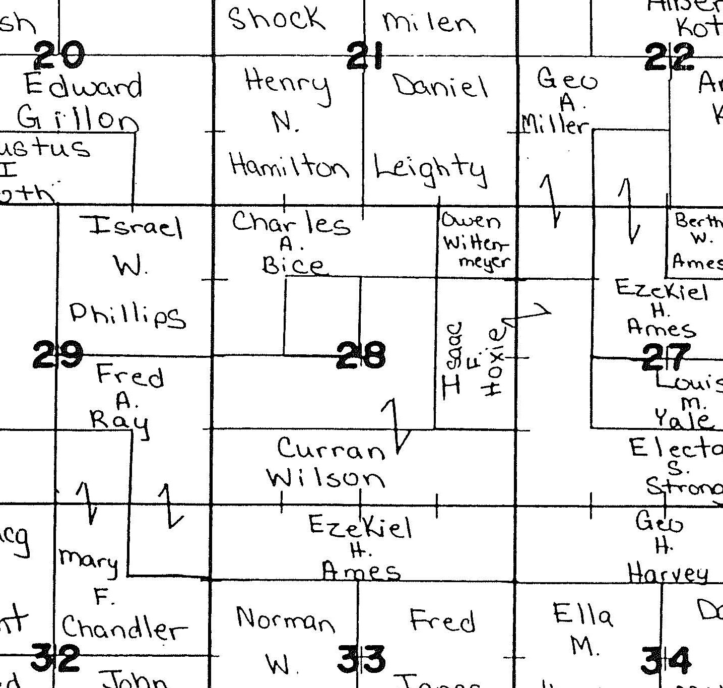
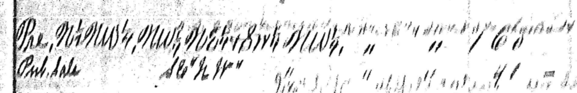
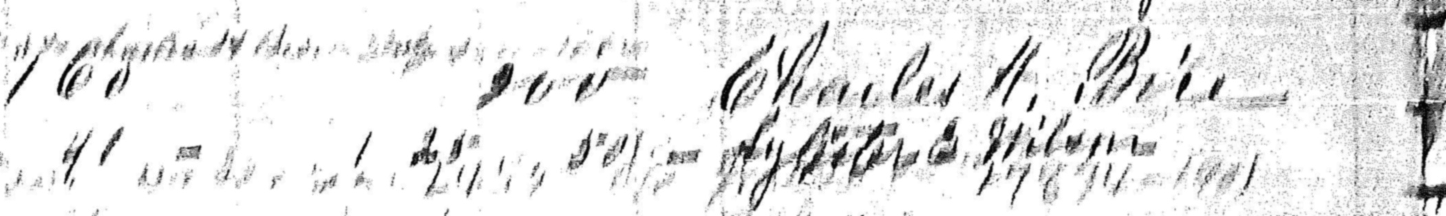
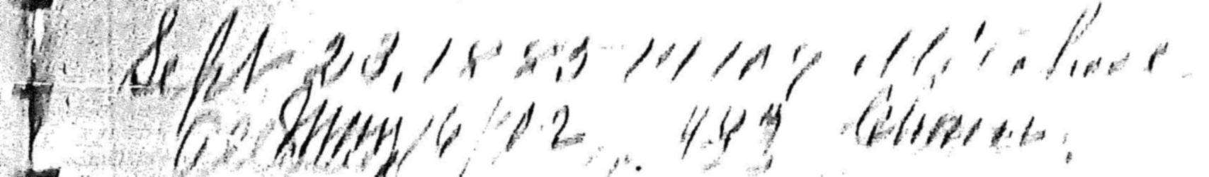
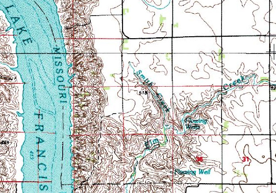
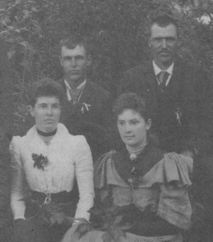
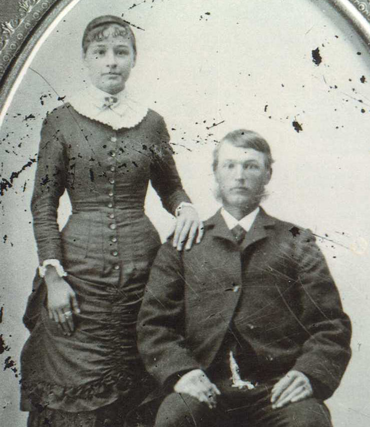
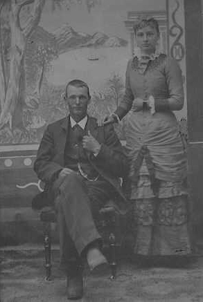
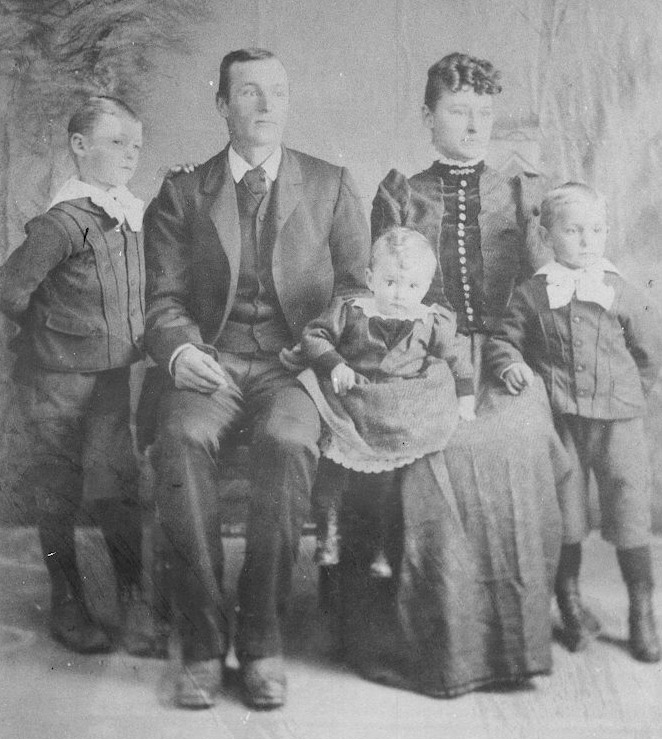
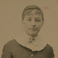
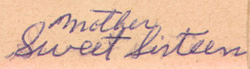
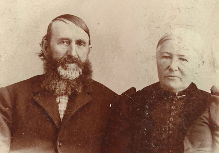
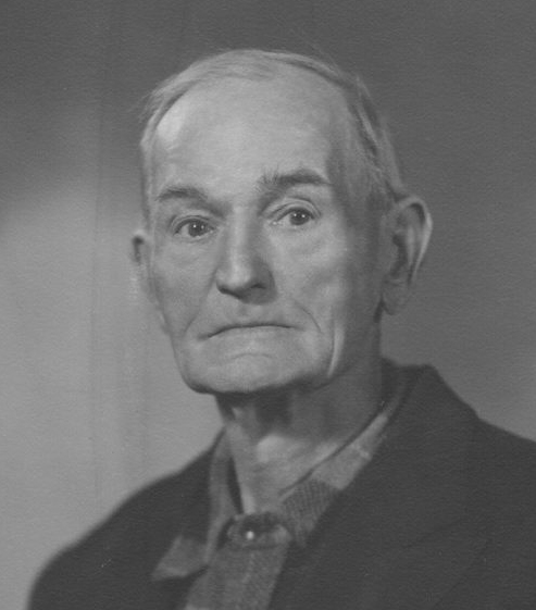
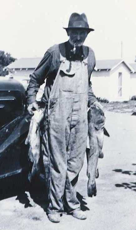
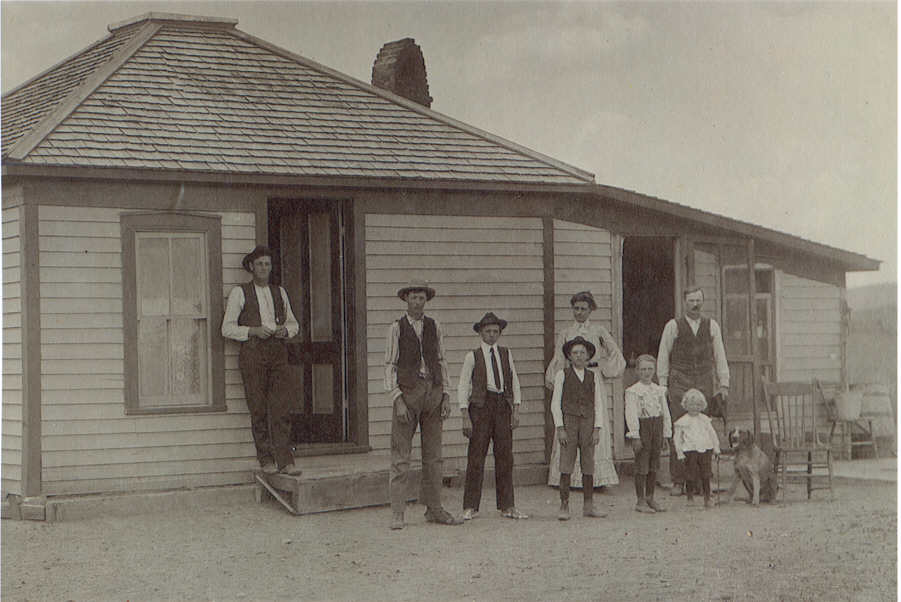
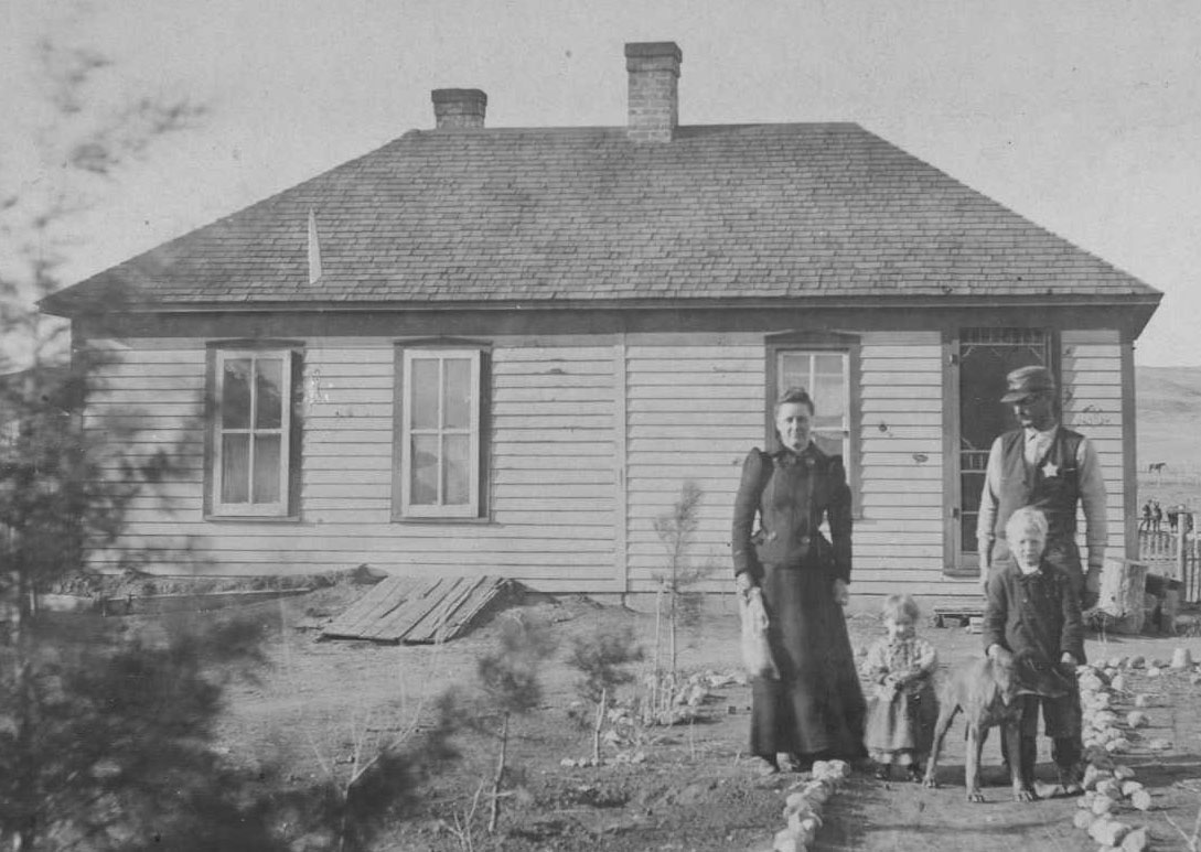
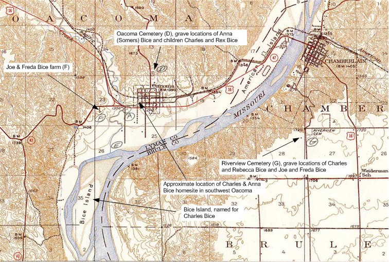
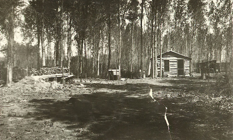
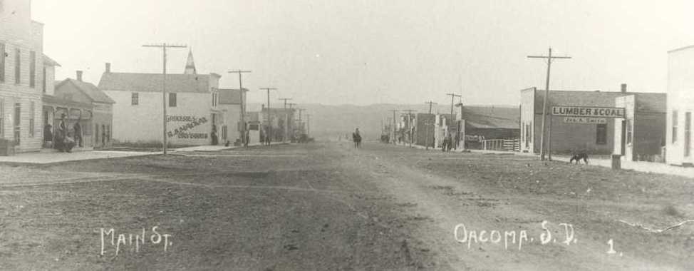
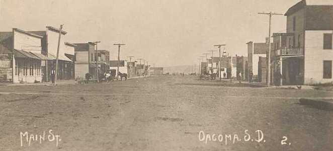
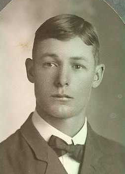
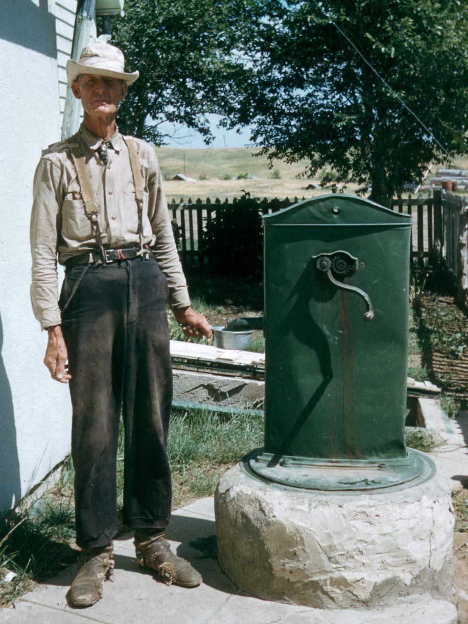
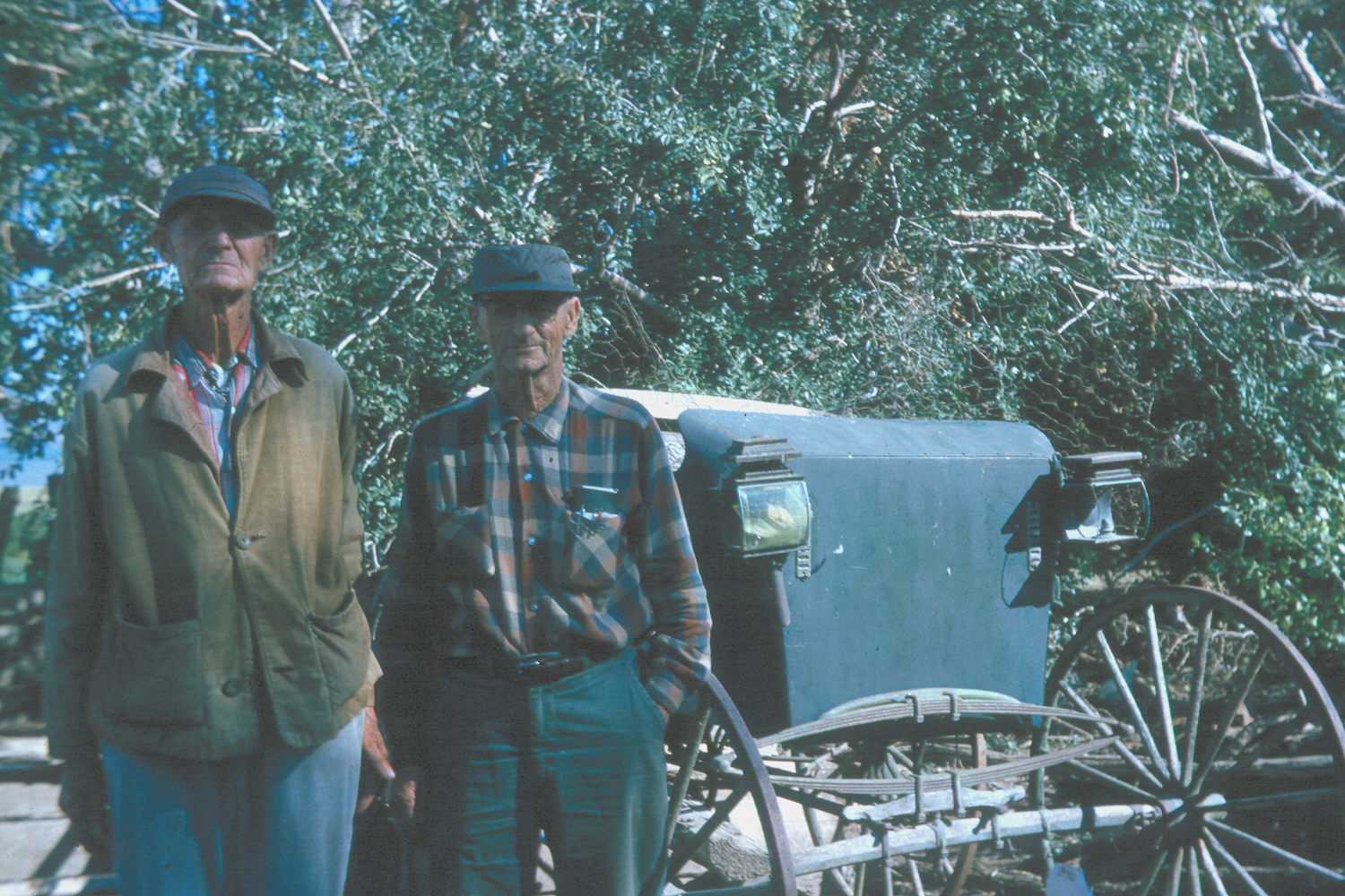
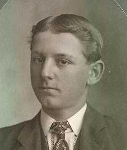
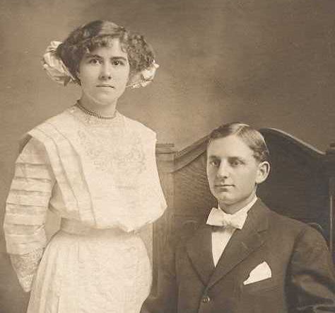
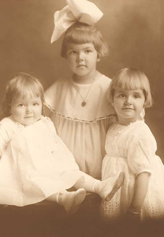
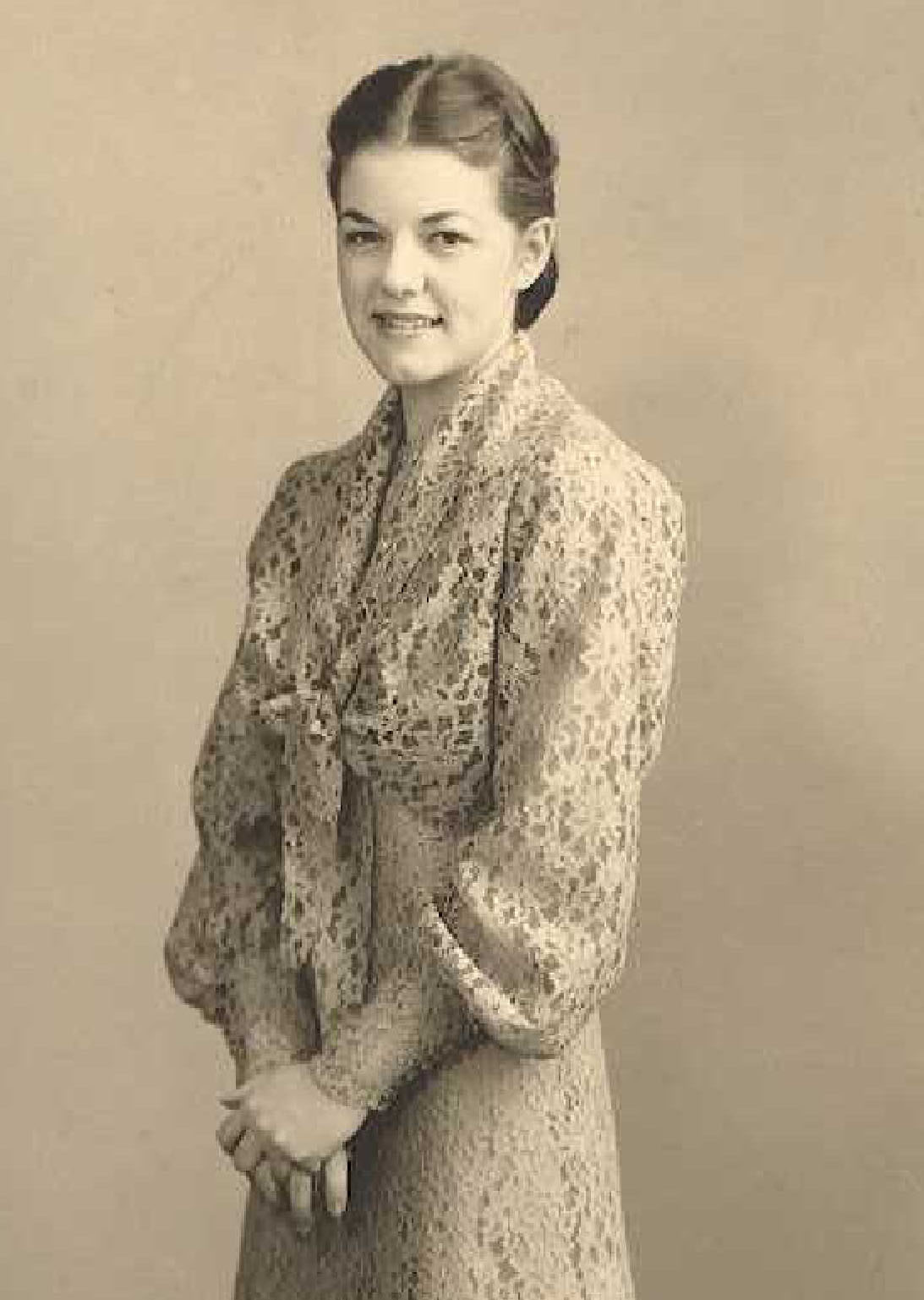
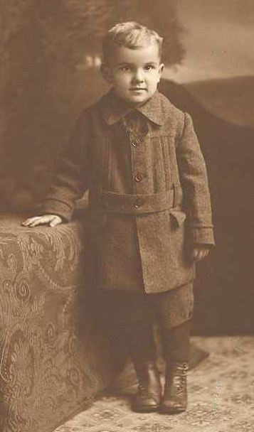
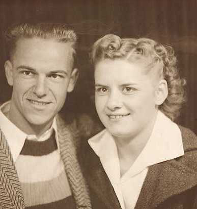

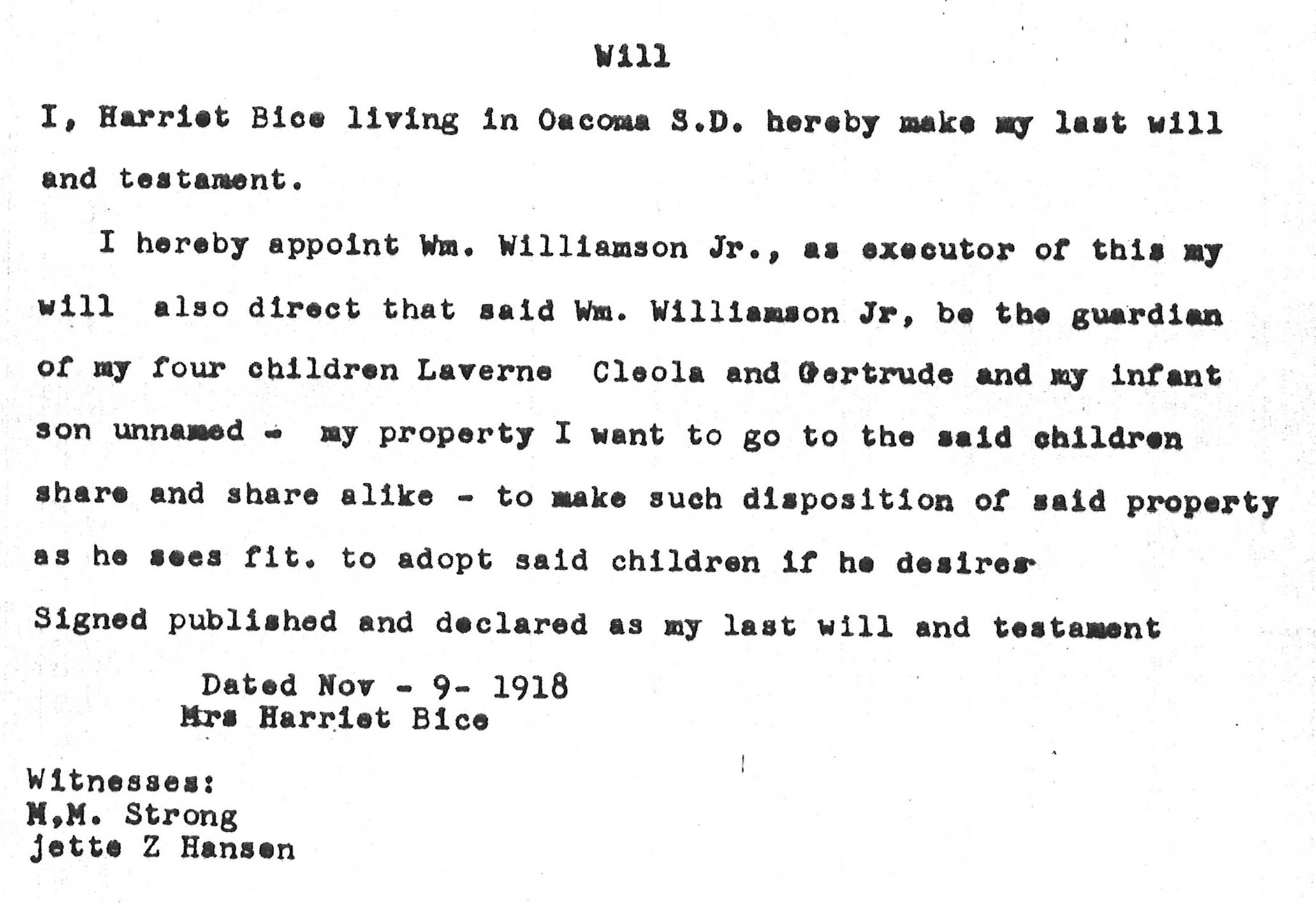
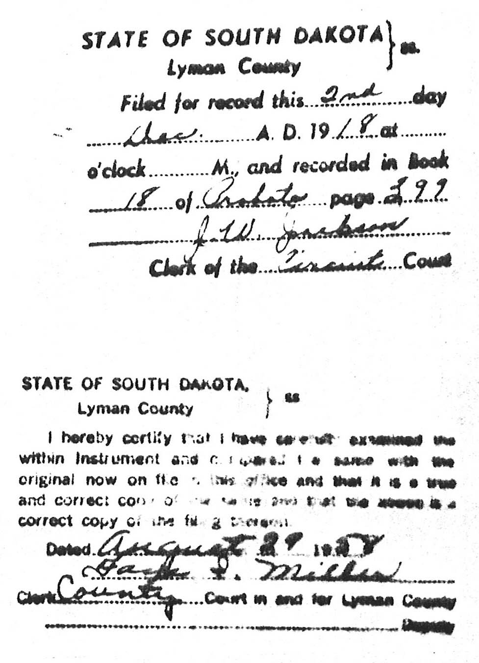
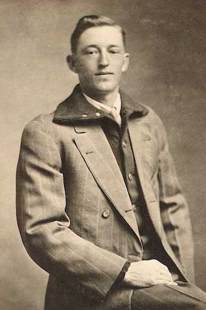

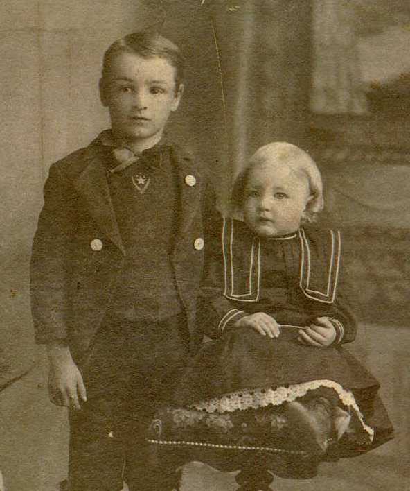
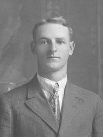
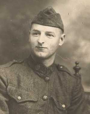
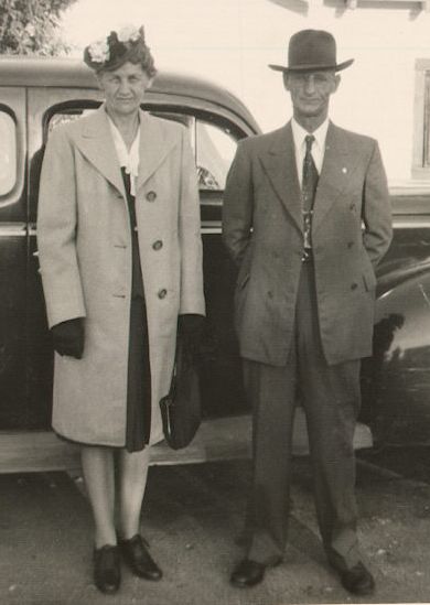
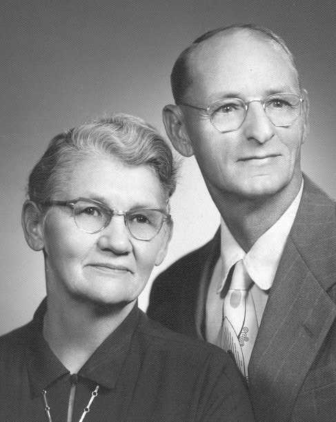
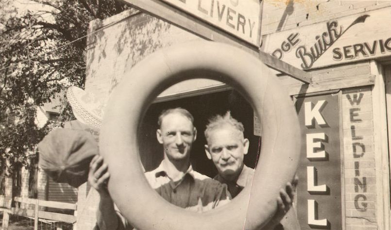
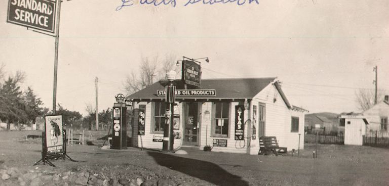
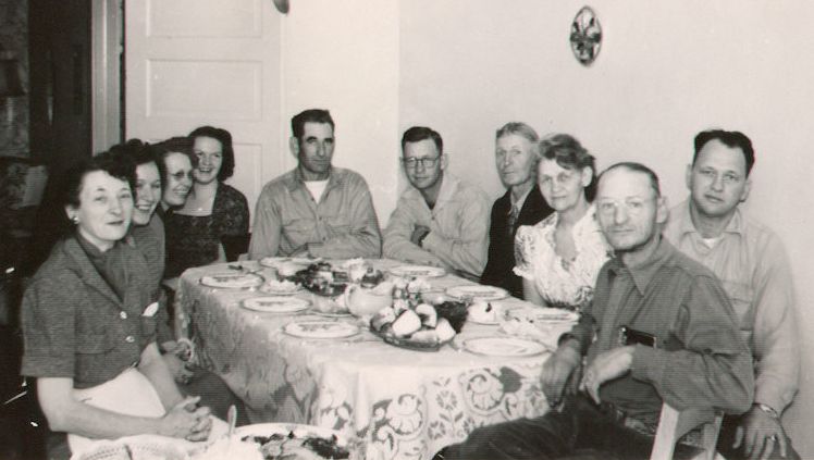
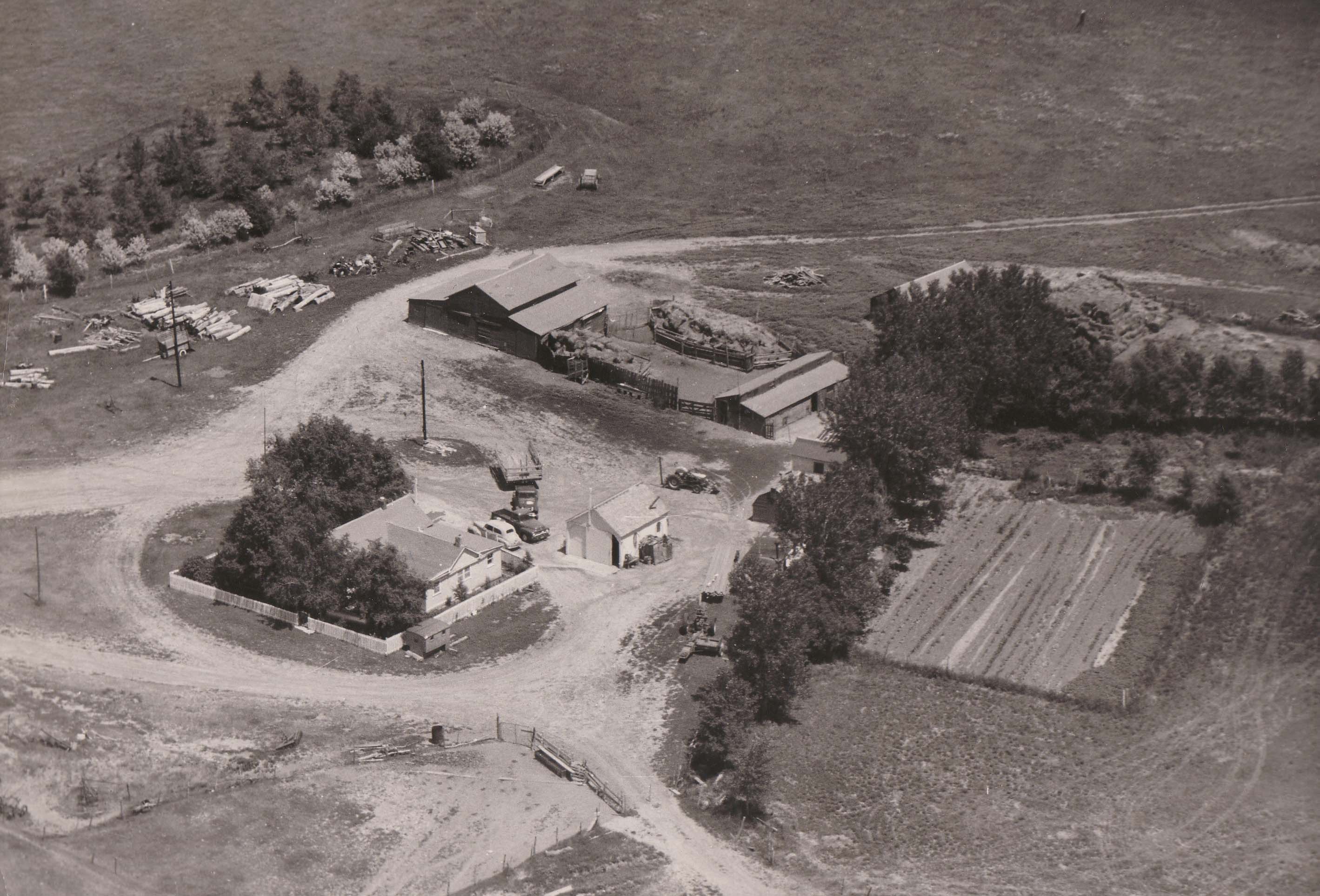
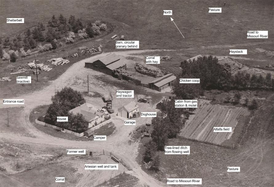
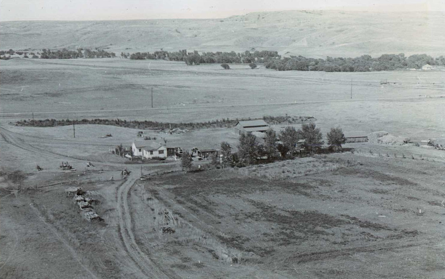
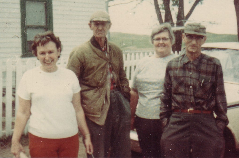
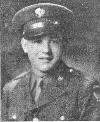
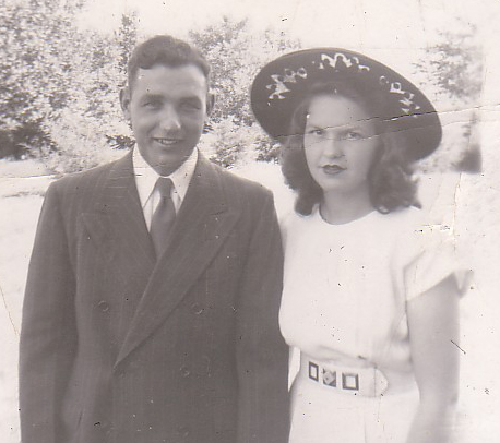
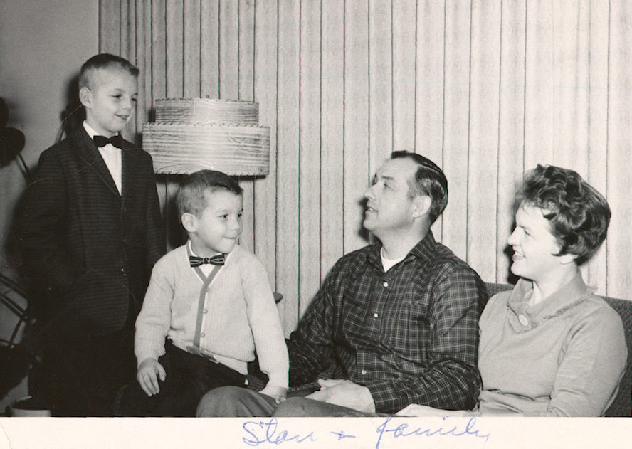
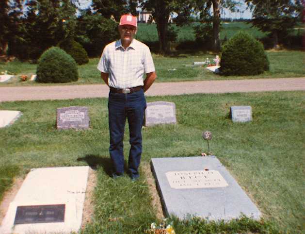
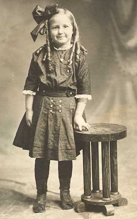
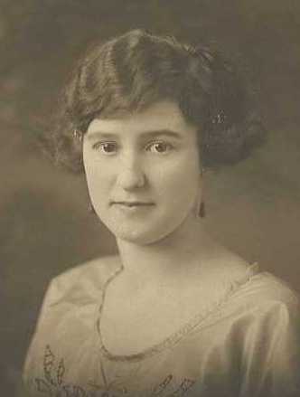
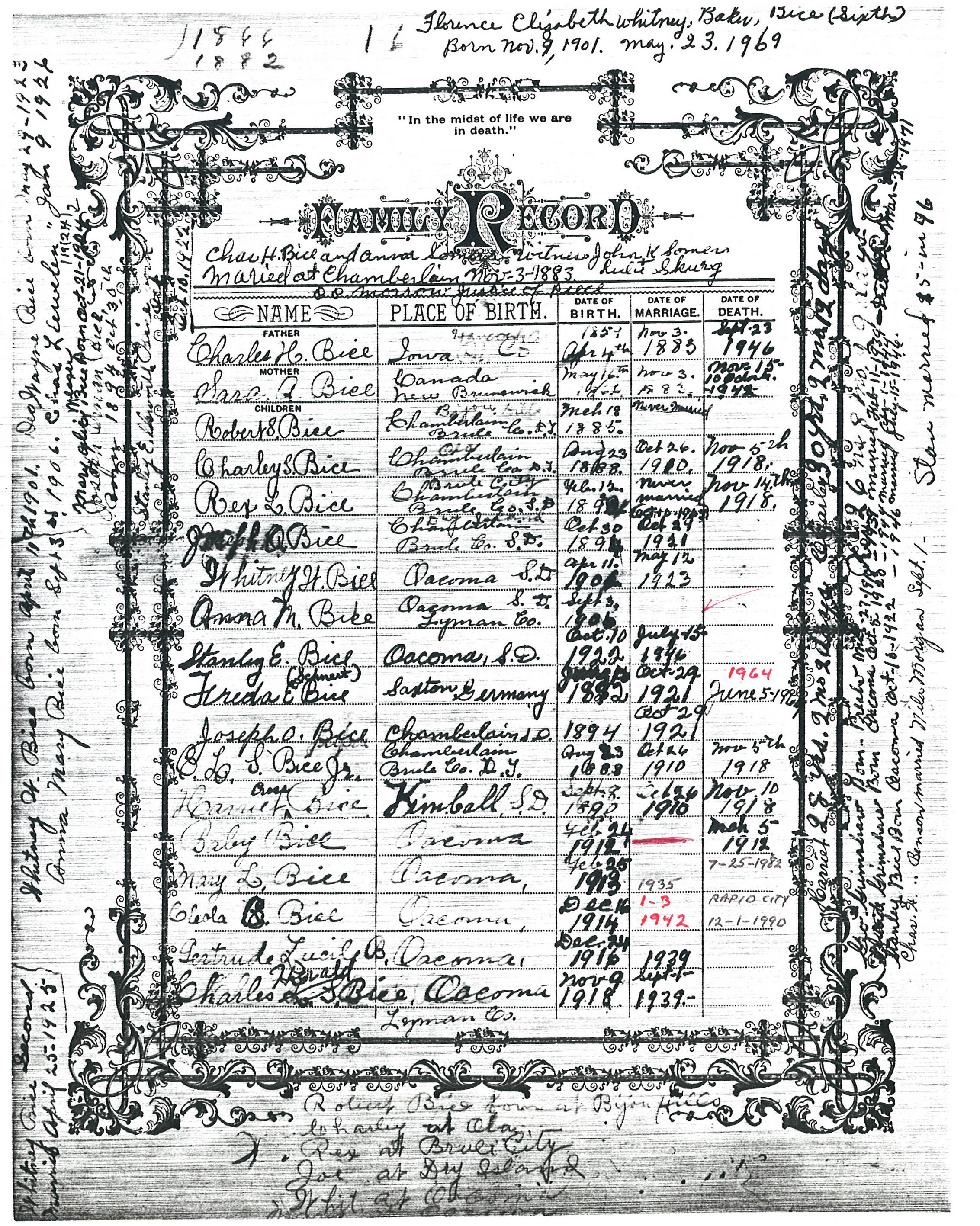
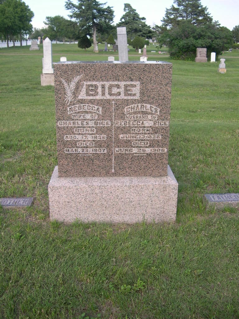
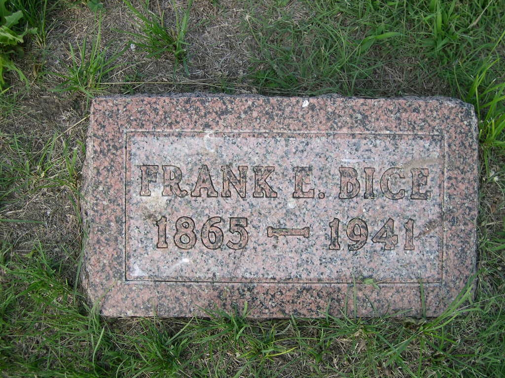
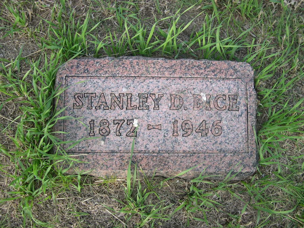
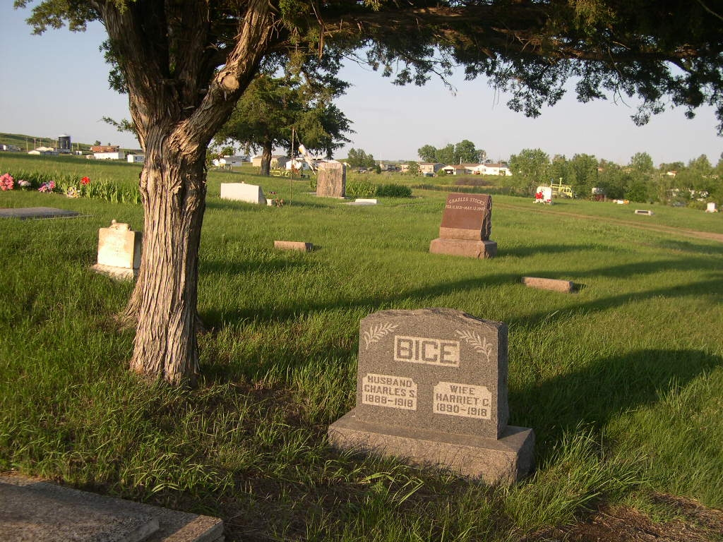
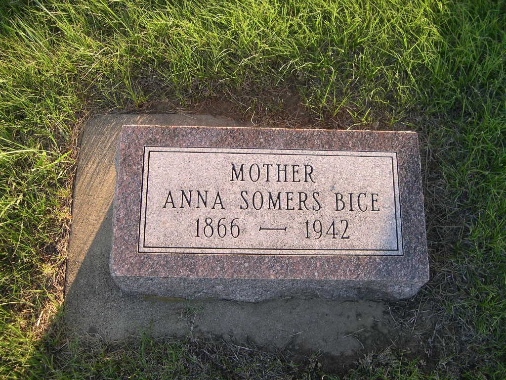
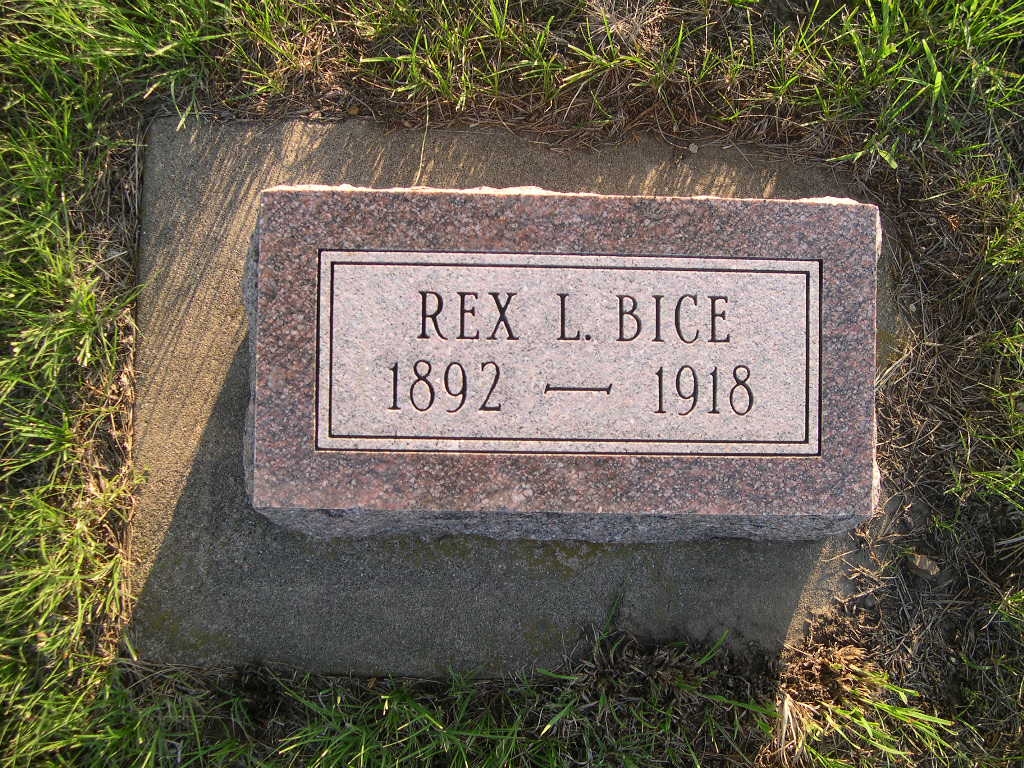
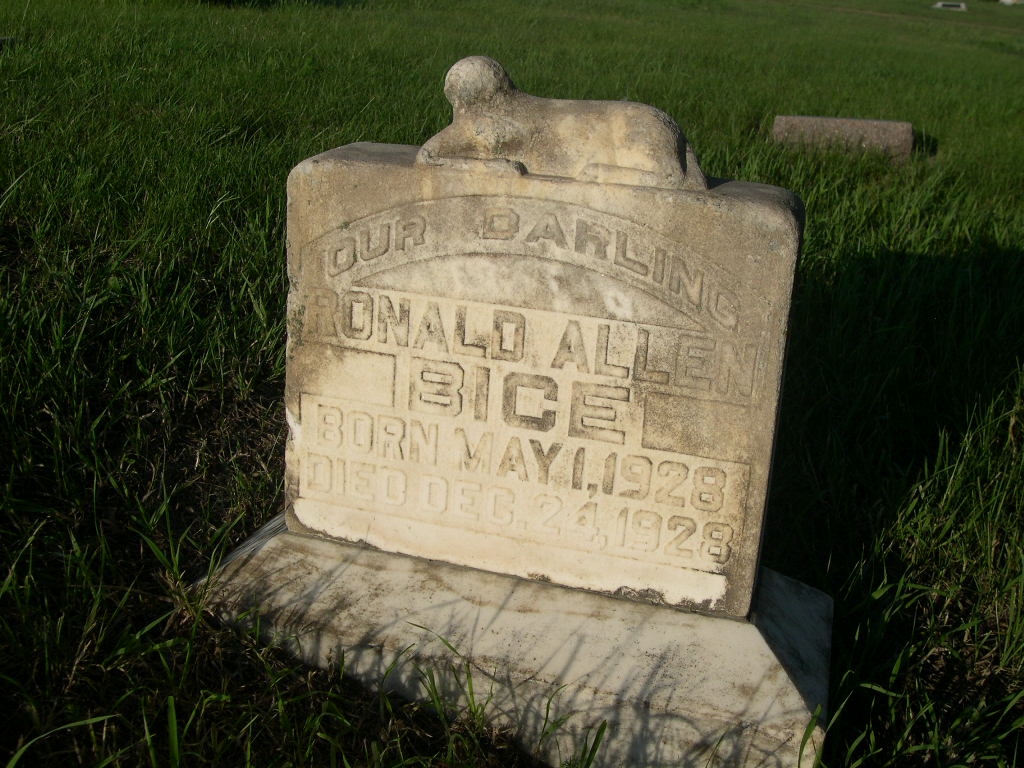
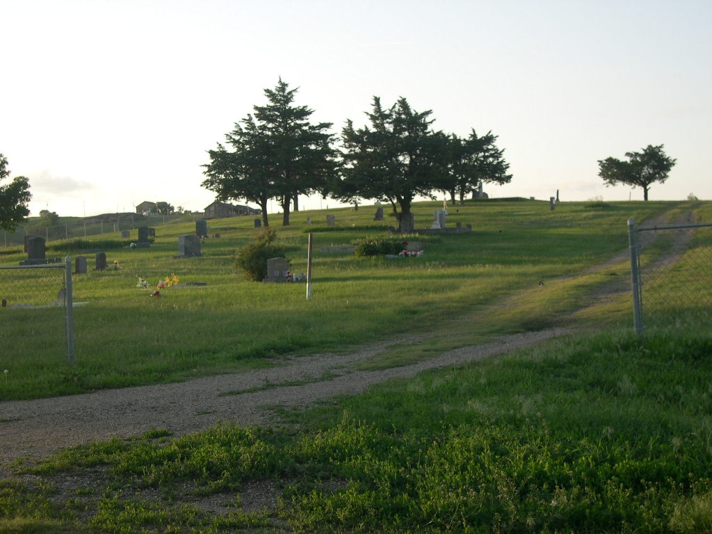
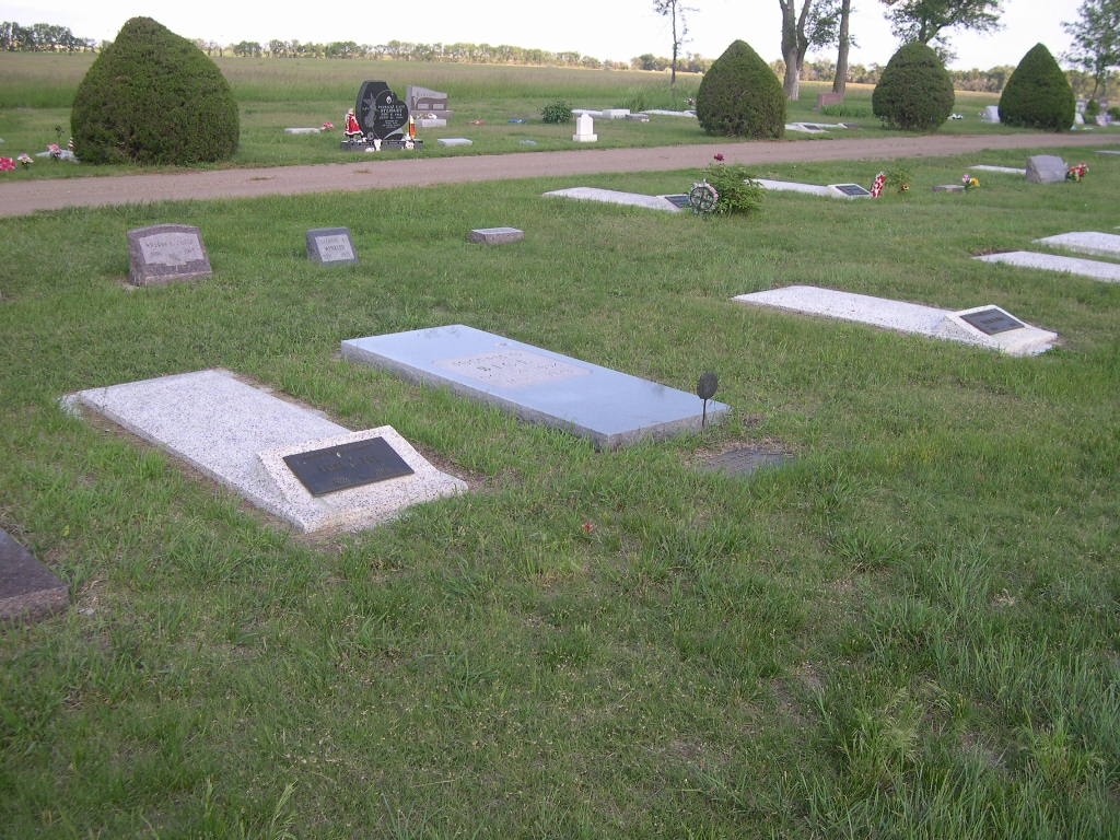
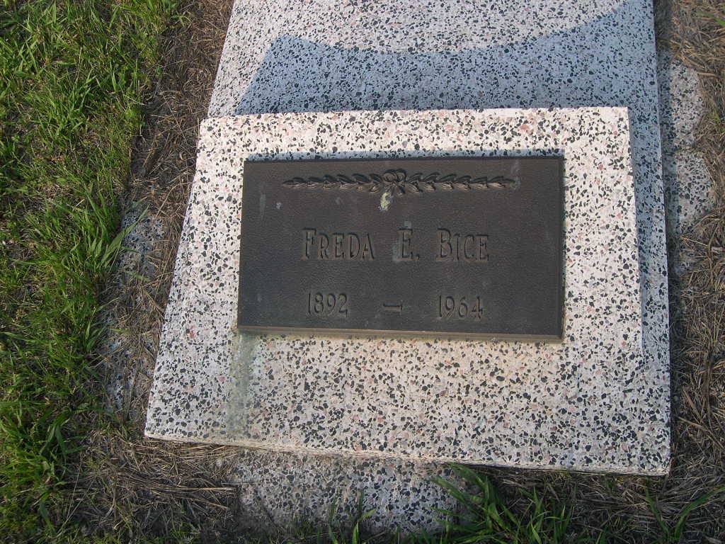
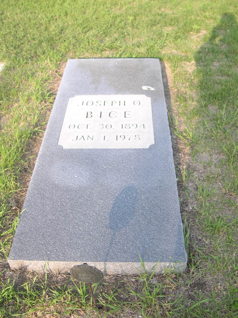
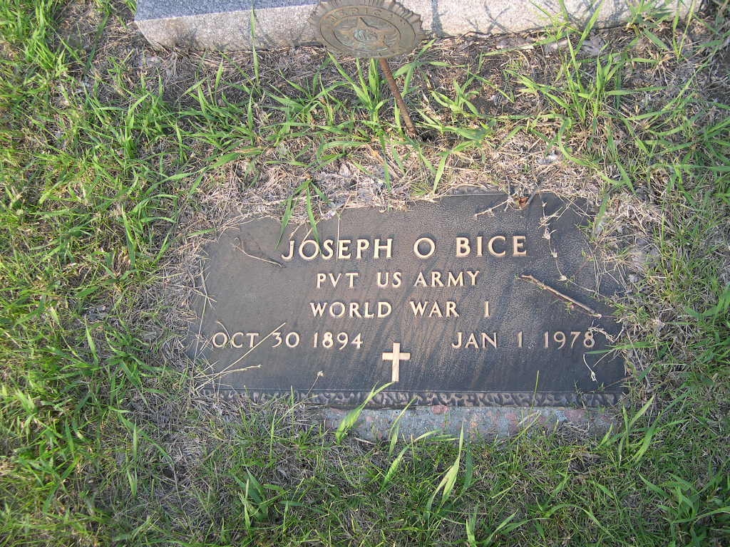
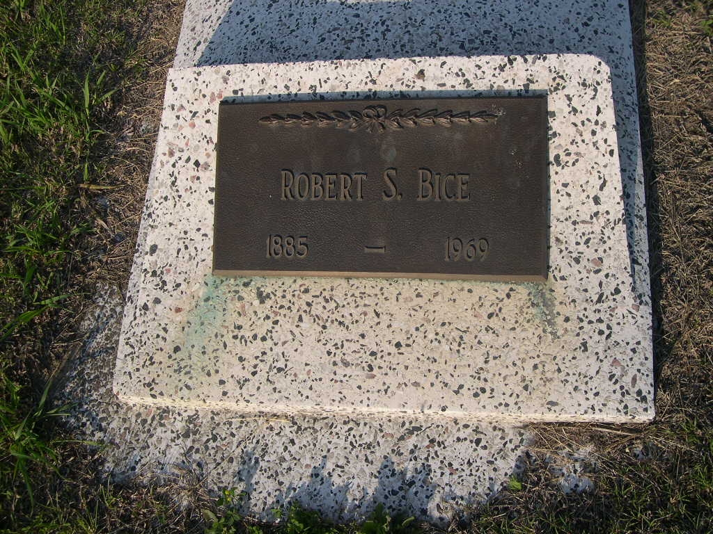

